- Matanuska-Susitna Borough, Alaska
-
Matanuska-Susitna Borough, Alaska 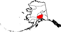
Location in the state of Alaska
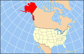
Alaska's location in the U.S.Founded 1964 Seat Palmer Area
- Total
- Land
- Water
25,260 sq mi (65,423 km²)
7,125 sq mi (18,454 km²), 2.29%Population
- (2010)
- Density
88,995
3/sq mi (1/km²)Website www.matsugov.us Matanuska-Susitna Borough (often referred to as the Mat-Su Borough) is a borough located in the state of Alaska, United States. As of 2010,[1] the population was 88,995. The borough seat is Palmer and the largest city in the borough is Wasilla. The Borough is part of the Anchorage Metropolitan Statistical Area.
The Mat-Su Borough is so designated because it contains the entire Matanuska and Susitna Rivers. These rivers empty into Cook Inlet which is the southern border of the Mat-Su Borough. This area is one of the few agricultural areas of Alaska.
Contents
Geography
The borough has a total area of 25,260 square miles (65,400 km2), of which, 24,682 square miles (63,930 km2) of it is land and 578 square miles (1,500 km2) of it (2.29%) is water.
Adjacent boroughs and census areas
- Denali Borough, Alaska - north
- Southeast Fairbanks Census Area, Alaska - northeast
- Valdez-Cordova Census Area, Alaska - east
- Municipality of Anchorage, Alaska - south
- Kenai Peninsula Borough, Alaska - south
- Bethel Census Area, Alaska - west
- Yukon-Koyukuk Census Area, Alaska - west

Denali Borough Southeast Fairbanks Census Area Bethel Census Area and Yukon-Koyukuk Census Area 
Valdez-Cordova Census Area  Matanuska-Susitna Borough, Alaska

Municipality of Anchorage and Kenai Peninsula Borough National protected areas
- Chugach National Forest (part)
- Denali National Park and Preserve (part)
- Denali Wilderness (part)
- Lake Clark National Park and Preserve (part)
- Lake Clark Wilderness (part)
Demographics
Historical populations Census Pop. %± 1970 6,509 — 1980 17,816 173.7% 1990 39,683 122.7% 2000 59,322 49.5% 2010 88,995 50.0% source:[2] As of 2008, (Alaska Dept. of Labor) there were 82,515 people residing in the borough. According to the 2000 Census, the population density was 2 people per square mile (1/km²). There were 27,329 housing units at an average density of 1 per square mile (0/km²). The racial makeup of the borough was 87.55% White, 0.69% Black or African American, 5.50% Native American, 0.70% Asian, 0.12% Pacific Islander, 0.86% from other races, and 4.57% from two or more races. 2.50% of the population were Hispanic or Latino of any race.
There were 20,556 households out of which 42.30% had children under the age of 18 living with them, 58.90% were married couples living together, 9.10% had a female householder with no husband present, and 26.80% were non-families. 20.30% of all households were made up of individuals and 4.10% had someone living alone who was 65 years of age or older. The average household size was 2.84 and the average family size was 3.29.
In the borough the population was spread out with 32.20% under the age of 18, 7.40% from 18 to 24, 31.10% from 25 to 44, 23.40% from 45 to 64, and 5.90% who were 65 years of age or older. The median age was 34 years. For every 100 females there were 108.20 males. For every 100 females age 18 and over, there were 108.10 males.
Schools in the Borough are administered by the Matanuska-Susitna Borough School District.
Politics and government
Matanuska-Susitna was among a few places in America carried by Ross Perot in the 1992 presidential election.[3] Attorney and history teacher, Talis Colberg was the Mayor of the Borough. Colberg left the seat in October 2010 to become the College Director of Matanuska-Susitna College. The Borough has a strong manager form of government. Acting Borough Manager Elizabeth Gray is presently running operations. Long-time Manager John Duffy retired in 2010.[4]
Cities and towns
- Alexander (Creek)
- Big Lake
- Buffalo Soapstone
- Butte
- Chase
- Chickaloon
- Dinglishna Hills
- Farm Loop
- Fishhook
- Gateway
- Glacier View
- Houston
- Knik River
- Knik-Fairview
- Lake Louise
- Lakes
- Lazy Mountain
- Meadow Lakes
- Palmer
- Petersville
- Point MacKenzie
- Skwentna
- Susitna
- Sutton-Alpine
- Talkeetna
- Tanaina
- Trapper Creek
- Wasilla
- Willow
- Y
See also
- Matanuska-Susitna Valley
- List of Airports in the Matanuska-Susitna Borough
- Matanuska Formation
References
- ^ Alaska Dept. of Labor
- ^ "Census Of Population and Housing". U.S. Census Bureau. http://www.census.gov/prod/www/abs/decennial/index.htm. Retrieved 2011-04-21.
- ^ Geographie Electorale
- ^ [1]
External links
- Matanuska-Susitna Borough official government website
- Matanuska-Susitna Borough, Alaska at the Open Directory Project
- Borough map: Alaska Department of Labor
Municipalities and communities of Matanuska-Susitna Borough, Alaska Cities 
CDPs Big Lake | Buffalo Soapstone | Butte | Chase | Chickaloon | Farm Loop | Fishhook | Gateway | Glacier View | Knik River | Knik-Fairview | Lake Louise | Lakes | Lazy Mountain | Meadow Lakes | Petersville | Point MacKenzie | Skwentna | Susitna | Sutton-Alpine | Talkeetna | Tanaina | Trapper Creek | Willow | Y
Unincorporated
communities State of Alaska
Topics - Index
- Geography
- Climate
- Wildlife
- History
- People
- Transportation
- Government
- Delegations
- Music
- Visitor attractions
Society - Culture
- Crime
- Demographics
- Economy
- Education
- Health (Rural dentistry)
- Politics
Regions - Aleutian Islands
- Arctic Alaska
- Bush Alaska
- Inside Passage
- Interior
- Kenai Peninsula
- Mat‑Su Valley
- North Slope
- Southeast
- Seward Peninsula
- Southcentral
- Southwest
- Tanana Valley
- Yukon–Kuskokwim Delta
Largest cities Boroughs Census Areas - Aleutians West
- Bethel
- Dillingham
- Hoonah‑Angoon
- Nome
- Petersburg
- Prince of Wales‑Hyder
- Southeast Fairbanks
- Valdez‑Cordova
- Wade Hampton
- Yukon‑Koyukuk
Categories:- Alaska boroughs
- Matanuska-Susitna Borough, Alaska
- Anchorage metropolitan area


Wikimedia Foundation. 2010.