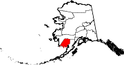
- Dillingham Census Area, Alaska
-
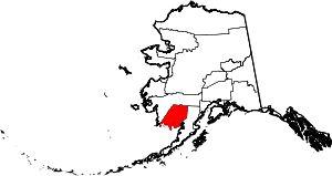
Dillingham Census Area is a census area located in the state of Alaska, United States. As of the 2000 census, the population was 4,922. It is part of the unorganized borough and therefore has no borough seat. Its largest community by far is the city of Dillingham, on a small arm of Bristol Bay on the Bering Sea.
Contents
Geography
The census area has a total area of 20,928 square miles (54,200 km2), of which, 18,675 square miles (48,370 km2) of it is land and 2,254 square miles (5,840 km2) of it (10.77%) is water.
Adjacent boroughs and census areas
- Bethel Census Area, Alaska - west/north
- Lake and Peninsula Borough, Alaska - east

Bethel Census Area Bethel Census Area 
Lake and Peninsula Borough  Dillingham Census Area, Alaska

Bering Sea National protected areas
- Alaska Maritime National Wildlife Refuge (part of the Bering Sea unit)
- Togiak National Wildlife Refuge (part)
- Togiak Wilderness (part)
Demographics
As of the census[1] of 2000, there were 4,922 people, 1,529 households, and 1,105 families residing in the census area. The population density was 0 people per square mile (0/km²). There were 2,332 housing units at an average density of 0/sq mi (0/km²). The racial makeup of the census area was 21.64% White, 0.37% Black or African American, 70.13% Native American, 0.61% Asian, 0.02% Pacific Islander, 0.55% from other races, and 6.68% from two or more races. 2.26% of the population were Hispanic or Latino of any race. 34.6% reported speaking Yupik or Eskimo at home [1].
There were 1,529 households out of which 45.30% had children under the age of 18 living with them, 51.10% were married couples living together, 15.00% had a female householder with no husband present, and 27.70% were non-families. 23.30% of all households were made up of individuals and 3.60% had someone living alone who was 65 years of age or older. The average household size was 3.20 and the average family size was 3.84.
In the census area the population was spread out with 38.10% under the age of 18, 7.70% from 18 to 24, 28.90% from 25 to 44, 19.50% from 45 to 64, and 5.70% who were 65 years of age or older. The median age was 29 years. For every 100 females there were 109.00 males. For every 100 females age 18 and over, there were 108.80 males. The per capita income is estimated at 23,500 U.S. dollars per year.
Cities and towns
- Aleknagik
- Clark's Point
- Dillingham
- Ekwok
- Koliganek
- Manokotak
- New Stuyahok
- Portage Creek
- Togiak
- Twin Hills
See also
- List of airports in the Dillingham Census Area
External links
Municipalities and communities of Dillingham Census Area, Alaska Cities Aleknagik | Clark's Point | Dillingham | Ekwok | Manokotak | New Stuyahok | Togiak
CDPs Unincorporated
communities State of Alaska
Topics - Index
- Geography
- Climate
- Wildlife
- History
- People
- Transportation
- Government
- Delegations
- Music
- Visitor attractions
Society - Culture
- Crime
- Demographics
- Economy
- Education
- Health (Rural dentistry)
- Politics
Regions - Aleutian Islands
- Arctic Alaska
- Bush Alaska
- Inside Passage
- Interior
- Kenai Peninsula
- Mat‑Su Valley
- North Slope
- Southeast
- Seward Peninsula
- Southcentral
- Southwest
- Tanana Valley
- Yukon–Kuskokwim Delta
Largest cities Boroughs Census Areas - Aleutians West
- Bethel
- Dillingham
- Hoonah‑Angoon
- Nome
- Petersburg
- Prince of Wales‑Hyder
- Southeast Fairbanks
- Valdez‑Cordova
- Wade Hampton
- Yukon‑Koyukuk
Coordinates: 59°57′N 158°26′W / 59.95°N 158.43°W
References
- ^ "American FactFinder". United States Census Bureau. http://factfinder.census.gov. Retrieved 2008-01-31.
Categories:- Dillingham Census Area, Alaska
- Alaska census areas
- Counties of the United States with Native American majority populations

Wikimedia Foundation. 2010.