- North Slope Borough, Alaska
-
North Slope Borough, Alaska 
Seal
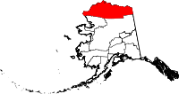
Location in the state of Alaska
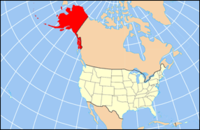
Alaska's location in the U.S.Founded 1972 Seat Barrow Area
- Total
- Land
- Water
94,763 sq mi (245,435 km²)
88,695.413 sq mi (229,720 km²)
5,946 sq mi (15,400 km²), 6.4%Population
- (2010)
- Density
9,430
0.106/sq mi (0/km²)Website www.north-slope.org North Slope Borough is a borough located largely in the North Slope region of the U.S. state of Alaska. As of the 2000 census, the population was 9,430. The borough seat is Barrow. As of 2010, the mayor is Edward Itta.[1]
Contents
Geography
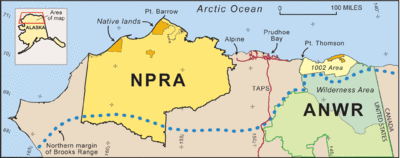
The borough has a total area of 94,763 square miles (245,440 km2), of which, 88,695.413 square miles (229,720.07 km2)[2] of it is land and 6,067.6 square miles (15,715 km2) –6.4%– is water. The borough is larger than 39 states.[3]
Its western coastline is along the Chukchi Sea, while its eastern shores (beyond Point Barrow) are on the Beaufort Sea.
The North Slope Borough is the largest county-level political subdivision in the United States by area, with a larger land area than that of the state of Utah. Although the adjacent Yukon-Koyukuk Census Area is larger in area, it has no borough-level government. The borough is also the third-least densely populated county-level entity in the United States (after the Yukon-Koyukuk Census Area and the Lake and Peninsula Borough).
Adjacent boroughs and census areas
- Yukon-Koyukuk Census Area, Alaska - southeast
- Northwest Arctic Borough, Alaska - southwest
It also shares its eastern border with Yukon, Canada, which has no subdivisions.

Arctic Ocean 

Yukon Territory, Canada  North Slope Borough, Alaska

Northwest Arctic Borough Yukon-Koyukuk Census Area National protected areas
- Alaska Maritime National Wildlife Refuge (part of the Chukchi Sea unit)
- Cape Lisburne
- Cape Thompson
- Arctic National Wildlife Refuge (part)
- Mollie Beattie Wilderness (part)
- Gates of the Arctic National Park and Preserve (part)
- Noatak National Preserve (part)
- Noatak Wilderness (part)
Other federal areas
Demographics
As of the census[4] of 2010, there were 7,385 people, 2,109 households, and 1,524 families residing in the borough. The population density was 12.03 square miles (31.2 km2) per person. There were 2,538 housing units at an average density of 35 square miles (91 km2) per unit. The racial makeup of the borough was 17.09% White, 0.72% Black or African American, 68.38% Native American, mostly Inuit, 5.92% Asian, 0.84% Pacific Islander, 0.50% from other races, and 6.55% from two or more races. 2.37% of the population was Hispanic or Latino of any race. 42.84% reported speaking Iñupiaq or "Eskimo" at home, while 4.21% speak Tagalog.[5]
There were 2,109 households out of which 48.10% had children under the age of 18 living with them, 43.3% were married couples living together, 18.3% had a female householder with no husband present, and 27.70% were non-families. 21.4% of all households were made up of individuals and 1.9% had someone living alone who was 65 years of age or older. The average household size was 3.45 and the average family size was 4.05.
In the borough the population was spread out with 38.2% under the age of 18, 9.50% from 18 to 24, 30.1% from 25 to 44, 18.10% from 45 to 64, and 4.2% who were 65 years of age or older. The median age was 27 years. For every 100 females there were 112.50 males. For every 100 females age 18 and over, there were 113.90 males.
See also
- Inuit
- Eskimo
- Nalukataq -- traditional blanket toss celebrations
- List of airports in the North Slope Borough
Cities and towns
External links
Municipalities and communities of North Slope Borough, Alaska Borough seat: Barrow Cities Anaktuvuk Pass | Atqasuk | Barrow | Kaktovik | Nuiqsut | Point Hope | Wainwright
CDPs Unincorporated
communities State of Alaska
Juneau (capital) Topics Index · Geography · Climate · Wildlife · History · People · Transportation · Government · Delegations · Music · Visitor attractions
Society Culture · Crime · Demographics · Economy · Education · Health (Rural dentistry) · Politics
Regions Aleutian Islands · Arctic Alaska · Bush Alaska · Inside Passage · Interior · Kenai Peninsula · Mat‑Su Valley · North Slope · Southeast · Seward Peninsula · Southcentral · Southwest · Tanana Valley · Yukon–Kuskokwim Delta
Largest cities Boroughs Aleutians East · Anchorage · Bristol Bay · Denali · Fairbanks North Star · Haines · Juneau · Kenai Peninsula · Ketchikan Gateway · Kodiak Island · Lake and Peninsula · Matanuska‑Susitna · North Slope · Northwest Arctic · Sitka · Skagway · Wrangell · Yakutat · Unorganized
Census Areas Aleutians West · Bethel · Dillingham · Hoonah‑Angoon · Nome · Petersburg · Prince of Wales‑Hyder · Southeast Fairbanks · Valdez‑Cordova · Wade Hampton · Yukon‑Koyukuk
Coordinates: 69°18′N 153°27′W / 69.30°N 153.45°W
References
- ^ Delbridge, Rena (April 9, 2010). "North Slope mayor fights for local voice". Alaska Dispatch. http://www.alaskadispatch.com/dispatches/politics/4831-north-slope-mayor-fights-for-local-voice. Retrieved 2011 October 14.
- ^ "American FactFinder". United States Census Bureau. http://factfinder2.census.gov. Retrieved 2011-05-14.
- ^ Reiss, Bob. "The Mayor at the Top of the World". July 18, 2010. http://www.parade.com/news/2010/07/18-the-mayor-at-the-top-of-the-world.html.[not in citation given]
- ^ "American FactFinder". United States Census Bureau. http://factfinder.census.gov. Retrieved 2008-01-31.
- ^ "MLA Language Map Data for North Slope County, Alaska". http://www.mla.org/map_data. Retrieved 2011 October 14.
Categories:- Alaska boroughs
- North Slope Borough, Alaska
- Counties of the United States with Native American majority populations
- Chukchi Sea
- Beaufort Sea
Wikimedia Foundation. 2010.


