- California State Route 237
-
State Route 237
Southbay Freeway 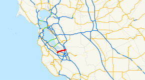
Route information Defined by S&HC § 537 Maintained by Caltrans Length: 11 mi[1] (17.70 km) Major junctions West end:  SR 82 in Mountain View
 SR 85 in Mountain View
 US 101 in Sunnyvale
 I-880 in Milpitas
East end:  I-680 in Milpitas
Highway system State highways in California(list • pre-1964)
History • Unconstructed • Deleted • Freeway • Scenic←  SR 236
I-238  →
→State Route 237 runs from El Camino Real (SR 82) in Mountain View to Interstate 680 in Milpitas. It runs south of the San Francisco Bay, connecting the East Bay to the Peninsula.
This route is part of the California Freeway and Expressway System.[2]
Contents
Route description
It intersects with Highway 101 at the southern corner of Moffett Field. It also has a major intersection with Interstate 880. Westbound traffic can connect to Highway 85 southbound, but the eastbound traffic connection to 85 northbound is labeled as an exit for U.S. 101.
Half a mile from the highway's western terminus, to the I-880 intersection, Route 237 is constructed to Interstate standards, and is named the Southbay Freeway. It is not part of the Interstate system, however, despite a sign on the ramp to it from Northbound I-680 to the contrary. East of I-880 in Milpitas, it becomes a surface street, Calaveras Boulevard, and the highway designation terminates at the intersection with I-680. West of El Camino Real in Mountain View, it becomes a surface street, Grant Road.
It begins at a junction with El Camino Real (CA-82) in Mountain View as a freeway with two lanes in each direction, although most traffic comes from State Route 85. After an intersection with US Route 101, Mathilda Avenue, and Fair Oaks Avenue, a carpool lane is added for a total of 3 lanes in either direction. It remains like this as it passes the companies where commuters work, to its east end of the freeway at I-880, where most eastbound traffic is directed to northbound 880. The route becomes a street, Calaveras Boulevard, in Milpitas, terminating at I-680. Calaveras Blvd becomes Calaveras Road.
Route 237 is known for the many Silicon Valley companies that line its route.
Before Route 237 was upgraded to freeway status in the mid-1990s, it was a 4-6 lane street, known as Alviso-Milpitas Road or Milpitas-Alviso Road depending on different maps showing the description.
The Route 237 corridor has long been sought as a location for a freeway connector between Interstates 680 and 880. Many possible sites have been suggested, from Montague Expressway in North San Jose to Mission Boulevard in Fremont. One map printed before 237's construction to freeway standards between Alviso and 880 showed a new freeway across bay wetlands between Alviso and the Scott Creek Road interchange in South Fremont. Grading and underpasses for a freeway interchange are presently visible along 680 near Scott Creek Road. [1]
Route 237 is known for a number of companies that define Silicon Valley's technological landscape. Many major software and hardware manufacturers have their headquarters along 237. Some of these manufacturers include Lockheed-Martin, Brocade Communications Systems, Nortel Networks, Cisco Systems, Yahoo!, TiVo, Ariba and NetApp.
Route 237 also passes Moffett Federal Airfield, a large former military air base in the Bay Area, and Onizuka Air Force Station, locally known as the blue cube.
Highway 237 Bikeway
The Highway 237 Bikeway is a 5-mile (8.0 km) pedestrian and bicycle path that parallels State Route 237. The majority of the path is separated from vehicular traffic, however, two sections comprising a total of 1.5 miles (2.4 km) follow an on-street alignment adjacent the freeway.
This bikeway serves as an important connector in the network of trails in San Jose and Santa Clara County. It intersects with the Guadalupe River Trail, which provides access to Downtown San Jose, as well as the San Tomas Aquino Creek and Coyote Creek trails.[3]
Major intersections
- Note: Except where prefixed with a letter, postmiles were measured in 1964, based on the alignment as it existed at that time, and do not necessarily reflect current mileage.
The entire route is in Santa Clara County.
Location Postmile
[4][5][6]Exit
[7]Destinations Notes Mountain View R0.00 Grant Road Continuation beyond SR 82 R0.00 1A SR 82 (El Camino Real) – Mountain View, Los AltosWest end of freeway R0.38 1A US 101 north (via SR 85 north) – San FranciscoEastbound exit and westbound entrance R0.38 1B SR 85 south to SR 82 south – Los Gatos, Santa CruzWestbound exit and eastbound entrance R0.61 1B Dana Street, Evelyn Avenue, Whisman Road Signed as exit 1C westbound M1.55 2 Middlefield Road, Maude Avenue Sunnyvale 2.48 3A US 101 south (Bayshore Freeway) – San JoseWestbound exit is via exit 3B 2.48 3A US 101 north (Bayshore Freeway) – San FranciscoEastbound exit is via exit 3B 2.99 3B Mathilda Avenue – Sunnyvale Former SR 9 south R3.97 4 Fair Oaks Avenue Eastbound exit and westbound entrance R4.60 5 Lawrence Expressway (CR G2), Caribbean Drive Santa Clara R5.83 6 Great America Parkway, Lafayette Street San Jose 6.87 7 North First Street 8.02 8 Zanker Road Milpitas R9.13 9A McCarthy Boulevard 9.34 9 I-880 (Nimitz Freeway) – Oakland, San JoseSigned as exits 9B (south) and 9C (north) East end of freeway Serra Way to Main Street Abel Street to Main Street 10.00 10 Main Street Interchange; westbound exit and eastbound entrance; former SR 238 Milpitas Boulevard 11.08 11 I-680 – Sacramento, San JoseInterchange; signed as exits 11A (south) and 11B (north) 11.08 Calaveras Boulevard Continuation beyond I-680 1.000 mi = 1.609 km; 1.000 km = 0.621 mi
Concurrency terminus • Closed/Former • Incomplete access • UnopenedSee also
- List of California State Routes
References
- ^ January 1, 2006 California Log of Bridges on State Highways
- ^ CA Codes (shc:250-257)
- ^ "Highway 237 Bikeway". San Jose Trail Network Website. City of San Jose. http://www.sjparks.org/Trails/Hwy237/Hwy237.asp. Retrieved 2008-03-31.
- ^ California Department of Transportation, State Truck Route List (XLS file), accessed February 2008
- ^ California Department of Transportation, Log of Bridges on State Highways, July 2007
- ^ California Department of Transportation, All Traffic Volumes on CSHS, 2005 and 2006
- ^ California Department of Transportation, California Numbered Exit Uniform System, SR-237 Eastbound and SR-237 Westbound, accessed February 2008
External links
- Caltrans: Route 237 highway conditions
- California Highways: SR 237
- Highway 237 / I-880 Interchange Reconstruction Project
San Francisco Bay Area Freeways Italics denote former routes.Interstates and U.S. Routes I-80 (James Lick / Eastshore / San Francisco Skyway) · US 101 (South Valley / Bayshore / Redwood Highway / Central) · I-238 · I-280 (Junipero Serra / Southern / Sinclair) · I-380 (Kopp) · CA 480 (Embarcadero) · I-580 (MacArthur) · I-680 (Sinclair) · I-780 · I-880 (Nimitz Freeway) · I-980 (Grove-Shafter)
California State Routes CA 1 (Cabrillo Highway) · CA 4 (John Muir Parkway) · CA 12 (Burbank Freeway) · CA 13 (Warren Freeway) · CA 17 (Santa Cruz Highway) · CA 24 (Grove-Shafter Freeway) · CA 29 (Vallejo-Napa Freeway) · CA 37 (Sears Point Freeway/Marine World Parkway) · CA 84 (Dumbarton Bridge) · CA 85 (West Valley Freeway) · CA 87 (Guadalupe Freeway) · CA 92 (San Mateo-Hayward Bridge/Younger Freeway) · CA 160 (Antioch Bridge) · CA 237 (South Bay Freeway) · CA 242 (Concord Freeway)Named interchanges Bridges Golden Gate Bridge · San Francisco – Oakland Bay Bridge · San Mateo – Hayward Bridge · Dumbarton Bridge · Richmond – San Rafael Bridge · Carquinez Bridge · Benicia–Martinez Bridge · Antioch BridgeSee also Categories:- State highways in California
- San Francisco Bay Area freeways
- Roads in Santa Clara County, California
- Juan Bautista de Anza National Historic Trail


Wikimedia Foundation. 2010.