- Day Valley, California
-
Day Valley — census-designated place — Location in Santa Cruz County and the state of California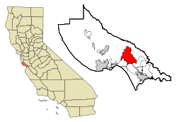
Coordinates: 37°0′32″N 121°51′24″W / 37.00889°N 121.85667°WCoordinates: 37°0′32″N 121°51′24″W / 37.00889°N 121.85667°W Country  United States
State  California
County Santa Cruz Area[1] – Total 18.807 sq mi (48.711 km2) – Land 18.807 sq mi (48.711 km2) – Water 0 sq mi (0 km2) 0% Elevation 1,316 ft (401 m) Population (2010) – Total 3,409 – Density 181.3/sq mi (70/km2) Time zone PST (UTC-8) – Summer (DST) PDT (UTC-7) ZIP code 95003 Area code(s) 831 FIPS code 06-18153 GNIS feature ID 1867010 Day Valley is a census-designated place (CDP) in Santa Cruz County, California, United States. The population was 3,409 at the 2010 census.
Contents
Geography
Day Valley is located at 37°0′32″N 121°51′24″W / 37.00889°N 121.85667°W (37.008820, -121.856544)[2].
According to the United States Census Bureau, the CDP has a total area of 18.8 square miles (49 km2), most of which is forest and meadows, with a creek at the crossroads of Valencia Rd. and Day Valley Rd.
Demographics
2010
The 2010 United States Census[3] reported that Day Valley had a population of 3,409. The population density was 181.3 people per square mile (70.0/km²). The racial makeup of Day Valley was 2,898 (85.0%) White, 20 (0.6%) African American, 23 (0.7%) Native American, 85 (2.5%) Asian, 4 (0.1%) Pacific Islander, 208 (6.1%) from other races, and 171 (5.0%) from two or more races. Hispanic or Latino of any race were 470 persons (13.8%).
The Census reported that 3,387 people (99.4% of the population) lived in households, 17 (0.5%) lived in non-institutionalized group quarters, and 5 (0.1%) were institutionalized.
There were 1,280 households, out of which 401 (31.3%) had children under the age of 18 living in them, 806 (63.0%) were opposite-sex married couples living together, 93 (7.3%) had a female householder with no husband present, 47 (3.7%) had a male householder with no wife present. There were 73 (5.7%) unmarried opposite-sex partnerships, and 14 (1.1%) same-sex married couples or partnerships. 236 households (18.4%) were made up of individuals and 93 (7.3%) had someone living alone who was 65 years of age or older. The average household size was 2.65. There were 946 families (73.9% of all households); the average family size was 2.99.
The population was spread out with 682 people (20.0%) under the age of 18, 261 people (7.7%) aged 18 to 24, 623 people (18.3%) aged 25 to 44, 1,285 people (37.7%) aged 45 to 64, and 558 people (16.4%) who were 65 years of age or older. The median age was 48.0 years. For every 100 females there were 101.0 males. For every 100 females age 18 and over, there were 99.3 males.
There were 1,366 housing units at an average density of 72.6 per square mile (28.0/km²), of which 1,007 (78.7%) were owner-occupied, and 273 (21.3%) were occupied by renters. The homeowner vacancy rate was 1.3%; the rental vacancy rate was 1.8%. 2,676 people (78.5% of the population) lived in owner-occupied housing units and 711 people (20.9%) lived in rental housing units.
2000
As of the census[4] of 2000, there were 3,587 people, 1,283 households, and 946 families residing in the CDP. The population density was 188.7 people per square mile (72.9/km²). There were 1,346 housing units at an average density of 70.8 per square mile (27.3/km²). The racial makeup of the CDP was 86.37% White, 0.64% African American, 1.14% Native American, 1.67% Asian, 6.83% from other races, and 3.35% from two or more races. Hispanic or Latino of any race were 14.47% of the population.
There were 1,283 households out of which 35.6% had children under the age of 18 living with them, 63.4% were married couples living together, 6.4% had a female householder with no husband present, and 26.2% were non-families. 18.6% of all households were made up of individuals and 5.8% had someone living alone who was 65 years of age or older. The average household size was 2.78 and the average family size was 3.15.
In the CDP the population was spread out with 25.5% under the age of 18, 6.3% from 18 to 24, 23.7% from 25 to 44, 33.5% from 45 to 64, and 11.0% who were 65 years of age or older. The median age was 42 years. For every 100 females there were 97.1 males. For every 100 females age 18 and over, there were 96.8 males.
The median income for a household in the CDP was $72,438, and the median income for a family was $78,310. Males had a median income of $61,615 versus $43,854 for females. The per capita income for the CDP was $31,694. About 2.0% of families and 5.4% of the population were below the poverty line, including 4.7% of those under age 18 and 3.9% of those age 65 or over.
Politics
In the state legislature Day Valley is located in the 15th Senate District, represented by Republican Abel Maldonado, and in the 27th Assembly District, represented by Democrat Bill Monning. Federally, Day Valley is located in California's 17th congressional district, which has a Cook PVI of D +17[5] and is represented by Democrat Sam Farr.
Local History
Many early settlers to Day Valley (including some members of the Day and Cox families) are buried in a small cemetery in the Forest and Meadows neighborhood, at the corner of Meadow Road and Downing Drive. Cox Road and Day Valley Road are named after these families.
References
- ^ U.S. Census
- ^ "US Gazetteer files: 2010, 2000, and 1990". United States Census Bureau. 2011-02-12. http://www.census.gov/geo/www/gazetteer/gazette.html. Retrieved 2011-04-23.
- ^ All data are derived from the United States Census Bureau reports from the 2010 United States Census, and are accessible on-line here. The data on unmarried partnerships and same-sex married couples are from the Census report DEC_10_SF1_PCT15. All other housing and population data are from Census report DEC_10_DP_DPDP1. Both reports are viewable online or downloadable in a zip file containing a comma-delimited data file. The area data, from which densities are calculated, are available on-line here. Percentage totals may not add to 100% due to rounding. The Census Bureau defines families as a household containing one or more people related to the householder by birth, opposite-sex marriage, or adoption. People living in group quarters are tabulated by the Census Bureau as neither owners nor renters. For further details, see the text files accompanying the data files containing the Census reports mentioned above.
- ^ "American FactFinder". United States Census Bureau. http://factfinder.census.gov. Retrieved 2008-01-31.
- ^ "Will Gerrymandered Districts Stem the Wave of Voter Unrest?". Campaign Legal Center Blog. http://www.clcblog.org/blog_item-85.html. Retrieved 2008-02-10.
External links
Municipalities and communities of Santa Cruz County, California Cities 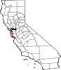
CDPs Amesti | Aptos | Aptos Hills-Larkin Valley | Ben Lomond | Bonny Doon | Boulder Creek | Brookdale | Corralitos | Davenport | Day Valley | Felton | Freedom | Interlaken | La Selva Beach | Live Oak | Lompico | Mount Hermon | Pajaro Dunes | Paradise Park | Pasatiempo | Pleasure Point | Rio del Mar | Seacliff | Soquel | Twin Lakes | Zayante
Unincorporated
communitiesOpal Cliffs | Summit | Swanton
Ghost
townCalifornia Central Coast Counties 
Cities and towns
100k-250kCities and towns
25k-100kAtascadero • Goleta • Hollister • Lompoc • Marina • Monterey • Orcutt • Paso Robles • San Luis Obispo • Santa Barbara • Santa Cruz • Santa Maria • Seaside • Soledad • WatsonvilleCities and towns
10k-25kArroyo Grande • Baywood-Los Osos • Capitola • Carpinteria • Greenfield • Grover Beach • Isla Vista • King City • Live Oak • Montecito • Morro Bay • Nipomo • Pacific Grove • Prunedale • Scotts ValleySub-regions Counties in italics sometimes included in the definition of the Central CoastCategories:- Census-designated places in Santa Cruz County, California


Wikimedia Foundation. 2010.