- Cima, California
-
Cima — Unincorporated Community — Cima, California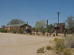 Location within the state of California
 Cima
CimaCoordinates: 35°14′16″N 115°29′57″W / 35.23778°N 115.49917°WCoordinates: 35°14′16″N 115°29′57″W / 35.23778°N 115.49917°W Country United States State California County San Bernardino
Mojave National Preserve
((southeast)-Mojave Desert)Elevation 4,175 ft (1,273 m) Population (2000) - Total 21 Time zone Pacific (PST) (UTC-8) - Summer (DST) PDT (UTC-7) ZIP codes 92323 Area code(s) 760 FIPS code GNIS feature ID 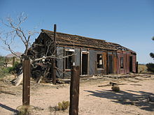 Abandoned building in Cima
Cima is a small unincorporated community in the Mojave Desert of San Bernardino County, California, in the United States. Few people live in the area. Cima is located in the south, upland of the Ivanpah Valley, south of the Ivanpah Mountains and Interstate 15, and lies at an elevation of 4,175 feet (1,273 m); it also lies in the center north of the Mojave National Preserve, with its neighbor town of Kelso, in the preserve just southwest. Cima was founded circa 1906, and served as a railroad siding and a commercial center for ranchers and miners. It is now usually considered a ghost town[1].
Average high temperature in July is 93 °F (34 °C) with an average low of 67°. January averages are 51 °F (11 °C) and 29F°. The highest temperature on record is 110 °F (43 °C) in 1967, with a low temperature of −2 °F (−19 °C) recorded in 1972. Cima receives less than 10 inches (250 mm) of rain in an average year. Cima lies to the southeast of the Cima Dome & Volcanic Field National Natural Landmark, which contains Cima Dome, at 5,745 feet (1,751 m) above sea level a prominent landmark along I-15. Between Kelso and Cima lies the Cima Grade, the steepest part of the rail line between the Los Angeles area and Las Vegas—the tracks rise 2,000 feet (610 m) in 20 miles (32 km).
Cima has a post office, with the ZIP code is 92323 and the area code 760. The 92323 ZIP Code Tabulation Area had a population of 21 at the 2000 census.[2]
References
- ^ Cima ghost town
- ^ "American FactFinder". United States Census Bureau. http://factfinder.census.gov. Retrieved 2008-01-31.
- Allan, Stuart (2005). California Road and Recreation Atlas. Benchmark Maps. p. 97. ISBN 0-929591-80-1.
- National Park Service - [1]
Categories:- Mojave National Preserve
- Ivanpah Valley
- Populated places in San Bernardino County, California
- Unincorporated communities in California
- Populated places in the Mojave Desert
- Ghost towns in California


Wikimedia Foundation. 2010.