- Eastvale, California
-
Eastvale — City — Eastvale Gateway - The main retail center for Eastvale, located at Interstate 15 off the Limonite exit. The San Gabriel Mountains can be seen in the background. In the foreground, construction of a stadium movie theater in the front.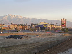 Location in Riverside County and the state of California
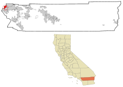
Coordinates: 33°57′47″N 117°33′50″W / 33.96306°N 117.56389°WCoordinates: 33°57′47″N 117°33′50″W / 33.96306°N 117.56389°W Country  United States
State  California
County Riverside Incorporated October 1, 2010 Government – Mayor Adam Rush – City Council Ric Welch
Kelly Howell
Ike C. Bootsma
Jeff DeGrandpreArea[1] – Total 11.445 sq mi (29.644 km2) – Land 11.405 sq mi (29.539 km2) – Water 0.040 sq mi (0.104 km2) 0.35% Elevation 627 ft (191 m) Population (2010) – Total 53,668 – Density 4,689.2/sq mi (1,810.5/km2) Time zone PST (UTC-8) – Summer (DST) PDT (UTC-7) ZIP code 92880 and 91752 Area code(s) 951 909 Website http://www.eastvalecity.org/ Eastvale is a city located in northwestern Riverside County, California, the Inland Empire region of Southern California. Its boundaries extend from Hellman Avenue to the West (the San Bernardino County Line), Bellgrave Avenue to the North (also the San Bernardino County Line), the Santa Ana River and Norco to the South, and Interstate 15 to the East.[2] The population was 53,668 at the 2010 census.
Contents
Geography
The Eastvale area is often incorrectly referred to as the Corona Valley.[3] Prior to incorporation, street addresses were addressed as "Corona, California" since the post office in that city was the closest one that could handle the volume from the new construction in the area.
The Los Angeles County line is approximately 8 miles northwest of Eastvale, while the Orange County line is approximately 5 miles to the southwest. The proximity of these last two heavily commercialized counties, and the fact that Eastvale is roughly squared between Interstate 15 and California State Routes 91, 60, and 71, has made Eastvale popular for those that commute to these counties for employment, making Eastvale something of a commuter town.
According to the Eastvale area plan,[4] Eastvale has a total area of 13.1 square miles (33.9 km²), of which 12.5 square miles (32.3 km²) is land and 0.6 square miles (1.6 km²), or 4.76%, is water.
According to the United States Census Bureau, the former census-designated place of Eastvale covered an area of 11.4 square miles (29.6 km²), 99.65% of it land, and 0.35% of it water.
Eastvale has two postal ZIP codes—92880 and 91752, with current mailing addresses of Corona and Mira Loma, respectively.[5]
Most of Eastvale, like most of western Riverside County, has the telephone area code of 951. However, according to the California Public Utilities Commission, because the 951 area code was split along telephone service areas and not strictly along county boundaries, some Eastvale residents still retain the older 909 area code.[6]
History
Eastvale, once a rural area, was predominantly dairy farms and agricultural until the late 1990s.[7] At that time, the area started to suburbanize to accommodate the influx of people coming from neighboring Orange and Los Angeles Counties seeking affordable housing.[8] Eastvale was particularly hit hard by the United States housing bubble that burst in the late 2000s. A large portion of the communities' homes were sold during the early and mid 2000's at highly inflated prices fueled by the subprime mortgage industry. In June, 2006, the median home in Eastvale was valued at $601,000 and had drastically fallen to $304,000 by June, 2009 according to Zillow representing a 50% decrease in home values over a span of three years.
Incorporation effort
Eastvale was one of several unincorporated areas of Riverside County that had strong community support for city incorporation. The passage of AB 1602 in the mid 2000's, a state bill that adds funds from vehicle license fees, made it easier for unincorporated areas to attain cityhood.[9] In 2008, the communities of Menifee, Sun City and Quail Valley merged and incorporated as the City of Menifee. The law also stirred up renewed interest in incorporation efforts for Mira Loma and Jurupa Valley (Mira Loma, Pedley, Glen Avon, Sunnyslope, and Rubidoux).
The community of Eastvale actively attempted to incorporate from the mid 2000’s through 2010. The incorporation effort was being led by the Eastvale Incorporation Committee.[10] Other groups are also proponents of Eastvale cityhood, such as the Yes on Eastvale Cityhood Committee.
The incorporation effort was opposed by the Not NOW Eastvale group that was co-chaired by one of the 18 City Council candidates as well as other groups. These groups feared that the city had not developed a strong enough tax base to sustain itself as a city and all the responsibilities that come along with incorporation largely due to the dependence on state Vehicle Licens Fees (VLFs) for more than one third of the then proposed city's revenue. Others contested that the services provided by Riverside County, such as police and fire, were sufficient and another layer of government not needed. Many were not opposed to incorporation but rather to the timing of the incorporation effort.
The Eastvale Incorporation Committee successfully gathered enough signatures to qualify for the June 8, 2010. "Measure A" was placed on the ballot deciding incorporation. “Measure B” would decide how the city council would be elected: at large, by district, or from district. Measure A passed with 65.8% of voters approving incorporation.[11] Eastvale officially incorporated on October 1, 2010.[12] Voters also decided that the city council would be elected at large.
Demographics
Historical populations Census Pop. %± 1940 755 — 1950 780 3.3% 1960 785 0.6% 1970 1,587 102.2% 1980 1,599 0.8% 1990 1,587 −0.8% 2000 6,011 278.8% 2010 53,668 792.8% The 2010 United States Census[13] reported that Eastvale had a population of 53,668. The population density was 4,689.0 people per square mile (1,810.4/km²). The racial makeup of Eastvale was 22,998 (42.9%) White, 5,190 (9.7%) African American, 290 (0.5%) Native American, 13,003 (24.2%) Asian, 198 (0.4%) Pacific Islander, 9,172 (17.1%) from other races, and 2,817 (5.2%) from two or more races. Hispanic or Latino of any race were 21,445 persons (40.0%).
The Census reported that 53,660 people (100% of the population) lived in households, 2 (0%) lived in non-institutionalized group quarters, and 6 (0%) were institutionalized.
There were 13,640 households, out of which 8,556 (62.7%) had children under the age of 18 living in them, 9,983 (73.2%) were opposite-sex married couples living together, 1,385 (10.2%) had a female householder with no husband present, 893 (6.5%) had a male householder with no wife present. There were 701 (5.1%) unmarried opposite-sex partnerships, and 109 (0.8%) same-sex married couples or partnerships. 871 households (6.4%) were made up of individuals and 93 (0.7%) had someone living alone who was 65 years of age or older. The average household size was 3.93. There were 12,261 families (89.9% of all households); the average family size was 4.05.
The population was spread out with 17,786 people (33.1%) under the age of 18, 4,516 people (8.4%) aged 18 to 24, 18,659 people (34.8%) aged 25 to 44, 10,203 people (19.0%) aged 45 to 64, and 2,504 people (4.7%) who were 65 years of age or older. The median age was 30.9 years. For every 100 females there were 98.1 males. For every 100 females age 18 and over, there were 96.5 males.
There were 14,494 housing units at an average density of 1,266.4 per square mile (488.9/km²), of which 11,276 (82.7%) were owner-occupied, and 2,364 (17.3%) were occupied by renters. The homeowner vacancy rate was 3.1%; the rental vacancy rate was 3.1%. 43,936 people (81.9% of the population) lived in owner-occupied housing units and 9,724 people (18.1%) lived in rental housing units.
Law and government
Eastvale's first city council was elected on June 8, 2010, a few months before it was officially incorporated: Adam Rush, Ric Welch, Kelly Howell, Ike C. Bootsma, and Jeff DeGrandpre.[14]
Eastvale, situated in California's 44th congressional district, is represented in the United States House of Representatives by Ken Calvert. Barbara Boxer and Dianne Feinstein represent California in the United States Senate.
Prior to incorporation, Eastvale, along with most of the northwestern tip of Riverside County, was under the jurisdiction of the Second District of Riverside County.[15]
The Riverside County Integrated Project (RCIP),[16] an inclusive three-part county urban plan, has a specific plan attributed to the Eastvale area.[4] This area plan sets up Eastvale zoning ordinance, policy areas for unique features found in Eastvale, specific plans (master-planned communities) in Eastvale, design guidelines, circulation (transportation) policies for Eastvale, specific hazards to the region, and conservation policies—which includes the protection of open space, wetlands, and biodiversity.
Community
A committee of concerned Eastvale residents, the Eastvale Community Committee (ECC), was formed in so that issues facing the growing community would be addressed. Formed in 2002, the ECC holds public meetings with county representatives, utility operators, law enforcement agencies, local school representatives, and local business owners. A group of volunteer residents publishes a summary of the meetings and other articles in the quarterly Eastvale Edition which is mailed to most residents and is also available online.[17]
A separate project, Eastvale Events,[18] encourages community involvement by developing and coordinating community events. Eastvale Picnic in the Park, Eastvale Holiday Showcase, and Eastvale Fall Festival[19][20] are a few of the sponsored events.
Eastvale Little League, a subsidiary of the non-profit organization Little League Baseball, offers baseball and softball programs to boys and girls in Eastvale.[21]The Eastvale Law Enforcement And FireFighters (ELEAFF)[22] is the first resident Police and Fire Association in the United States. The association was developed by an Azuza Police officer, Los Angeles County Deputy Sheriff, Chino Valley Firefighter and a retired California Department of Corrections Officer.
Education
Eastvale is a part of the Corona-Norco Unified School District.[23][24]
- Elementary schools (within Eastvale boundaries)
- Clara Barton Elementary
- Harada Elementary
- Rosa Parks Elementary
- Eastvale Elementary
- VanderMolen Elementary
- Intermediate schools (within Eastvale boundaries)
- River Heights Intermediate School
- Augustine Ramirez Intermediate School EST.2011
- High schools (within Eastvale boundaries)
- Eleanor Roosevelt High School
References
- ^ U.S. Census
- ^ Riverside LAFCO Eastvale Incorporation Documents
- ^ Bender, Mary. “Map error gives city acres of confusion”, The Press-Enterprise, November 23, 2005, retrieved February 3, 2007
- ^ a b Riverside County Integrated Project – Eastvale Area Plan
- ^ Bender, Mary. “Eastvale sports first trappings of cityhood”, The Press-Enterprise, March 24, 2007, retrieved March 29, 2007.
- ^ California Public Utilities Commission - 951 Area Code Split
- ^ Bender, Mary. “Out to Pasture”, The Press-Enterprise, September 11, 2006, retrieved November 10, 2006.
- ^ Polakovic, Gary. “Inland areas called key to state's future”, Los Angeles Times, March 28, 2007, retrieved March 29, 2007.
- ^ Nealon, Sean and Bender, Mary. “New law boosts cityhood efforts”, The Press-Enterprise, September 28, 2006, retrieved November 10, 2006.
- ^ Eastvale Incorporation Committee
- ^ Riverside County Registrar of Voters June 8, 2010 Election Results
- ^ Stokley, Sandra (October 1, 2010). "EASTVALE: Residents celebrate their new city". The Press-Enterprise. http://www.pe.com/localnews/stories/PE_News_Local_D_weastvale02.30f570d.html. Retrieved October 2, 2010.
- ^ All data are derived from the United States Census Bureau reports from the 2010 United States Census, and are accessible on-line here. The data on unmarried partnerships and same-sex married couples are from the Census report DEC_10_SF1_PCT15. All other housing and population data are from Census report DEC_10_DP_DPDP1. Both reports are viewable online or downloadable in a zip file containing a comma-delimited data file. The area data, from which densities are calculated, are available on-line here. Percentage totals may not add to 100% due to rounding. The Census Bureau defines families as a household containing one or more people related to the householder by birth, opposite-sex marriage, or adoption. People living in group quarters are tabulated by the Census Bureau as neither owners nor renters. For further details, see the text files accompanying the data files containing the Census reports mentioned above.
- ^ http://www.voteinfo.net/eresults/56/Election%20Result_dtl.htm#cont482
- ^ Supervisor Tavaglione, Second District – County of Riverside Board of Supervisors
- ^ Riverside County Integrated Project
- ^ Eastvale Edition
- ^ Eastvale Events
- ^ Bender, Mary. “Festival offers farm life amid tract homes”, The Press-Enterprise, October 11, 2006, retrieved November 10, 2006.
- ^ Soifer, Jerry. “Eastvale ushers in autumn with fest”, The Press-Enterprise, October 14, 2006, retrieved November 10, 2006.
- ^ Mira Loma Little League
- ^ http://www.eleaff.org/
- ^ Corona-Norco Unified School District
- ^ Press-Enterprise, August 8, 2006, retrieved November 10, 2006.
External links
- City of Eastvale - Official web site
- - Eastvale Chamber of Commerce
- The Press-Enterprise – Eastvale Local News

Pomona Ontario Fontana Chino 
Jurupa Valley  Eastvale

Yorba Linda Corona Riverside Municipalities and communities of Riverside County, California Cities Banning | Beaumont | Blythe | Calimesa | Canyon Lake | Cathedral City | Coachella | Corona | Desert Hot Springs | Eastvale | Hemet | Indian Wells | Indio | Jurupa Valley | La Quinta | Lake Elsinore | Menifee | Moreno Valley | Murrieta | Norco | Palm Desert | Palm Springs | Perris | Rancho Mirage | Riverside | San Jacinto | Temecula | Wildomar
CDPs Aguanga | Anza | Bermuda Dunes | Cabazon | Cherry Valley | Coronita | Crestmore Heights | Desert Center | Desert Edge | Desert Palms | East Hemet | El Cerrito | El Sobrante | French Valley | Garnet | Glen Avon | Good Hope | Green Acres | Highgrove | Home Gardens | Homeland | Idyllwild-Pine Cove | Indio Hills | Lake Mathews | Lake Riverside | Lakeland Village | Lakeview | March ARB | Mead Valley | Meadowbrook | Mecca | Mesa Verde | Mira Loma | Mountain Center | North Shore | Nuevo | Oasis | Pedley | Ripley | Romoland | Rubidoux | Sky Valley | Sunnyslope | Temescal Valley | Thermal | Thousand Palms | Valle Vista | Vista Santa Rosa | Warm Springs | Whitewater | Winchester | Woodcrest
Unincorporated
communitiesAlberhill | Alessandro | Arcilla | Arnold Heights | Belltown | Biskra Palms | Bly | Bonnie Bell | Box Springs | Cactus City | Cahuilla | Cahuilla Hills | Chiriaco Summit | East Blythe | Edgemont | El Cariso | Gilman Hot Springs | La Cresta | Lost Lake | Mortmar | Murrieta Hot Springs | River Bend Lodge | Sun City Palm Desert
Indian
reservationsAgua Caliente Indian Reservation | Cabazon Indian Reservation | Cahuilla Reservation | Colorado River Indian Reservation | Los Coyotes Reservation | Morongo Reservation | Ramona Indian Reservation | Santa Rosa Indian Reservation | Soboba Reservation | Torres-Martinez Indian Reservation
Ghost towns Alamo Bonito | Auld | Bergman | Caleb | Eagle Mountain | Hell | La Placita | Midland | Pinacate | Saahatpa | Terra Cotta
Categories:- Cities in Riverside County, California
- Populated places established in 2010
- Incorporated cities and towns in California
- Former census-designated places in California
- Populated places in the United States with Hispanic plurality populations


Wikimedia Foundation. 2010.