- Strongsville, Ohio
Infobox Settlement
official_name = Strongsville, Ohio
native_name =
settlement_type =City
nickname = Crossroads of the Nation
motto =
imagesize =
image_caption =
image_
image_shield =
mapsize = 250px
map_caption = Location of Strongsville in Ohio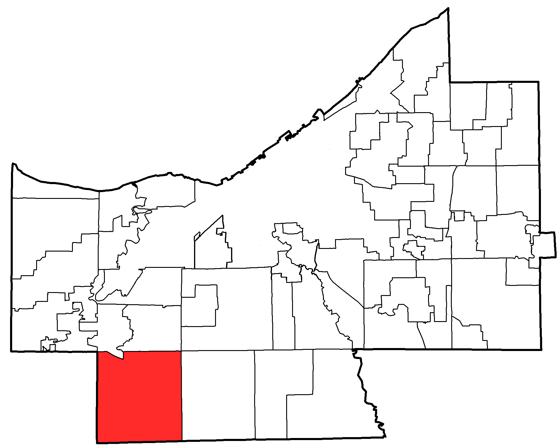
mapsize1 = 250px
map_caption1 = Location of Strongsville in Cuyahoga County
subdivision_type = Country
subdivision_name =United States
subdivision_type1 = State
subdivision_name1 =Ohio
subdivision_type2 = County
subdivision_name2 = Cuyahoga
subdivision_type3 =
subdivision_name3 =
subdivision_type4 =
subdivision_name4 =
government_type =Mayor-council
leader_title =Mayor
leader_name = Thomas Perciak
leader_title1 =
leader_name1 =
leader_title2 =
leader_name2 =
leader_title3 =
leader_name3 =
established_title = Township created
established_date = 1818
established_title2 = Village created
established_date2 = 1923
established_title3 = Incorporated
established_date3 = 1961
area_magnitude = 1 E8
area_total_km2 = 63.8
area_total_sq_mi = 24.6
area_land_km2 = 63.8
area_land_sq_mi = 24.6
area_water_km2 = 0
area_water_sq_mi = 0
area_water_percent = 0
area_urban_km2 =
area_urban_sq_mi =
area_metro_km2 =
area_metro_sq_mi =
population_as_of = 2000
population_note = census
population_total = 43858
population_density_km2 = 687.2
population_density_sq_mi = 1779.6
population_metro =
population_density_metro_km2 =
population_density_metro_sq_mi =
population_urban =
population_density_urban_km2 =
population_density_urban_sq_mi =
timezone = EST
utc_offset = -5
timezone_DST = EDT
utc_offset_DST = -4
latd = 41 |latm = 18 |lats = 46 |latNS = N
longd = 81 |longm = 49 |longs = 55 |longEW = W
elevation_m = 312
elevation_ft = 1026
postal_code_type = Zip code
postal_code = 44136, 44149
area_code = 440
website = http://www.strongsville.org
blank_name = FIPS code
blank_info = 39-75098GR|2
blank1_name = GNIS feature ID
blank1_info = 1065396GR|3
footnotes = Strongsville is a city in Cuyahoga County,Ohio ,United States . The population was 43,858 as of the 2000 Census. The current mayor, Thomas Perciak, was elected in November 2003 following the death of longtime mayor Walter F. Ehrnfelt in May. The city's nickname is 'Crossroads of the Nation,' as this is where theOhio Turnpike andInterstate 71 intersect.Geography
Strongsville is located at coor dms|41|18|46|N|81|49|55|W|city (41.312752, -81.831976)GR|1.
According to the
United States Census Bureau , the city has a total area of 24.6square mile s (63.8km² ), of which, 24.6 square miles (63.8 km²) of it is land and 0.04% is water. The east branch of the Rocky River enters Strongsville from North Royalton and exits into Berea. Valley Parkway parallels the river's northwesterly course. This portion of theCleveland Metroparks , named Mill Stream Run, includes Bonnie Park. Abutting the Rocky River, the recreation area offers visitors a pavilion, picnicking facilities, two small ponds, and several sport fields. Bonnie Park serves as a hub for hiking, bridle, and paved multi-purpose trails.Education
Strongsville High School serves well over 2,000 students in grades 9 through 12. Center and Albion middle schools (serving 7th and 8th graders), are about 70 and 35 years old, respectively. The city has eight elementary schools that serve pre-kindergarten through 6th grade: Allen, Chapman, Drake, Kinsner, Muraski, Surrarrer, Whitney, and Zellers. A private Catholic school, St. Joseph and John's, serves children through the 8th grade. A branch ofITT Technical Institute is located on Sprague Road.History
(For more information about the founding of Strongsville, go to [http://www.strongsville.org/content/founding.asp]
Strongsville officially became a township on February 25, 1818, a village in 1923, and was ultimately designated a city in 1961. Founded by settlers arriving in the newly purchased
Connecticut Western Reserve , the city was named after John Stoughton Strong, the group's leader. Many of the main streets in the city are named after other principle figures in the city's history, i.e. Howe, Drake, Shurmer, Whitney, et al.On
April 11 ,1965 , an F4 tornado hit Strongsville; seePalm Sunday tornado outbreak of 1965 .Demographics
As of the
census GR|2 of 2000, there were 43,858 people, 16,209 households, and 12,383 families residing in the city. Thepopulation density was 1,779.6 people per square mile (687.2/km²). There were 16,863 housing units at an average density of 684.2/sq mi (264.2/km²). The racial makeup of the city was 94.18% White, 1.26% African American, 0.05% Native American, 3.21% Asian, 0.01% Pacific Islander, 0.28% from other races, and 1.03% from two or more races. Hispanic or Latino of any race were 1.27% of the population.There were 16,209 households out of which 35.9% had children under the age of 18 living with them, 67.5% were married couples living together, 6.4% had a female householder with no husband present, and 23.6% were non-families. 19.9% of all households were made up of individuals and 7.0% had someone living alone who was 65 years of age or older. The average household size was 2.69 and the average family size was 3.13.
In the city the population was spread out with 26.3% under the age of 18, 6.2% from 18 to 24, 28.5% from 25 to 44, 27.6% from 45 to 64, and 11.4% who were 65 years of age or older. The median age was 39 years. For every 100 females there were 95.3 males. For every 100 females age 18 and over, there were 92.3 males.
The median income for a household in the city was $68,660, and the median income for a family was $76,964. Males had a median income of $54,988 versus $33,129 for females. The
per capita income for the city was $29,722. About 1.3% of families and 2.2% of the population were below thepoverty line , including 1.7% of those under age 18 and 3.7% of those age 65 or over.Points of interest
* Strongsville Commons and Clocktower
* Walter F. Ehrnfelt Covered Bridge
* Strongsville Historical Society
*Gardenview Horticultural Park
* Southpark Mall
* [http://www.ohiochannel.org/your_state/remarkable_ohio/marker_details.cfm?marker_id=785 The Pomeroy House] - A stop on the Underground Railroad.Geographic Location
North = Berea, Middleburg Heights
West = Columbia Township
Center = Strongsville
East = North Royalton
South = Brunswick, Brunswick Hills Township
Southeast = HinckleyReferences
External links
* [http://newteevee.com/2008/10/10/mccain-palin-supporters-gone-wild/ McCain-Palin Supporters Gone Wild]
* [http://www.strongsville.org The City of Strongsville Website]
* [http://www.strongsvillecofc.com/ Strongsville Chamber of Commerce]
* [http://mattsonworks.net/strongsville.html Strongsville Cemetery Records]
* [http://www.strongsville.org/content/historical_society.asp Strongsville Historical Society]
* [http://www.strongsville.org/content/history.asp History of Strongsville]
* [http://www.strongsville-ohio.net The Strongsville, Ohio Community Advocate] The handiest local reference guide available for the Strongsville, Ohio area. Updated daily.
* [http://www.ua-ohio.net/community/oldsite/other_communities-strongsville.htm Information About Strongsville Rec Center]
Wikimedia Foundation. 2010.