- Mann Township, Bedford County, Pennsylvania
-
Mann Township, Pennsylvania — Township — Map of Bedford County, Pennsylvania highlighting Mann Township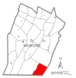 Map of Bedford County, Pennsylvania
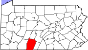
Country United States State Pennsylvania County Bedford Settled 1808 Incorporated 1876 Area – Total 35.9 sq mi (93 km2) Population (2000) – Total 481 – Density 13.4/sq mi (5.2/km2) Time zone Eastern (EST) (UTC-5) – Summer (DST) EDT (UTC-4) Area code(s) 814 Mann Township is a township in Bedford County, Pennsylvania, United States. The population was 481 at the 2000 census.
Contents
Geography
According to the United States Census Bureau, the township has a total area of 35.9 square miles (92.9 km²), all of it land.
Adjacent municipalities
- Southampton Township (west)
- Monroe Township (north)
- Union Township, Fulton County (east)
- Allegany County, Maryland (south)
Demographics
As of the 2000 census, there were 481 people, 191 households, and 141 families residing in the township. The population density was 13.4 people per square mile (5.2/km²). There were 385 housing units at an average density of 10.7/sq mi (4.1/km²). The racial makeup of the township was 99.17% White, 0.21% African American, 0.21% Asian, and 0.42% from two or more races.
There were 191 households out of which 29.3% had children under the age of 18 living with them, 61.3% were married couples living together, 6.8% had a female householder with no husband present, and 25.7% were non-families. 22.5% of all households were made up of individuals and 7.3% had someone living alone who was 65 years of age or older. The average household size was 2.52 and the average family size was 2.94.
In the township the population was spread out with 24.7% under the age of 18, 4.8% from 18 to 24, 27.9% from 25 to 44, 29.9% from 45 to 64, and 12.7% who were 65 years of age or older. The median age was 40 years. For every 100 females there were 103.0 males. For every 100 females age 18 and over, there were 100.0 males.
The median income for a household in the township was $28,929, and the median income for a family was $33,077. Males had a median income of $26,339 versus $17,813 for females. The per capita income for the township was $13,893. About 12.8% of families and 14.9% of the population were below the poverty line, including 16.3% of those under age 18 and 15.5% of those age 65 or over.
References
Municipalities and communities of Bedford County, Pennsylvania Boroughs Bedford | Coaldale | Everett | Hopewell | Hyndman | Manns Choice | New Paris | Pleasantville | Rainsburg | St. Clairsville | Saxton | Schellsburg | Woodbury
Townships Bedford | Bloomfield | Broad Top | Colerain | Cumberland Valley | East Providence | East St. Clair | Harrison | Hopewell | Juniata | Kimmel | King | Liberty | Lincoln | Londonderry | Mann | Monroe | Napier | Pavia | Snake Spring | South Woodbury | Southampton | West Providence | West St. Clair | Woodbury
Unincorporated
communitiesBreezewood | Chaneysville | Defiance | Loysburg | Mount Dallas | Osterburg | Riddlesburg | State Line
Coordinates: 39°47′30″N 78°23′29″W / 39.79167°N 78.39139°W
Categories:- Populated places established in 1808
- Townships in Bedford County, Pennsylvania


Wikimedia Foundation. 2010.