- Pennsylvania Route 546
-
PA Route 546

Route information Maintained by PennDOT Length: 3.51 mi[1] (5.65 km) Existed: 1928 – present Major junctions South end:  PA 346 in Otto Township
North end:  CR 45 at New York state line in Otto Township
Location Counties: McKean Highway system Roads in Pennsylvania
Interstate • US • State • Legislative←  PA 545
PA 547  →
→Pennsylvania Route 546 (designated by the Pennsylvania Department of Transportation as State Route 0546) is an 3.51-mile (5.65 km) long state highway in the northernmost regions of McKean County, Pennsylvania. The route, known locally as Oil Valley Road, begins at an intersection with Pennsylvania Route 346 in the community of Duke Center (located in Otto Township). The highway heads northward, through mountainous regions before crossing the state line and into New York, where it continues as Cattaraugus County Route 45 to New York State Route 16.
PA 546 was designated in the 1928 numbering of state highways in the commonwealth. The route was under construction and unpaved for two years afterward, and by 1930, the route was complete and has remained virtually intact since.
Contents
Route description
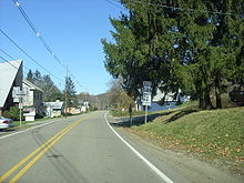 Route 546 heading northward from the Route 346 junction in Duke Center
PA 546 begins at an intersection with Pennsylvania Route 346 in the community of Duke Center. The highway, known locally as Oil Valley Road, progresses to the northeast, intersecting with a short connector back to PA 346 (Quadrant Route 9112).[2] Duke Center is small and PA 546 runs along the center of the community. The community and PA 546 run along the base of the 2,000 feet (610 m) mountain. PA 546 parallels the Knapp Creek, and after an intersecting with Galespie Hollow Road, the highway leaves Duke Center.[3]
Continuing northward, the highway enters the community of Oil Valley, which the road is named for. At an intersection with Bootleg Hollow, Knapp Creek turns off PA 546. A short distance later, the highway passes through several taller mountains, some reaching as high as 2,200 feet (670 m) tall.[3] The route crosses the state line and continues northward as Cattaraugus County Route 45, which heads northward to an intersection with New York State Route 16 in Knapp Creek, New York.[1]
History
Pennsylvania Route 546 began in the 1928 numbering of state highways in the commonwealth of Pennsylvania. The route was assigned at the time on its current alignment, but the highway was not completely constructed. At the time, the sections of PA 546 from the community of Duke Center to a location 2 miles (3.2 km) north were incomplete.[4] By 1929, this missing piece was completed, and was paved. However, the road was not complete, as there was an unpaved piece of PA 546 from that point[5] This unpaved area was finished by the next year.[6] PA 546, although, has remained intact in terms of alignment since its assignment in 1928.[7]
The lone bridge constructed along PA 546 was a concrete slab bridge over Knapp Creek. The community of Duke Center is the location of the bridge, which was constructed in 1970. The bridge is 27.887 feet (8.500 m) long, and holds up to 84 tons (77 metric tons). The bridge averages an annual average daily traffic count of 804 vehicles in a 2004 rating.[8]
Major intersections
The entire route is in Otto Township, McKean County.
Mile[3] Destinations Notes 0.00 PA 346 (Main Street)3.51 CR 45 (Duke Center Road)New York state line 1.000 mi = 1.609 km; 1.000 km = 0.621 mi See also
References
- ^ a b Yahoo! Inc. Yahoo! Maps – overview map of PA 546 (Map). Cartography by NAVTEQ. http://maps.yahoo.com/#mvt=m&lat=41.982494&lon=-78.488472&zoom=14&q1=41.953841%2C-78.481434&q2=41.999655%2C-78.505981. Retrieved March 26, 2009.
- ^ Pennsylvania Department of Transportation (2011). General Highway Map -McKean County, Pennsylvania (Map). Harrisburg, Pennsylvania. ftp://ftp.dot.state.pa.us/public/pdf/BPR_pdf_files/Maps/GHS/Roadnames/mckean_GHSN.PDF. Retrieved September 7, 2011.
- ^ a b c Google, Inc. Google Maps – overview map of PA 546 (Map). Cartography by Google, Inc. http://maps.google.com/maps?sourceid=navclient&ie=UTF-8&rlz=1T4ADBF_enUS232US232&q=from%3A%20Oil%20Valley%20Rd%20%4041.953385%2C%20-78.481026%20to%3A%20Oil%20Valley%20Rd%20%4041.999782%2C%20-78.505828&um=1&sa=N&tab=wl. Retrieved May 4, 2008.
- ^ Pennsylvania Department of Highways (1928). Map Showing Pennsylvania State Highways (Map).
- ^ Pennsylvania Department of Highways (1929). Map Showing Pennsylvania State Highways (Map).
- ^ Pennsylvania Department of Highways (1930). Map Showing Pennsylvania State Highways (Map).
- ^ Pennsylvania Department of Transportation (2009). Pennsylvania (Map). Cartography by Pennsylvania Department of Transportation.
- ^ "Structure Number: 420546002000000". United States Department of Transportation. 2007. pp. 1. http://nationalbridges.com/nbi_record.php?StateCode=42&struct=420546002000000. Retrieved June 5, 2009.
External links
Categories:- State highways in Pennsylvania
- Transportation in McKean County, Pennsylvania


Wikimedia Foundation. 2010.