- Cheltenham Township, Montgomery County, Pennsylvania
-
Cheltenham Township Home Rule Municipality Seal of Cheltenham TownshipMotto: "Salubritas et Eruditio" (Health and Education) Country United States State Pennsylvania County  Montgomery
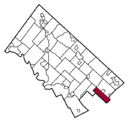
Elevation 157 ft (47.9 m) Coordinates 40°04′00″N 75°06′59″W / 40.0666667°N 75.11639°W Area 9.0 sq mi (23.3 km2) - land 9.0 sq mi (23 km2) - water 0.0 sq mi (0 km2), 0% Population 36,793 (2010) Density 4,083.1 / sq mi (1,576.5 / km2) Founded 1682 Timezone EST (UTC-5) - summer (DST) EDT (UTC-4) Postal code 19012, 19027, 19038, 19095 Area code 215 Website: http://www.cheltenhamtownship.org Cheltenham Township is a home rule municipality in Montgomery County, Pennsylvania, United States. Although it retains the word "Township" in its official name, it has been governed by a home rule charter since 1977 and is therefore not subject to the Pennsylvania Township Code.[1] The population was 36,793 at the 2010 census, making it the third most populous township in Montgomery County. It is bordered by the City of Philadelphia to the East and South, Abington Township, Montgomery County, Pennsylvania to the North, Springfield Township, Montgomery County, Pennsylvania to the West.[2]
Contents
History
Cheltenham was established in 1682 by 15 Quakers from Cheltenham, England, including Richard Wall and Tobias Leech, who purchased 4,070 acres (16.5 km2) of land from William Penn.[3][4]
The La Mott section of the township was the site of Camp William Penn, the training grounds of the first African-American troops ever enlisted into the United States Army during the American Civil War. These soldiers were at General Lee's surrender, helped hunt down John Wilkes Booth and were the only African-American soldiers to carry President Lincoln's casket.[citation needed]
The USCT (United States Colored Troops) 3rd Regiment were the first to be trained at Camp William Penn. It is tradition that soldiers have a grand parade before leaving for war, but Philadelphia was partially a racist community at that time and the government believed that a parade might cause a riot, so it was cancelled. The leader of the Camp (Colonel Louis Wagner) was furious and made sure the next regiment to come through would have a parade.
Cheltenham became a township of the first class in 1900. In 1976, it passed a home rule charter that took effect in 1977.
There are many books about Cheltenham Township's prestigious history.
- A History of Cheltenham Township by Elaine Rothschild
- Images of America Cheltenham Township by Old York Road Historical Society
- Remembering Cheltenham Township by Donald Scott Sr.
- Making Marathon: A History of Early Wyncote by Thomas J. Wieckowski
Geography
Cheltenham is a residential township in Montgomery County, southeastern Pennsylvania. It borders Philadelphia and is 16 km (10 mi) northeast of the city's center. It also borders Abington Township on the north side and Springfield Township on the west side.
According to the United States Census Bureau, the township has a total area of 9.0 square miles (23 km2). The area consists of rolling hills and also has a few streams running through it, most notably the Tookany Creek. It includes the census-designated places of Cheltenham, Elkins Park, Wyncote, Glenside, Melrose Park, La Mott and Laverock.Demographics
Historical populations Census Pop. %± 1930 15,731 — 1940 19,082 21.3% 1950 22,854 19.8% 1960 35,990 57.5% 1970 40,066 11.3% 1980 35,509 −11.4% 1990 34,923 −1.7% 2000 36,875 5.6% 2010 36,793 −0.2% www.dvrpc.org/data/databull/rdb/db82/appedixa.xls.</ref> As of the 2010 census, Cheltenham Township was 57.4% White, 31.1% Black or African American, 0.2% Native American, 7.7% Asian, and 2.5% were two or more races. 3.9% of the population were of Hispanic or Latino ancestry [2].
As of the census[5] of 2000, there were 36,875 people, 14,346 households, and 9,640 families residing in the township. The population density was 4,083.1 people per square mile (1,576.7/km²). There were 14,897 housing units at an average density of 1,649.5 per square mile (637.0/km²). The racial makeup of the township was 66.45% White, 24.61% African American, 0.12% Native American, 6.44% Asian, 0.06% Pacific Islander, 0.79% from other races, and 1.53% from two or more races. Hispanics or Latinos of any race were 1.99% of the population.
30.4% of the townships households have children under the age of 18 living with them, 53.4% are headed by married couples living together, 10.6% had a female householder with no husband present, and 32.8% were non-families. 27.6% of all households were made up of individuals and 12.5% had someone living alone who was 65 years of age or older. The average household size was 2.47 and the average family size was 3.05.
The age distribution was 22.8% under 18, 8.5% from 18 to 24, 25.9% from 25 to 44, 24.1% from 45 to 64, and 18.6% who were 65 or older. The median age was 40 years. For every 100 females there were 86.3 males. For every 100 females age 18 and over, there were 81.0 males.
The median income for a household in the township was $61,713, and the median income for a family was $76,792. Males had a median income of $50,564 versus $36,439 for females. The per capita income for the township was $31,424. About 3.0% of families and 5.1% of the population were below the poverty line, including 6.5% of those under age 18 and 3.2% of those age 65 or over.
Politics and government
Presidential elections results Year Republican Democrat 2008 19.3% 4,043 80.0% 16,728 2004 22.7% 4,690 77.0% 15,866 2000 22.0% 4,106 76.0% 14,169 1996 23.2% 4,040 70.1% 12,190 1992 24.3% 4,723 65.0% 12,624 Cheltenham Township does not have a mayor. Rather it is governed by a Board of Commissioners, who are elected one from each of the township's seven wards. A President of the Board is rotated between these commissioners, and serves as the head of government. Paul Greenwald is the current Board President. A school board, led by Tina Viletto, is in charge of the school district.
The township is in the Second Congressional District (represented by Rep. Chaka Fattah), and Pennsylvania's 154th Representative District (represented by Rep. Lawrence Curry). Prior to the 2000 census, it was in the 13th congressional district with the rest of Montgomery County. It is also in Pennsylvania's 4th Senatorial District
Education
The Cheltenham Township School District serves the township. There are seven public schools and a number of private schools. Public schools include Cheltenham Elementary School (k-4), Myers Elementary School (k-4), Glenside Elementary School (k-4), Wyncote Elementary School (k-4), Elkins Park School (5-6), Cedarbrook Middle School (7-8), and Cheltenham High School (9-12).[3]
The largest private high school in Cheltenham Township is Bishop McDevitt High School (9-12) which is under the Roman Catholic Archdiocese of Philadelphia.
The section of Elkins Park in Cheltenham is the former home of Tyler School of Art, a conceptual fine-arts school that is part of Temple University. Cheltenham is also home to Arcadia University (formerly known as Beaver College), Salus University (formerly known as The Pennsylvania College of Optometry), Westminster Theological Seminary, Gratz College and Reconstructionist Rabbinical College, the only seminary affiliated with Reconstructionist Judaism.
Libraries
Cheltenham Township has four libraries which are the East Cheltenham Free Library, Elkins Park Free Library, La Mott Free Library, and the Glenside Free library.
Transportation
Three SEPTA Regional Rail line stations are located wholly within the township. The stations carry the names of the neighborhoods in which they are located: Elkins Park; Glenside; and Melrose Park. Two additional stations, (Jenkintown-Wyncote and Cheltenham), straddle the township's border.
Beginning on January 31, 2005, Cheltenham Township partnered with Abington Township to launch a shared transit service. The Cheltenham Transit Service will operate on Tuesdays, Thursdays and Saturdays according to the same route and timetable as the current schedule. A new bus will be used for the service since Laidlaw Transit Service will be the new contractor. All other policies and procedures will remain the same. The bus runs in Abington Township on Mondays, Wednesdays, and Fridays.
The addition of Saturday to the Cheltenham Transit Service schedule offers riders new flexibility in their weekend travels. Although the change will result in a net reduction in service, Township officials consider this option preferable to eliminating the transit bus altogether.
Major Roads in Cheltenham Township
Cheltenham Avenue is a major roadway and is an easy access point to many of the other roadways like Pennsylvania Route 611 and Pennsylvania Route 309. It is also the Border between Cheltenham Township, Montgomery County, Pennsylvania and the City of Philadelphia, Philadelphia County, Pennsylvania. Cheltenham Avenue ends on the westside at Paper Mill Road in Wyndmoor, Pennsylvania which is part of the Springfield Township.
 Pennsylvania Route 73 is one of the major roadways in Cheltenham Township, known as 'Church Road' and 'Township Line Road' because it is the border line between Cheltenham and Abington Townships
 Pennsylvania Route 309 starts in Cheltenham Township and serves as a major highway. It goes through many townships and ends up in PA 29 in Noxen Township
 Pennsylvania Route 152 starts in Cheltenham Township and is known as 'Limekiln Pike.' It ends on the north end of Pennsylvania Route 309 in Telford, PA
 Pennsylvania Route 611 starts in Philadelphia and runs through Cheltenham Township as Old York Road. It is the main access road to Willow Grove in Abington and Upper Moreland Townships
Notable people
- Michael Brecker (saxophonist)
- Randy Brecker (jazz, rock, and R&B trumpeter)
- Michael Stuart Brown (American physician, geneticist, and Nobel laureate in Physiology or Medicine)
- Jay Cooke (financier - had his 'country estate' in Chelten Hills)
- Bill Cosby (comedian)
- Rebecca Creskoff (American actress)
- Cyrus H.K. Curtis (founder of the Curtis Publishing Company, which published The Saturday Evening Post and Ladies Home Journal)
- Reggie Jackson (Hall of Fame baseball player, Actor - grew up in township)
- Paul Westhead (NBA championship-winning coach, taught English at Cheltenham High School in 1960's)
- George Horace Lorimer (longtime editor of The Saturday Evening Post)
- Edgar Lee Masters (Lawyer and author of the Spoon River Anthology – spent final years and died in Elkins Park.)
- Mark Levin (conservative talk radio host)
- Mary Ellen Mark (photographer)
- Lucretia Coffin Mott (prominent feminist, abolitionist, and Quaker)
- Benjamin Netanyahu (Currently serving his second term as Israeli prime minister - lived in township during high school)
- Yonatan Netanyahu (Israeli war hero who died saving Jewish hostages in Operation Entebbe)
- Ezra Pound (poet - grew up in township)
- Kate Vrijmoet (artist - grew up in township)
- David Uosikkinen (drummer for rock band The Hooters)
- John Wanamaker (businessman sometimes called the father of the department store - had a second home in the township)
- George Dunton Widener (a Philadelphia businessman who died in the sinking of the Titanic)
Miscellaneous
- Cheltenham has its own Public-access television cable TV channel, Channel 42 (Cheltenham School District Broadcasting) on Comcast Cablevision.
- Cheltenham is twinned with - and named after - Cheltenham, United Kingdom.
- The Fox sitcom "'Til Death" is set in Cheltenham.[citation needed]
- The movie "The In Crowd" was filmed partly at Cheltenham High School.[citation needed]
Fire services
The Cheltenham Township Fire Department consists of 5 all volunteer fire companies.
- Glenside Fire Company
- La Mott Fire Company
- Elkins Park Fire Company
- Cheltenham Hook & Ladder Company
- Ogontz Fire Company
Points of interest
- Curtis Hall Arboretum - Located at the intersection of Greenwood Avenue and Church Road, Curtis Hall is home to Concerts in the Park over the summer, and the Community Harvest Festival, held annually on the second Saturday in October. Curtis also features many acres of fields, and a dog walking park.
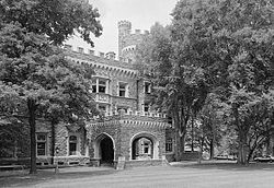
- Grey Towers Castle - a National Historic Landmark designed by Horace Trumbauer and home to Arcadia University - this historic castle in Glenside was designated a National Historic Landmark in 1985, and was built in 1893.
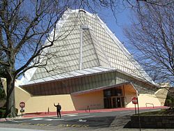
- Beth Sholom Synagogue - a National Historic Landmark designed by Frank Lloyd Wright. Beth Shalom, which means "House of Peace" in Hebrew is one of the most recognizable structures in Cheltenham Township.
- Richard Wall House - placed on the National Register of Historical Places 1979, the Wall House was built in 1683. It offers tours daily, run by the Cheltenham Township Historical Commission.
- Lynnewood Hall - Designed by Horace Trumbauer for Peter Arrell Brown Widener - Considered the largest surviving mansion of the Gilded Age in he Philadelphia Area, this was the home of Peter A.B. Widener.
- Elkins Estate - The home of William L. Elkins, who was a successful businessman with the Pennsylvania Railroad and SEPTA.
References
- ^ Pennsylvania Code Title 346, Sec. 21.1-101 et seq.
- ^ americantowns.com
- ^ Jones, Arthur Hosking. Cheltenham Township. A Sociological Analysis of a Residential Suburb. Philadelphia: University of Pennsylvania Press. 1940. 173 pages.
- ^ Anonymous. A Brief History of Cheltenham Township. [1]. Accessed 1/7/06.
- ^ "American FactFinder". United States Census Bureau. http://factfinder.census.gov. Retrieved 2008-01-31.
External links
- Cheltenham Township
- School District of Cheltenham Township
- Art: Xanthus Russell Smith (1839-1929) Mather's Cottage, at Cheltenham (Montgomery County), 1880
- Cheltenham Township Fire Department
- Lynnewood Hall
- The Elkins Estate
Communities Educational Institutions National Historic Sites Beth Sholom Synagogue • Curtis Hall Arboretum • Wall House • Grey Towers Castle • St. Paul's Episcopal Church • Milmoral • Camptown Historic District • Rowland House • Elkins Railroad Station • Glenside Memorial HallFamous People See also Pennsylvania's 2nd congressional district • Elkins Estate • Lynnewood HallMajor Roads Regional Rail Stations Infrastructure Categories:- Home Rule Municipalities in Pennsylvania
- Populated places in Montgomery County, Pennsylvania
Wikimedia Foundation. 2010.


