- Delaware Water Gap, Pennsylvania
-
Borough of Delaware Water Gap Settlement 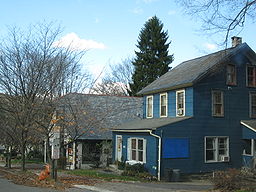 Delaware Water Gap, Pennsylvania
Country United States State Pennsylvania County Monroe Elevation 400 ft (121.9 m) Coordinates 40°58′55″N 75°08′33″W / 40.98194°N 75.1425°W Area 1.7 sq mi (4.4 km2) - land 1.7 sq mi (4 km2) - water 0.0 sq mi (0 km2), 0% Population 744 (2000) Density 427.4 / sq mi (165 / km2) Timezone EST (UTC-5) - summer (DST) EDT (UTC-4) ZIP Code 18327 Area code 570 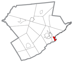 Location of Delaware Water Gap in Monroe County
 Location of Delaware Water Gap in Pennsylvania
 Location of Pennsylvania in the United States
Delaware Water Gap is a borough in Monroe County, Pennsylvania, United States. It is located adjacent to the Delaware Water Gap, the pass through which the Lackawanna Corridor and Interstate 80 run across the Pennsylvania-New Jersey border along the Delaware River.
The population of Delaware Water Gap was 744 at the 2000 census.
Contents
Geography
Delaware Water Gap is located at 40°58′55″N 75°8′33″W / 40.98194°N 75.1425°W (40.982028, -75.142624)[1].
According to the United States Census Bureau, the borough has a total area of 1.7 square miles (4.4 km2), all of it land.
Demographics
As of the census[2] of 2000, there were 744 people, 345 households, and 192 families residing in the borough. The population density was 427.4 people per square mile (165.1/km²). There were 362 housing units at an average density of 207.9 per square mile (80.3/km²). The racial makeup of the borough was 92.61% White, 4.03% African American, 0.13% Native American, 1.21% Asian, 1.08% from other races, and 0.94% from two or more races. Hispanic or Latino of any race were 4.97% of the population.
There were 345 households out of which 24.3% had children under the age of 18 living with them, 42.9% were married couples living together, 8.1% had a female householder with no husband present, and 44.1% were non-families. 31.9% of all households were made up of individuals and 7.2% had someone living alone who was 65 years of age or older. The average household size was 2.16 and the average family size was 2.73.
In the borough the population was spread out with 19.0% under the age of 18, 10.1% from 18 to 24, 36.2% from 25 to 44, 24.2% from 45 to 64, and 10.6% who were 65 years of age or older. The median age was 36 years. For every 100 females there were 97.3 males. For every 100 females age 18 and over, there were 93.3 males.
The median income for a household in the borough was $37,708, and the median income for a family was $45,795. Males had a median income of $31,786 versus $26,083 for females. The per capita income for the borough was $21,641. About 8.1% of families and 8.8% of the population were below the poverty line, including 10.9% of those under age 18 and 3.4% of those age 65 or over.
Public education
The Borough is served by the Stroudsburg Area School District.
Happenings
- Each year in September, the Delaware Water Gap Celebration of the Arts Festival takes place. The festival showcases world-renowned jazz artists, sculptors, and painters that live in or around the town.
See also
References
- ^ "US Gazetteer files: 2010, 2000, and 1990". United States Census Bureau. 2011-02-12. http://www.census.gov/geo/www/gazetteer/gazette.html. Retrieved 2011-04-23.
- ^ "American FactFinder". United States Census Bureau. http://factfinder.census.gov. Retrieved 2008-01-31.
Municipalities and communities of Monroe County, Pennsylvania Boroughs Delaware Water Gap | East Stroudsburg | Mount Pocono | Stroudsburg

Townships Barrett | Chestnuthill | Coolbaugh | Eldred | Hamilton | Jackson | Middle Smithfield | Paradise | Pocono | Polk | Price | Ross | Smithfield | Stroud | Tobyhanna | Tunkhannock
CDPs Unincorporated
communitiesBartonsville | Canadensis | Cresco | Effort | Gilbert | Jonas | Long Pond | Marshalls Creek | Pocono Manor | Pocono Summit | Skytop | Swiftwater | Tannersville | Tobyhanna
Categories:- Populated places established in 1793
- Delaware Water Gap
- Boroughs in Monroe County, Pennsylvania


Wikimedia Foundation. 2010.