Meadowbrook (SEPTA station)

Meadowbrook (SEPTA station)
Meadowbrook
SEPTA regional rail
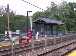
Meadowbrook Station.JPG
Meadowbrook Station
Station statistics
Address Mill Road & Lindsay Avenue
Abington, PA
Coordinates 40°06′41″N 75°05′33″W / 40.1114°N 75.0925°W / 40.1114; -75.0925Coordinates: 40°06′41″N 75°05′33″W / 40.1114°N 75.0925°W / 40.1114; -75.0925
Lines
  West Trenton Line
Platforms 2 side platforms
Tracks 2
Parking 90
Other information
Owned by SEPTA
Fare zone 3
Services
Preceding station   SEPTA   Following station
West Trenton Line

Meadowbrook is a station along the SEPTA West Trenton Line (SEPTA) to Ewing, New Jersey. It is located at Mill Road & Lindsay Lane in Abington, Pennsylvania. The station has off-street parking. The station building was destroyed by a fire in April 1995 and was replaced by the bus shelter type of facility that currently serves as the waiting area.

External links


Wikimedia Foundation. 2010.

Игры ⚽ Поможем написать реферат

Look at other dictionaries:

  • Meadowbrook — may refer to: Contents 1 Places 1.1 Australia 1.2 United States …   Wikipedia

  • Crestmont (SEPTA station) — Crestmont SEPTA regional rail Station statistics Address Rubicam R …   Wikipedia

  • Noble (SEPTA station) — Noble SEPTA regional rail Noble Station Station statistics Add …   Wikipedia

  • National Register of Historic Places listings in Montgomery County, Pennsylvania — Location of Montgomery County in Pennsylvania This is a list of the National Register of Historic Places listings in Montgomery County, Pennsylvania. This is intended to be a complete list of the properties and districts on National Register of… …   Wikipedia

  • Narberth, Pennsylvania — Coordinates: 40°00′27″N 75°15′44″W / 40.0075°N 75.26222°W / 40.0075; 75.26222 …   Wikipedia

  • Red Line (UTA Trax) —      Red Line A university bound train near the Frank E. Moss Federal Courthouse …   Wikipedia

  • North Hills, Pennsylvania — North Hills is an unincorporated community in Abington, Springfield, and Upper Dublin townships in Montgomery County, Pennsylvania, United States. It is served by the 19038 zip code. It is a lesser developed town than their neighbor, Glenside. It …   Wikipedia

  • National Register of Historic Places listings in Northwest Philadelphia — Location of Northwest Philadelphia in Philadelphia This is a list of the National Register of Historic Places listings in Northwest Philadelphia. This is intended to be a complete list of the properties and districts on the National Register of… …   Wikipedia

  • North Wales, Pennsylvania — Coordinates: 40°12′39″N 75°16′30″W / 40.21083°N 75.275°W / 40.21083; 75.275 …   Wikipedia

  • Oreland, Pennsylvania — Coordinates: 40°06′52″N 75°10′48″W / 40.11444°N 75.18°W / 40.11444; 75.18 …   Wikipedia

Share the article and excerpts

Direct link
Do a right-click on the link above
and select “Copy Link”