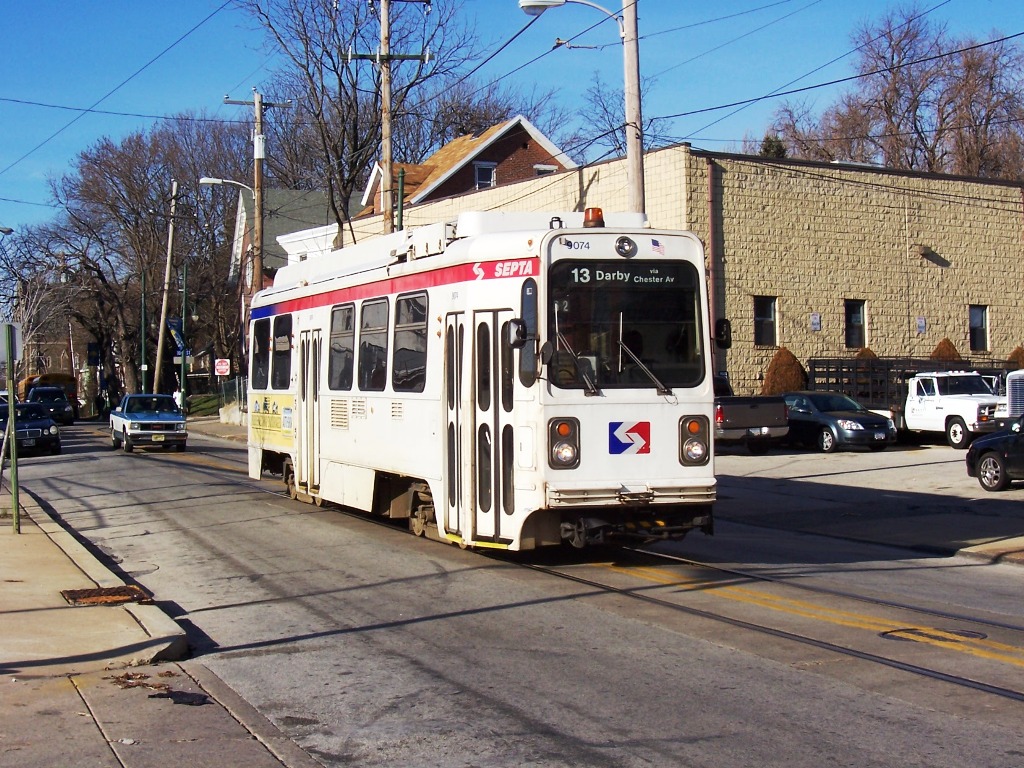
- SEPTA Subway–Surface Trolley Lines
Infobox rail line
name = color box|#SEPTA color|Subway-Surface Subway–Surface Trolley Lines
image_width = 250px
caption = #9074 operates on the #13 line in Darby, PA.
type = Trolley
system =
status =
locale =Philadelphia , Yeadon, and Darby, PA
start = Overbrook (Rt 10)
Darby (Rt 11/13)
Angora (Rt 34)
Eastwick (Rt 36)
end = Juniper (all lines)
stations = 8 total underground stations, 8 major surface stations
routes = Routes 10, 11, 13, 34, and 36
ridership =
open = 1906
close =
owner =SEPTA
operator =
character = Underground and surface
stock =
linelength =
tracklength =
notrack =
gauge = RailGauge|62.25
el =Overhead lines
speed =
elevation =
Subway-Surface|The Subway–Surface Trolley Lines are five SEPTA trolley lines that operate on public streets in
Philadelphia and Delaware County,Pennsylvania , and also operate in a sharedrapid transit andlight rail subway in Center City, Philadelphia.The system is comparable to
Boston 's Green Line andSan Francisco 'sMuni Metro , which use longer, articulated LRT vehicles.Starting from their eastern end in downtown Philadelphia, the lines run in a tunnel under Market Street. All five routes stop at underground stations at Juniper, 15th Street, 19th Street, 22nd Street, 30th Street, and 33rd Street. From 15th to 30th Streets, they run in the same tunnel as SEPTA's
Market–Frankford Line , with the rapid-transit trains on the inner tracks and the subway–surface trolleys on the outer ones.Passengers may transfer free of charge to the Market–Frankford Line at Juniper/13th, 15th, and 30th Streets and to the
Broad Street Line at 15th Street. Connections to theSEPTA Regional Rail are also available. Underground passageways connect the 13th and 15th Street Stations toMarket East Station andSuburban Station .The 30th Street trolley station is across the street from the 30th Street railroad station that serves SEPTA and Amtrak trains. An underground passageway that connects these stations is currently closed.
The Route 10 line surfaces on 36th Street just south of Market Street, then heads northwest on surface streets. The other four lines make underground stops at 36th and Sansom Streets and at 37th and Spruce Streets, surface at the 40th St Portal near 40th Street and Baltimore Avenue, and then head southwest on surface streets.
History
The Subway–Surface lines are remnants of the far more extensive streetcar system that developed in Philadelphia after the arrival of electric trolleys in 1892. Several dozen traction companies were consolidated in 1906 into the Philadelphia Rapid Transit Company. The PRT funneled the West Philadelphia lines into subway tunnels as they approached the city center. After the PRT declared bankruptcy in 1939, it was reopened as the Philadelphia Transportation Company (PTC), which was absorbed into SEPTA in 1968.cite web| url=http://www.studio34yoga.com/trolley.shtml | title="Studio 34's Eponymous Trolley, or, A Short History of Route 34" | accessdate=2008-03-11 ]
In October 2006, University of Pennsylvania's class of 1956 funded the construction of an innovative portal for one of the eastbound entrances of the 37th and Spruce station: a replica of a Peter Witt trolley of the kind manufactured by
J. G. Brill and Company from 1923–26. Operated by thePhiladelphia Transportation Company until 1956, these trolleys brought university students to the campus and toCenter City, Philadelphia . Routes 11, 34 and 37 ran through the Penn campus on Woodland Avenue and Locust Streets for nearly 65 years. In 1956, the trolley route was buried to enable the university to unify its campus. Woodland Avenue and Locust Street became pedestrian walkways.Routes
Stations
All stations are in Philadelphia and western suburbs. Stations only on Route 10 are shown in gray.
ee also
*
SEPTA City Transit Division surface routes
*West Philadelphia Streetcar Suburb Historic District External links
* [http://www.septa.org/service/sub_schedules.html SEPTA subway and trolley schedules]
* [http://www.MetroMapr.com/Transit.aspx?city=Philadelphia MetroMapr.com | Interactive Google Maps of the transit systems in Boston, DC, and Philadelphia with search.]
* [http://www.facilities.upenn.edu/mapsBldgs/view_map.php3?id=194 Map of subway surface lines in West Philadelphia]
*http://www.phillytrolley.org
* [http://www.publictransit.us/ptlibrary/Railopenings.pdf U.S. Urban Rail Transit Lines Opened From 1980] (PDF )References
Wikimedia Foundation. 2010.
