- Norristown High Speed Line
-

Norristown High Speed Line
SEPTA N-5 car #144 enters the Gulph Mills Station in Upper Merion, Pennsylvania.Overview Type Interurban System SEPTA Suburban Division Status Operational Locale Delaware and Montgomery Counties, Pennsylvania Termini 69th Street Terminal (south)
Norristown Transportation Center (north)Stations 22 Services - Local
- Norristown Express
- Hughes Park Express
- Norristown Limited
Daily ridership 8,530 (average weekday FY 2010)[1] Operation Opened 1907 Operator(s) SEPTA Character Surface (grade separated) Rolling stock Asea-Amtrak (Asea Brown Boveri-Morrison-Knudsen) Type N-5 LRV (25) Technical Line length 13.4 miles (21.6 km) No. of tracks 1–3 Track gauge 4 ft 8 1⁄2 in (1,435 mm) Electrification Third rail Route number 100 (former) Route map Legend


SEPTA Manayunk/Norristown Line 


Norristown Trans Ctr 

Schuylkill River 
Bridgeport DeKalb Street 
 I-276 (PA Turnpike)
Hughes Park 
Gulph Mills  I-76 (Schuylkill Expwy)
Matsonford County Line 
SEPTA Paoli/Thorndale Line / Amtrak Radnor  I-476
I-476Villanova Stadium – Ithan Avenue Garrett Hill Roberts Road Bryn Mawr Haverford Ardmore Avenue 
Ardmore Junction Wynnewood Road Beechwood–Brookline Penfield Township Line Road Parkview 


69th Street Terminal 

Routes 101/102 
Market–Frankford Line This route map:
The Norristown High Speed Line (NHSL) is an interurban line system operated between Upper Darby and Norristown, Pennsylvania, USA by SEPTA. The rail line runs entirely on its own right-of-way, inherited from the original Philadelphia and Western Railroad line (still referred to by locals as the "old P&W" and Route 100).
The Norristown High Speed Line is unique in its combination of transportation technologies. Originally chartered as a steam railroad, the line is fully grade separated, collects power from a third rail, and has high-level platforms common to rapid transit systems, but has onboard fare collection, mostly single-car operation, and frequent stops more common to light rail systems. Previously, the Norristown High Speed Line was considered to be a light rail line, according to a 2008 SEPTA budget report;[2] however, the line is currently considered a heavy rail interurban line, according to a 2009 SEPTA business plan.[3]
The line was formerly known simply as Route 100 but was officially changed to its current name in September 2009 as part of a customer service initiative by SEPTA.[4]
Contents
History
See also: Philadelphia and Western RailroadThe Norristown High Speed Line began service in 1907 as the Philadelphia and Western Railroad (P&W), which ran from the present 69th Street Terminal in Upper Darby, Pennsylvania to a converted farmhouse station in Strafford, Pennsylvania. In 1911, the line was extended .47 mile west to a new Strafford P&W station adjacent to the Pennsylvania RR's Strafford station, allowing easy interchange between the two lines. In 1912, a 6.2-mile branch was constructed from Villanova Junction, .33 mile west of the existing Villanova station, to Norristown.[5] When the newly-built branch quickly attracted more ridership than the Strafford main line, the Norristown section became the main line and the Strafford stretch was demoted to branch status; in the mid 1930s, the Strafford spur was narrowed to a single track for its last 1.74 miles between the Wayne-St. Davids and Strafford stations, while the Norristown line got a sleek new art deco terminus at Main and Swede Streets.[5]
Lehigh Valley connection
From Norristown, the P&W RR connected its tracks with Lehigh Valley Transit Liberty Bell Route to provide direct electric train service from 69th St. Terminal to Allentown, Pennsylvania. However, in 1951, the Lehigh Valley Transit Company ended its service on the Liberty Bell Route, and in 1953 the company ended all its remaining rail service. Two years later, the P&W RR was taken over by the Philadelphia Suburban Transportation Company (PSTC), which was more popularly known as the Red Arrow Lines. In 1956, the PSTC abandoned the original branch between Villanova to Strafford, leaving only electric MU trains between 69th Street and Norristown, as it is today.[6] The PSTC was absorbed into SEPTA in 1969,[7] eliminating the original railroad charter and immediately becoming the "Norristown High-Speed Line Trolley", officially known as Route 100.
Ridership
Ridership on the Norristown line peaked in 1973 at 2,860,000 annual linked trips, and again in 1980 with 2,579,000 annual linked trips. Ridership statistics for fiscal years 2000 and later are from SEPTA Annual Service Plans. Data for years 1972 to 1997 are from the SEPTA 1997 Ridership Census. There may be some discrepancy in how the ridership is reported since the Annual Service Plans report total unlinked trips, while the ridership census uses linked trips, which may exclude passengers transferring from other lines.
Station Names
Effective June 14, 2010, SEPTA changed the names of four stations to reflect the streets on which they were located.
Station list
Mileage Station Zone Township County 0.0 69th Street Terminal 
1 Upper Darby Delaware 0.7 Parkview 1.4 Township Line Road Haverford 1.9 Penfield 
2.5 Beechwood–Brookline 3.1 Wynnewood Road 3.4 Ardmore Junction 1 and 2 3.9 Ardmore Avenue 4.5 Haverford 5.4 Bryn Mawr Radnor 5.9 Roberts Road 2 6.4 Garrett Hill 6.8 Stadium – Ithan Avenue 7.0 Villanova 7.9 Radnor 8.6 County Line Lower Merion Montgomery 9.4 Matsonford 10.3 Gulph Mills Upper Merion 11.0 Hughes Park 12.3 DeKalb Street Bridgeport 12.8 Bridgeport 13.4 Norristown Transportation Center Norristown Most stations (except terminals) are request stops. Passengers wishing to board must push a button at the station, which activates a light visible to the engineer. If the train is scheduled to stop at the station (see below), it will stop. Detraining passengers must press a button onboard to request the train to stop.
Service
 Route 100 map from 1974
The fare as of as of 2010[update] is $2.00 cash on board, or $1.55 using pre-purchased tokens, with an additional $0.50 zone charge when traveling in more than one zone. The service runs seven days a week, from about 5:00 AM in the morning to 1:00 AM at night.
Local trains from 69th Street to Norristown stop at all 22 stations, and the trip lasts approximately 32 minutes. Occasionally, local trains may run only between 69th Street and Bryn Mawr, stopping at ten stations.
During weekday peak periods (6:00–9:00 AM, 2:15–6:45 PM), the Norristown High Speed Line features express and limited services, which stop only at select stations, therefore decreasing travel time between 69th Street and Norristown. Norristown Express service, which is noted by red destination signs, travels between 69th Street and Norristown in approximately 26 minutes, and stops at 17 stations. Hughes Park Express service, which is noted by green destination signs, travels between 69th Street and Hughes Park in approximately 22 minutes, stopping at 16 stations. Norristown Limited service, which is noted by blue destination signs, travels between 69th Street and Norristown in approximately 22 minutes, stopping at only eight stations. There is also one southbound Limited trip on Saturdays. All trains share the same two tracks, so a limited leaving Norristown, for example, will be immediately followed by a local, which stops at more stations, and therefore is spaced farther from the previous train. The next limited will catch up with it. Similarly, a local may leave Bryn Mawr right after an express stops there, and gets to 69th St. just before the next express or limited catches up with it.
Local Norristown Express Hughes Park Express Norristown Limited 69th Street Terminal 69th Street Terminal 69th Street Terminal 69th Street Terminal Parkview — — — Township Line Rd. — — — Penfield Penfield — — Beechwood–Brookline — Beechwood–Brookline — Wynnewood Road — Wynnewood Road — Ardmore Junction Ardmore Junction Ardmore Junction Ardmore Junction Ardmore Avenue — Ardmore Avenue — Haverford — Haverford — Bryn Mawr Bryn Mawr Bryn Mawr — Roberts Road Roberts Road Roberts Road — Garrett Hill Garrett Hill Garrett Hill — Ithan Av. Ithan Av. Ithan Av. — Villanova Villanova Villanova — Radnor Radnor Radnor Radnor County Line County Line County Line — Matsonford Matsonford Matsonford — Gulph Mills Gulph Mills Gulph Mills Gulph Mills Hughes Park Hughes Park Hughes Park Hughes Park DeKalb St. DeKalb St. — DeKalb St. Bridgeport Bridgeport — Bridgeport Norristown Norristown — Norristown Proposed extension to King of Prussia
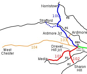 Map of the Red Arrow Lines showing the current Norristown High Speed Line (blue); the former branch to Strafford is dashed, as well as former trolley Routes 101–104 (red, still in use, and orange, disbanded)
There is a proposal[update] to extend the Norristown High Speed Line to serve the King of Prussia Mall and Valley Forge office parks. The 4.9-mile (7.9 km) extension would branch from the existing line just north of the Hughes Park station, continue westward along the Norfolk Southern Morrisville Line right-of-way, and then northward through King of Prussia to Valley Forge. This extension would include 2.2 miles (3.5 km) of elevated track.
It is projected that this extension would attract an additional 3,800 daily riders. SEPTA already has enough N-5 rail vehicles to cover this extended service. It would also complement the planned[update] Schuylkill Valley Metro line that will have a "Cross-County" segment that will also use the Norfolk Southern freight line from King of Prussia to Glenloch near Exton.
Fiscal year Average weekday Annual passengers FY 2005 8,801 2,512,690 FY 2004 8,428 2,463,500 FY 2003 7,925 2,491,074 FY 2000 9,250 3,046,927 Fiscal year Annual linked trips Fiscal year Annual linked trips 1997 1,754,000 1984 2,338,000 1996 1,696,000 1983 2,484,000 1995 1,926,000 1982 2,089,000 1994 2,079,000 1981 1,899,000 1993 2,251,000 1980 2,579,000 1992 2,222,000 1979 2,133,000 1991 2,234,000 1978 1,992,000 1990 2,162,000 1977 1,832,000 1989 2,295,000 1976 2,218,000 1988 2,185,000 1975 2,162,000 1987 1,888,000 1974 2,425,000 1986 1,915,000 1973 2,860,000 1985 2,255,000 1972 2,496,000 See also
References
- ^ SEPTA 2012 Annual Service Plan
- ^ "Fiscal 2008 Operating Budget" (PDF). SEPTA. p. 1. http://www.septa.org/inside/reports/FY08OperatingBudget2013.pdf. Retrieved 2009-06-01.
- ^ "SEPTA Five-Year Strategic Business Plan" (PDF). SEPTA. p. 4. http://septa.org/inside/reports/5year_plan.pdf. Retrieved 2009-06-01.
- ^ Nussbaum, Paul (July 22, 2009). "SEPTA seeks input on Regional Rail name changes". The Philadelphia Inquirer. http://www.philly.com/inquirer/home_region/20090722_SEPTA_seeks_input_on_Regional_Rail_name_changes.html. Retrieved January 10, 2010.[dead link]
- ^ a b DeGraw, Ronald (2007). Pig & Whistle: The Story of the Philadelphia & Western Railway. Chicago: Central Electric Railfans' Association. ISBN 978-0915348404
- ^ Bell, Jon (2006-03-22). "Philadelphia, Pennsylvania: Norristown High Speed Line". Presbyterian College. http://web.presby.edu/~jtbell/transit/Philadelphia/NHSL/. Retrieved 2007-08-01.
- ^ SEPTA History
- Norristown High Speed Line schedulePDF (164 KB)
- U.S. Urban Rail Transit Lines Opened From 1980PDF[dead link]
- US DOT Planning Report
- McGraw Publishing Co.: Norristown Extension of Philadelphia & Western Railway. Electric Railway Journal, Vol. XL, No. 16, October 26, 1912, p. 906.
SEPTA City Transit Division Market–Frankford Line • Broad Street Line • Subway–Surface Trolley Lines (Routes 10, 11, 13, 34, and 36) • Route 15 • Trackless trolleys • City surface routesSuburban Division Norristown High Speed Line • Routes 101 and 102 • Suburban bus routesRegional Rail Main Line • Airport Line • Chestnut Hill East Line • Chestnut Hill West Line • Cynwyd Line • Fox Chase Line • Lansdale/Doylestown Line • Manayunk/Norristown Line • Media/Elwyn Line • Paoli/Thorndale Line • Trenton Line • Warminster Line • West Trenton Line • Wilmington/Newark LineMajor stations Frankford Transportation Center • Fern Rock Transportation Center • Market East Station • Norristown Transportation Center • Olney Transportation Center • Suburban Station • 30th Street Station • 69th Street Transportation CenterFormer services Route 23 trolley • Route 56 trolley • Route 60 trolley • Elwyn-West Chester service • Cynwyd-Ivy Ridge service • Fox Chase Rapid Transit LineMass transit in the Delaware Valley Transit buses SEPTA: Philadelphia • Bucks, Chester, Delaware, and Montgomery counties
Reading: Berks Area Regional Transportation Authority
New Jersey Transit: Camden, Gloucester, and Salem County suburban service • Camden, Gloucester, and Salem County local service • Long-distance local routes from Philadelphia
DART First State: New Castle CountyCommuter rail SEPTA Regional Rail: Airport Line • Chestnut Hill East Line • Chestnut Hill West Line • Cynwyd Line • Fox Chase Line • Lansdale/Doylestown Line • Manayunk/Norristown Line • Media/Elwyn Line • Paoli/Thorndale Line • Trenton Line • Warminster Line • West Trenton Line • Wilmington/Newark Line
New Jersey Transit: Atlantic City Line • ACESRapid transit and light rail SEPTA: Broad Street Line • Market–Frankford Line • Norristown High Speed Line • Subway–Surface trolleys • Route 15 • Routes 101 and 102
Delaware River Port Authority: PATCO Speedline
New Jersey Transit: River Line
Other: Greenline (proposed)Related Organizations Delaware Valley Regional Planning Commission • Pennsylvania Transit Expansion Coalition (PA-TEC) • National Association of Railroad Passengers (NARP) • Delaware Valley Association of Railroad Passengers (DVARP)Currently operating heavy rail rapid transit systems in the United States Massachusetts Bay Transportation Authority (Blue, Orange, and Red Lines) · MTA (New York City Subway and Staten Island Railway) · Port Authority Trans-Hudson · Southeastern Pennsylvania Transportation Authority (Market–Frankford and Broad Street lines) · PATCO Speedline · Baltimore Metro Subway · Washington Metro · Metropolitan Atlanta Rapid Transit Authority · Miami Metrorail · San Juan Tren Urbano · Cleveland Red Line · Chicago 'L' · Bay Area Rapid Transit · Los Angeles Metro Rail (Red and Purple Lines)
Categories:- SEPTA
- Rapid transit in Pennsylvania
- Interurban railways in Pennsylvania
- Radnor Township, Delaware County, Pennsylvania
- Standard gauge railways in the United States


Wikimedia Foundation. 2010.