- Pennsylvania Route 343
-
PA Route 343
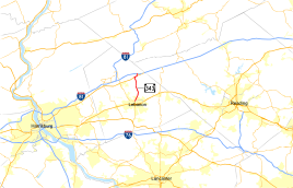
Route information Maintained by PennDOT Length: 8.21 mi[1] (13.21 km) Existed: 1928 – present Major junctions South end:  PA 72 in Lebanon
 US 22 in Fredericksburg
North end:  I-78 in Fredericksburg
Location Counties: Lebanon Highway system Roads in Pennsylvania
Interstate • US • State • Legislative←  PA 342
PA 344  →
→Pennsylvania Route 343 (designated by the Pennsylvania Department of Transportation as SR 0343) is an 8.21-mile (13.21 km) route between Lebanon, Pennsylvania and Fredericksburg, Pennsylvania. It begins at PA 72 and ends at Exit 6 of Interstate 78. State Route 343 heads mostly through urbanized areas, with several rural areas also surrounding. There is a concurrency with U.S. Route 22 near the northern terminus.
State Route 343 has had a number of different realignments, most of them relating to the northern terminus of the highway. The highway originally terminated at an intersection with SR 443 in Lickdale, moved to end in the community of Bordnersville soon after. The highway was then extended along the local continuation to end at U.S. Route 22 at an intersection in Harpers Tavern. In 1963, State Route 343 was moved back to Lickdale, and seven years after, moved to its northern terminus, thirteen years after the construction of Interstate 78.
Contents
Route description
State Route 343 begins at an intersection with State Route 72, near the Northwest Elementary School in Lebanon. State Route 343 heads eastward along Maple Street, a highly urbanized city street. The route intersects with North 8th Street and North 7th Street, where it turns northward from Maple Street. The highway also passed the Mount Lebanon Cemetery, but there is no direct access to it. At the intersection with Cherry Street, State Route 343 enters the community of Reindeldville, located northeast of downtown Lebanon. The stretch in Reindeldville is not long, with the highway entering Sunset at an intersection with Kimmerlings Road and Kochenderfer Road. At the intersection with Mount Lebanon Road in Eustontown, State Route 343 left the urbanized region and into a more rural region of east-central Pennsylvania.[1]
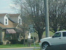 PA 343 beginning its way southward from US 22 in Fredericksburg
Still named North Seventh Street, State Route 343 heads northward, making a curve to the northwestern turn at Heffelfinger Road. At the intersection with Golf Road, the highway winds its way through the area of forests as South Pine Grove Street. The highway passes a nearby pond and the Freeport Mills Golf Course, just south of the community, Freeport Mills. A stream follows State Route 343 until the Pine Meadows Golf Course, where it turned eastward and crossed the highway. The highway begins to re-enter a more developed region, the town of Fredericksburg. Passing the "firemen's park", State Route 343 passes through Sharksville, a local community. Just north of Sharksville, the highway intersects with U.S. Route 22 (the William Penn Highway). The two highways become concurrent, and follow a trek to the northeast. South Pine Grove Road continues ahead of the intersection, without the state designation.[1]
State Routes 22 and 343 head to the northeast, passing to the south of Fredericksburg. The highways work as a bypass around the city, entering Bethel Township at an intersection with East Main Street, a major thoroughfare in Fredericksburg. At a nearby park, State Route 343 turns off U.S. Route 22 and heads to the northeast. The final intersection along 343 is with Sherwin Williams Drive near the Cedar Hill Cemetery. After that intersection, State Route 343 approaches the interchange with Interstate 78, intersecting with the eastbound off-ramp. After crossing over the interstate, State Route 343 terminates at an intersection with the westbound on-ramp. From there, the highway continues north as a locally-maintained road.[1]
History
State Route 343 was assigned in the mass numbering of state legislative routes in Pennsylvania during 1928. The highway then ran from the southern terminus in Lebanon, which was at the time, an intersection with U.S. Route 22. At Fredericksburg, the intersection with US 22 was then an intersection with State Route 43. There was no concurrency, and instead, the highway turned to the northeast and into Lickdale. There it terminated at an intersection with State Route 443.[2] The highway stayed intact for two years, until 1930, when the highway was extended a few miles to the community of Bordnersville, where it ended without another state highway. The highway then continued as a local highway.[3]
The highway was paved from Fredericksburg to an intersection with Lancaster Street and from Lickdale to Bordnersville in 1932.[4] In 1936, the Pennsylvania Department of Highways extended State Route 343 past Bordnersville and Lickdale, along the local road. This changed the northern terminus to an intersection with U.S. Route 22 (formerly the alignment of State Route 43) in Harper Tavern.[5] This alignment remained intact for more than two decades.[6] In 1963, even with the construction of Interstate 78 six years prior, State Route 343 was realigned once again by the Department of Highways. This time, Route 22 went from Harper Tavern back to Lickdale and the State Route 443 intersection.[7] The highway remained intact for another seven years, and in 1970, State Route 343 was realigned for the final time, this time using its current alignment. The northern terminus is now at an eastbound interchange with Interstate 78.[8][9]
Major intersections
The entire route is in Lebanon County.
Location Mile[1] Destinations Notes Lebanon 0.00 PA 72Fredericksburg US 22Begin/end concurrency Bethel Township US 22Begin/end concurrency 8.21 I-78Exit 6 (I-78) 1.000 mi = 1.609 km; 1.000 km = 0.621 mi See also
References
- ^ a b c d e Yahoo! Inc. Yahoo! Maps – overview map of PA 343 (Map). Cartography by NAVTEQ. http://maps.yahoo.com/#mvt=h&lat=40.454046&lon=-76.414298&zoom=18&q1=40.349913%2C-76.427355&q2=40.452728%2C-76.414824. Retrieved 2008-12-22.
- ^ Pennsylvania Department of Highways (1928). Map Showing Pennsylvania State Highways (Map).
- ^ Pennsylvania Department of Highways (1930). Tourist Map of Pennsylvania State Highways (Map).
- ^ Pennsylvania Department of Highways (1932). Tourist Map of Pennsylvania State Highways (Map).
- ^ Pennsylvania Scenic and Historical Commission (1936). Carefree Holidays Await You in Pennsylvania (Map).
- ^ Pennsylvania Department of Highways (1962). Pennsylvania Official Highway Map (Map).
- ^ Pennsylvania Department of Highways (1963). Pennsylvania Official Road Map (Map).
- ^ Pennsylvania Department of Transportation (1970). Pennsylvania (Map).
- ^ Pennsylvania Department of Transportation (2004). Pennsylvania (Map).
External links
- Jeff Kitsko's Pennsylvania Highways - PA 343
- Multiplex of PA 343 and US 22 on Tim Reichard's M-Plex.com
Roads in the Susquehanna Valley Beltway Interstate Highways U.S. Routes Limited-access Pennsylvania Routes Other Pennsylvania Routes PA 17 · PA 23 · PA 25 · PA 34 · PA 39 · PA 72 · PA 74 · PA 94 · PA 114 · PA 117 · PA 147 · PA 174 · PA 225 · PA 230 · PA 233 · PA 235 · PA 241 · PA 274 · PA 325 · PA 340 · PA 341 · PA 343 · PA 419 · PA 441 · PA 443 · PA 462 · PA 465 · PA 501 · PA 533 · PA 641 · PA 645 · PA 696 · PA 722 · PA 743 · PA 772 · PA 849 · PA 850 · PA 897 · PA 934 · PA 944 · PA 997 · PA 999Other Quadrant Routes Other notable roads Categories:- State highways in Pennsylvania
- Transportation in Lebanon County, Pennsylvania


Wikimedia Foundation. 2010.