- Pennsylvania Route 997
-
PA Route 997
Route information Maintained by PennDOT Length: 49 mi (79 km) Existed: 1928[1] – present Major junctions South end:  MD 64 south of Waynesboro
 PA 16 / PA 316 in Waynesboro
 PA 233 in Mont Alto
 US 30 in Greenwood

 I-81 / PA 696 near Chambersburg


 US 11/PA 997 Truck near Chambersburg
 PA 433 near Chambersburg
 PA 533 in Pleasant Hall
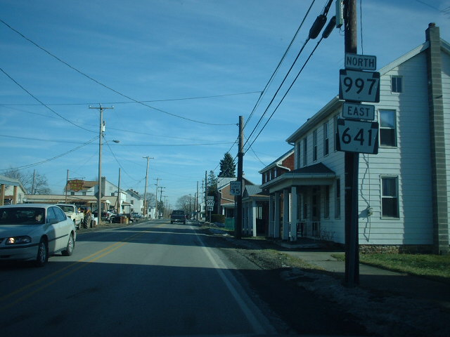
 PA 641 in Roxbury

 I-76/PA Tpk. near Roxbury
North end: PA 233 in McCreaLocation Counties: Franklin, Cumberland Highway system Roads in Pennsylvania
Interstate • US • State • Legislative←  PA 996
PA 998  →
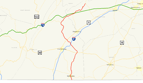
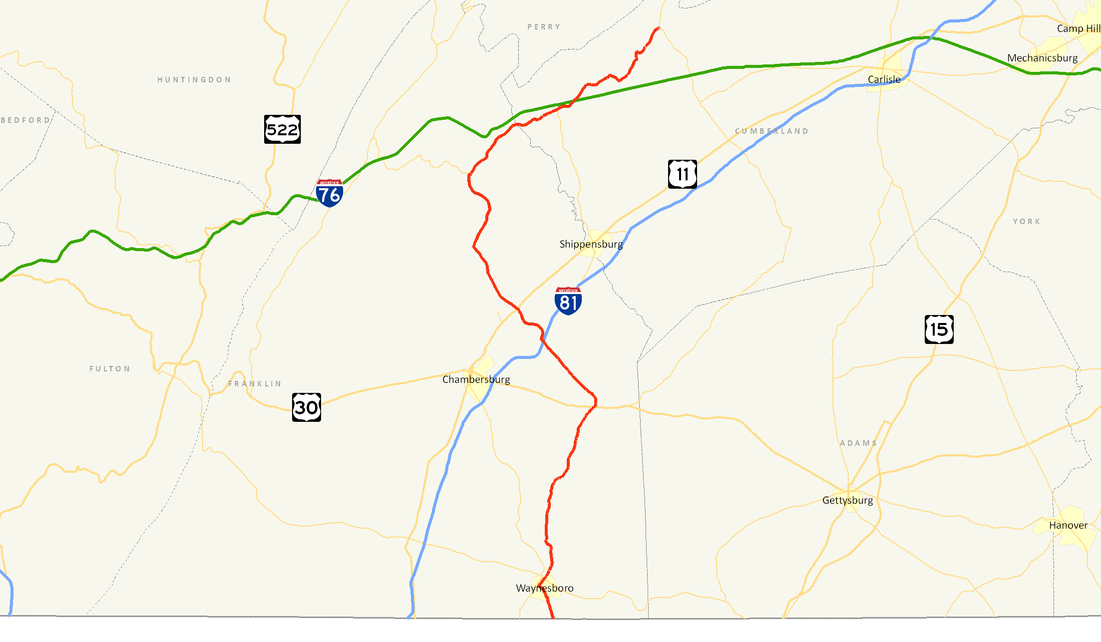
→Pennsylvania Route 997 is a 49-mile (79 km) route in Franklin and Cumberland Counties. The route begins at the Maryland state line south of Waynesboro and ends at Pennsylvania Route 233 in McCrea. The route was originally signed in 1928 from Waynesboro to Pennsylvania Route 433. Both termini, however, have been adjusted northward and southward. The route is concurrent with two state routes, 16 and 641, and one U.S. Route, Route 30. The route was assigned in 1928 up to U.S. Route 30 in Greenwood. The route was extended several times and has been on its current alignment since 1977.
Contents
Route description
Route 997 begins at the Maryland state line south of the town of Waynesboro.[2] The route heads northward, crossing East Branch and entering Waynesboro. There, Route 997 becomes concurrent with Pennsylvania Route 16. At the point where Route 997 turns to the north, Route 316 intersects with SR 997. Route 997 heads northward, leaving Waynesboro and Route 16 behind. The highway intersects with and enters Quincy. The highway leaves Quincy and continues northward towards Caledonia.[2]
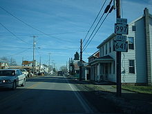 Concurrency of PA 997 and PA 641 in Roxbury
Route 997 parallels Route 316 and enters the town of Mont Alto, where it intersects with the western terminus of Pennsylvania Route 233.[2] After crossing through Mont Alto and nearby Pond Bank, Route 997 intersects with U.S. Route 30 in Fayetteville. The two routes are concurrent for a short distance in the town of Greenwood. Route 997 heads to the northwest and intersects with Pennsylvania Route 696, which parallels Interstate 81. Route 997 interchanges at Exit 20 of Interstate 81 soon after. The highway enters Scotland and leaves without intersecting with any state highways.[2]
Soon afterwards, U.S. Route 11 intersects in the Greene Township village of Greenvillage.[2] Route 997 continues to the northwest, intersecting with PA 533 and PA 641 (in Roxbury) before interchanging with Interstate 76 in Newburg at Exit 201. The route continues, now to the northeast, and passes Green Spring, a hunting region. Route 997 comes to an end at Pennsylvania Route 233 in McCrea, a route it previously intersected in Mont Alto.[2]
History
Route 997 was signed in 1928 from Waynesboro to US 30 in Fayetteville.[3] The southern terminus was changed to the state line in 1936 and the northern terminus was changed from Fayetteville to Greenvillage.[4] In 1941, Route 997 was shifted off the present PA 316 alignment to its current alignment.[5] Twenty-three years later, the northern terminus was shifted northward from Greenvillage to its current end in McCrea. In 1977, Route 997 was swapped off its alignment on Mont Alto Road, Main Street and Mount Pleasant Road onto its current route.[6]
Major intersections
County Location Mile[7] Destinations Notes Franklin Maryland state line 0.00 MD 64 (Smithsburg Pike)Southern terminus, continues as MD 64 Waynesboro 2.7 PA 16 east (Main Street)South end of PA 16 concurrency 2.8 PA 16 west (Main Street)North end of PA 16 concurrency Mont Alto 9.5 PA 233 (Park Street)Southern terminus of PA 233 Fayetteville 14.4 US 30 west (Lincoln Way)South end of US 30 concurrency 14.5 US 30 east (Lincoln Way)North end of US 30 concurrency Greene Township 19.6 PA 696 (Olde Scotland Way)Southern terminus of PA 696 19.7 I-81Exit 20 (I-81) 22.6 


US 11 / PA 997 Truck (Molly Pitcher Highway)Southern terminus of Culbertson Truck Route 23.9 
PA 433 / PA 997 Truck (Sunset Pike, Rowe Run Road)Northern terminus of Culbertson Truck Route Pleasant Hall 27.8 PA 533 (Orrstown Road)Western terminus of PA 533 Lurgan 27.8 PA 433 (Tanyard Hill Road)Northern terminus of PA 433 Roxbury 32.5 PA 641 west (Newburg Road)South end of PA 641 concurrency 32.7 PA 641 east (Newburg Road)North end of PA 641 concurrency Cumberland Newburg 36.7 I-76 / Penna. Tpk.Exit 201 (I-76) Blue Mountain, Via access road 38.2 PA 696Northern terminus of PA 696 Upper Mifflin Township 49.0 PA 233Northern terminus 1.000 mi = 1.609 km; 1.000 km = 0.621 mi Bannered routes

PA Route 997 Truck
Location: Franklin County, Pennsylvania Pennsylvania Route 997 Truck is a 3-mile large vehicles route in rural Franklin County, Pennsylvania. It was signed in 1980 along U.S. Route 11 and Pennsylvania Route 433. The route ends at 433 and 997 in Letterkenney Township.
See also
Former alignments
References
- ^ Jeff Kitsko (2008). "Pennsylvania Highways - Pennsylvania Route 997". PA Highways. http://www.pahighways.com/state/PA950-999.html#PA997. Retrieved 2008-10-08.
- ^ a b c d e f Pennsylvania Department of Transportation (2006). Pennsylvania - Official State Map (Map).
- ^ Pennsylvania Department of Highways (1928). Map Showing Pennsylvania State Highways (Map).
- ^ Pennsylvania Scenic and Historic Commission (1936). Carefree Holidays About You in Pennsylvania (Map).
- ^ Pennsylvania Department of Highways (1940). Official Road Map of Pennsylvania (Map). ftp://ftp.dot.state.pa.us/public/pdf/BPR_pdf_files/Maps/Statewide/Historic_OTMs/1940fr.pdf. Retrieved 2008-02-20.
- ^ Pennsylvania Department of Transportation (1977). Pennsylvania: Official Transportation Map (Map).
- ^ Google, Inc. Google Maps – overview map of PA 997 (Map). Cartography by Google, Inc. http://maps.google.com/maps?hl=en&rlz=1T4ADBF_enUS232US232&q=from:+PA-997+%4039.720403,+-77.567429+to:+Walnut+St+%4039.754462,+-77.575687+to:Lincoln+Hwy/Lincoln+Way+E+%4039.906080,+-77.518600+to:Enola+Rd/PA-997+%4040.157697,+-77.584405+to:PA-997/Roxbury+Rd+%4040.238950,+-77.444030&um=1&ie=UTF-8&sa=N&tab=wl. Retrieved 2008-02-20.
Roads in the Susquehanna Valley Beltway Interstate Highways U.S. Routes Limited-access Pennsylvania Routes Other Pennsylvania Routes PA 17 · PA 23 · PA 25 · PA 34 · PA 39 · PA 72 · PA 74 · PA 94 · PA 114 · PA 117 · PA 147 · PA 174 · PA 225 · PA 230 · PA 233 · PA 235 · PA 241 · PA 274 · PA 325 · PA 340 · PA 341 · PA 343 · PA 419 · PA 441 · PA 443 · PA 462 · PA 465 · PA 501 · PA 533 · PA 641 · PA 645 · PA 696 · PA 722 · PA 743 · PA 772 · PA 849 · PA 850 · PA 897 · PA 934 · PA 944 · PA 997 · PA 999Other Quadrant Routes SR 3015 · SR 3020Other notable roads Categories:- State highways in Pennsylvania

Wikimedia Foundation. 2010.