- Collingdale, Pennsylvania
-
Borough of Collingdale Borough Country United States State Pennsylvania County Delaware Elevation 95 ft (29 m) Coordinates 39°54′50″N 75°16′43″W / 39.91389°N 75.27861°W Area 0.9 sq mi (2.3 km2) - land 0.9 sq mi (2 km2) - water 0.0 sq mi (0 km2), 0% Population 8,664 (2000) Density 9,995.9 / sq mi (3,859.4 / km2) Timezone EST (UTC-5) - summer (DST) EDT (UTC-4) ZIP Code 19023 Area code 610 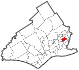 Location of Collingdale in Delaware County
 Location of Collingdale in Pennsylvania
 Location of Pennsylvania in the United States
Collingdale is a borough in Delaware County, Pennsylvania, United States. The population was 8,664, at the 2000 census, 502 above the 1940 count of 8,162.
Contents
Geography
Collingdale is located at 39°54′50″N 75°16′43″W / 39.91389°N 75.27861°W (39.913889, -75.278647)[1].
According to the United States Census Bureau, the borough has a total area of 0.9 square miles (2.3 km2), all of it land.
Demographics
Historical populations Census Pop. %± 1930 7,857 — 1940 8,162 3.9% 1950 8,443 3.4% 1960 10,268 21.6% 1970 10,605 3.3% 1980 9,539 −10.1% 1990 9,175 −3.8% 2000 8,664 −5.6% www.dvrpc.org/data/databull/rdb/db82/appedixa.xls As of the census[2] of 2000, there were 8,664 people, 3,188 households, and 2,183 families residing in the borough. The population density was 9,995.9 people per square mile (3,845.0/km²). There were 3,404 housing units at an average density of 3,927.3 per square mile (1,510.7/km²). The racial makeup of the borough was 49.36% White, 51.274% African American, 0.29% Native American, 1.62% Asian, 0.01% Pacific Islander, 0.24% from other races, and 1.20% from two or more races. Hispanic or Latino of any race were 0.89% of the population.
There were 3,188 households out of which 33.9% had children under the age of 18 living with them, 46.0% were married couples living together, 16.5% had a female householder with no husband present, and 31.5% were non-families. 26.8% of all households were made up of individuals and 10.8% had someone living alone who was 65 years of age or older. The average household size was 2.71 and the average family size was 3.32.
In the borough the population was spread out with 28.6% under the age of 18, 8.3% from 18 to 24, 31.1% from 25 to 44, 19.0% from 45 to 64, and 13.0% who were 65 years of age or older. The median age was 34 years. For every 100 females there were 94.3 males. For every 100 females age 18 and over, there were 90.4 males.
The median income for a household in the borough was $40,207, and the median income for a family was $47,288. Males had a median income of $38,015 versus $27,955 for females. The per capita income for the borough was $16,751. About 6.9% of families and 8.4% of the population were below the poverty line, including 11.7% of those under age 18 and 3.3% of those age 65 or over.
AS OF 2000, The racial makeup of the borough was 81.70% White (U.S. Census), 24.94% African American (U.S. Census), 0.29% Native American (U.S. Census), 1.62% Asian (U.S. Census), 0.01% Pacific Islander (U.S. Census), 0.24% from Race (United States Census), and 1.20% from two or more races. Hispanic (U.S. Census) or Latino (U.S. Census) of any race were 0.89% of the population.
About
Frank Kelly is serving his eleventh consecutive four-year term as Mayor of Collingdale. He has served over 41 consecutive years as Mayor of Collingdale. This is the longest consecutive Mayoral term in the history of Pennsylvania.
Southern rock group 38 Special used the Collingdale Police force in making the video for their song "Back Where You Belong". In the video the Collingdale Chief of Police Robert Morris began the video with an homage to the TV show "Hill Street Blues". After giving a short speech, he told the officers: "Let's be careful out there".[citation needed]. Part of the video was filmed in neighboring Philadelphia, PA under the Walt Whitman Bridge.
Landmarks
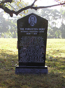 Octavius Catto's grave in Eden Cemetery
Almost half of Collingdale's area is made up of four cemeteries, three of which are active. Eden Cemetery is an African-American cemetery, where many notable persons are buried, including Marian Anderson. Har Zion Cemetery and Mt. Lebanon Cemetery are Jewish cemeteries. The fourth, an American Civil War-era cemetery, has been maintained by a local Veterans of Foreign Wars Post.
Felton Ave. is named after W. C. Fields's maternal grandfather, a native of the town when it was part of Darby Township.
Over the years the Collingdale Athletic Club has sponsored many championship teams.
References
- ^ "US Gazetteer files: 2010, 2000, and 1990". United States Census Bureau. 2011-02-12. http://www.census.gov/geo/www/gazetteer/gazette.html. Retrieved 2011-04-23.
- ^ "American FactFinder". United States Census Bureau. http://factfinder.census.gov. Retrieved 2008-01-31.
Categories:- Populated places established in 1891
- Populated places in Pennsylvania with African American majority populations
- Boroughs in Delaware County, Pennsylvania


Wikimedia Foundation. 2010.