- New Jersey Route 324
-
Route 324
Old Ferry Road 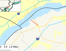
Map of Route 324, which is highlighted in red.Route information Maintained by the New Jersey Department of Transportation Length: 1.51 mi[1] (2.43 km) Existed: 1974 – present Major junctions West end: Shore of the Delaware River in Logan Township East end: Cul-de-sac in Logan Township Highway system New Jersey State Highway Routes
Interstate and US←  US 322
Route 347  →
→Route 324 is an isolated state highway in Logan Township in the U.S. state of New Jersey. The two-lane concrete route runs along the 1.51-mile (2.43 km) long alignment of Old Ferry Road from the shore of the Delaware River to a cul-de-sac near the interchange between U.S. Route 322 and U.S. Route 130 in Logan Township. The route does not intersect with any state routes or county routes along its entire alignment.
Route 324 was a former alignment of U.S. Route 322 that served the Bridgeport-Chester ferry between Bridgeport, New Jersey and Chester, Pennsylvania. The ferry first ran on July 1, 1930, with Route 322 being designated along the ferry and its access road in 1936 from Pennsylvania. The highway and ferry also shared the co-designation of State Highway Route S-44, a spur off State Highway Route 44 in Bridgeport. Route S-44 was decommissioned in the state highway renumbering while Route 322 remained intact until the opening of the Commodore Barry Bridge in February 1974. The ferry made its last run at 8 PM on February 1, and closed down for good. Route 322 was realigned onto the Commodore Barry Bridge while the former ferry alignment became Route 324.
Contents
Route description
Route 324 begins at the shoreline of the Delaware River and the wreckage of the old ferry dock in Logan Township. The route heads eastward along Old Ferry Road, a two-lane concrete roadway surrounded by trees and rotting fields. The highway continues eastward, running through the dying trees and rotting fields until the trees begin growing in population. The two-lane concrete highway remains such for a distance, paralleling U.S. Route 322 to the south. The route heads to the east, crossing south of a pond and intersecting with Springer Lane and a dirt road in Logan Township.[2]
At Springer Lane, which is a former alignment of New Jersey Route 44, the route becomes open, crossing under power lines and intersecting with former alignments of roadway, overgrown with grass. A short distance from Springers Lane, the highway continues to the only other intersection along the highway, which is for Island Road, a connector to U.S. Route 130. The highway, however, continues through the desolate portions of Logan Township along a power line. A short distance later, the route passes to the south of the only businesses along the highway, a boat marina and two residential homes. Route 324 continues as a two-lane concrete road eastward until reaching a cul-de-sac just short of the U.S. Route 130/U.S. Route 322 interchange in Logan Township, where the designation ends.[2]
History
 Route 322 between the ferry and US 130/SHR 44 was State Highway Route S-44 until 1953
The ferry route that Route 324 serviced first made its crossings of the Delaware River on July 1, 1930 from Chester, Pennsylvania to Bridgeport, New Jersey. The ferry service was run with two boats, Chester, a large boat with a capacity of 60 motor vehicles, and Bridgeport, a smaller boat with a capacity of 48. The ferry system was seen as an advantage across the Delaware, providing drivers a backup from the few bridges that existed along the river.[3] In 1936, the Bridgeport-Chester Ferry was granted the alignment for the extension of U.S. Route 322 from Pennsylvania and into New Jersey.[4][5] Along with the U.S. Route 322 designation, the New Jersey State Highway Department designated the alignment of Route 322 from the ferry to U.S. Route 130, then designated as State Highway Route 44, as State Highway Route S-44.[6]
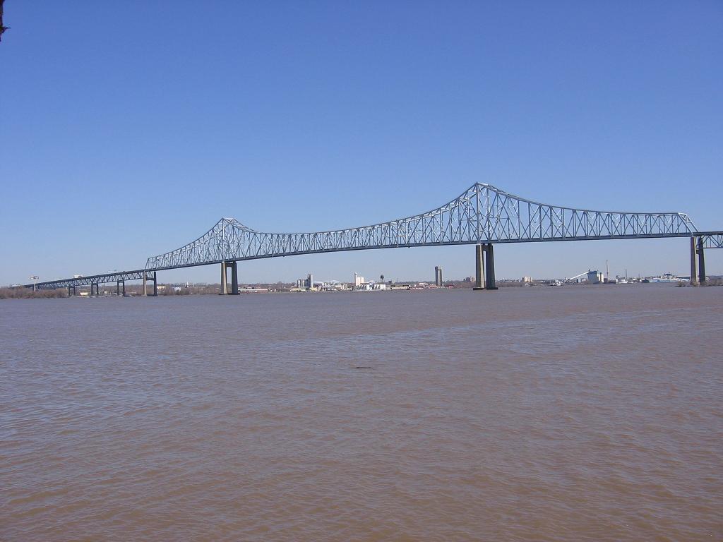
 Commodore Barry Bridge viewed from NJ 324See also: Commodore Barry Bridge
Route 322 survived the state highway renumbering because of the fact it was a U.S. Route. However, the co-designation on the ferry stretch, State Highway Route S-44 was decommissioned in favor of just one designation.[7][8] Route 322 remained on the ferry route for several years, and plans arose during the 1960s to construct a new bridge between the Delaware Memorial Bridge and Walt Whitman Bridge.[9] Construction began that year, and on February 1, 1974, the newly renamed Commodore Barry Bridge opened for traffic. At 8 PM that evening, the Bridgeport-Chester Ferry ran its final 1-mile (1.6 km) boat ride across the Delaware, and the service was closed down for good.[10] The alignment of Route 322 was moved onto the Commodore Barry Bridge,[11] while the former alignment became designated as Route 324. The route has remained virtually intact since then.[1]
Major intersections
The entire route is in Logan Township, Gloucester County.
Mile[1] Destinations Notes 0.00 Delaware River Western terminus of NJ 324. 0.95 Springers Lane 1.11 Island Road 1.51 Cul-de-sac Eastern terminus of NJ 324. 1.000 mi = 1.609 km; 1.000 km = 0.621 mi See also
 U.S. Roads portal
 New Jersey portal
References
- ^ a b c "Route 324 straight line diagram". New Jersey Department of Transportation. 2009. http://www.state.nj.us/transportation/refdata/sldiag/00000324__-.pdf. Retrieved October 17, 2009.
- ^ a b Bing Maps/Microsoft Inc. (2009). Overview map of New Jersey Route 324 (Map). Cartography by NAVTEQ Inc.. http://www.maps.bing.com/maps/default.aspx?v=2&FORM=LMLTCP&cp=qn2s7b8qk2qz&style=b&lvl=1&tilt=-90&dir=0&alt=-1000&phx=0&phy=0&phscl=1&scene=39921883&rtp=pos.39.8047998547554_-75.3509491682053_near%20Old%20Ferry%20Rd%2C%20Bridgeport%2C%20New%20Jersey%2008014%2C%20United%20States__~pos.39.8182994127274_-75.3727501630783_near%20Old%20Ferry%20Rd%2C%20Bridgeport%2C%20New%20Jersey%2008014%2C%20United%20States__&rtop=0~0~0&encType=1. Retrieved October 17, 2009.
- ^ "Chester-Bridgeport Ferry". Chester, Pennsylvania. 2009. http://www.oldchesterpa.com/chester_bridgeport_ferry.htm. Retrieved October 17, 2009.
- ^ "US 322 Straight Line Diagram". Internet Archives WayBack Machine. New Jersey Department of Transportation. 2004. Archived from the original on 2004-07-24. http://web.archive.org/web/20040724135549/http://www.state.nj.us/transportation/refdata/sldiag/00000322__-.pdf. Retrieved 2007-06-14.
- ^ Mid-West Map Co. (1941). Map of Pennsylvania and New Jersey (Map). Cartography by H.M. Gousha. http://www.mapsofpa.com/roadcart/1941_1467m.jpg. Retrieved 2009-03-29.
- ^ State of New Jersey, Laws of 1939, compiled.
- ^ 1953 renumbering, New Jersey Department of Highways, http://en.wikisource.org/wiki/1953_New_Jersey_state_highway_renumbering, retrieved July 31, 2009
- ^ "New Road Signs Ready in New Jersey". The New York Times. December 16, 1952. http://img123.imageshack.us/img123/6933/19521216newroadsignsreaiu6.jpg. Retrieved 2009-07-20.
- ^ Reilly, Robert A. (May 24, 1970). "Bridge Promises Brighter Life for Poor of Chester". The Philadelphia Inquirer.
- ^ "Bridgeport-Chester Bridge Opens, Replacing Ferry". The New York Times. February 2, 1974.
- ^ Chevron Oil Company (1969). Map of New Jersey (Map). Cartography by H.M. Gousha.
External links
Categories:- State highways in New Jersey
- Transportation in Gloucester County, New Jersey


Wikimedia Foundation. 2010.