- New Jersey Route 75
-
Route 75
Route information Maintained by NJDOT Existed: 1961 – 1997 (Never built) Major junctions West end:  US 1/9 in Newark
 US 22 in Newark
 I-78 in Newark
East end:  I-280 in Newark
(formerly Route 21 in Newark)
Location Counties: Essex Highway system New Jersey State Highway Routes
Interstate and US←  Route 74
I-76  →
→Route 75 was a proposed freeway in the U.S. State of New Jersey in the Newark area in 1960s and 1970s. It was designed to connect the existing Route 21 freeway north of Newark with Interstate 78, U.S. Route 1/9, and Newark Airport. The state of New Jersey applied for interstate status for the route in 1970, but construction of the road remained stalled in courts throughout the 1970s. In 1973, the state of New Jersey and the Federal Highway Administration shelved plans for the route, and in 1997, the state of New Jersey officially removed the route from its route logs. Despite its removal, vestiges of Route 75 still remain. The first example is Exit 13 on Interstate 280 eastbound in Newark. The exit is an enormous three lane ramp, while through traffic on I-280 has only two lanes. The ramp comes to a stop at a traffic light on First Street just south of Orange Street.[1] Also, at Exit 56 off Interstate 78, large flyover ramps meant for a freeway diverge from the roadway, but terminate at city streets.[2]
Contents
Proposed route
The Route 75 Freeway was intended to begin at an interchange with U.S. Route 1 and U.S. Route 9 south of Newark Liberty International Airport. The route was to head to the northwest, crossing an interchange with New Jersey Route 27 (Frelinghuysen Avenue) on the southbound side. The highway would continue, crossing a southbound trumpet interchange with U.S. Route 22, before entering the massive trumpet interchange with Interstate 78. From Interstate 78, Route 75 would head northward directly, interchanging with several local streets in Newark including Runyon, Avon, Kinney and Market on the southbound side and Alpine, Waverly, Court Streets along with Central Avenue (County Route 508) on the northbound side. From Central Avenue, the new freeway would enter the large interchange with Interstate 280 and New Jersey Route 58 and follow current-day Irvine Turner Boulevard into University Heights. From Interstate 280, Route 75 was to interchange with Park Avenue heading northbound before making a bend to the northeast, where it would merge in with Route 21 (the McCarter Highway) just south of Chester Avenue (Exit 4).[3]
History
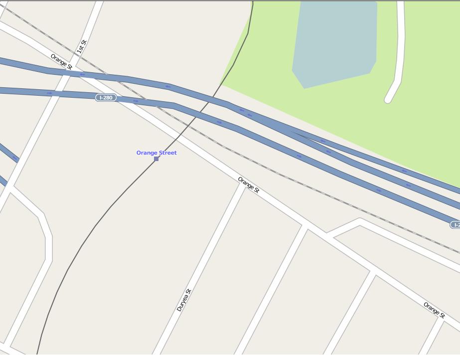
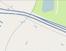 Map of Orange Street and Hecker Street in Newark. Interstate 280 is the dual highway to the north, and although unmarked, this is where after a suppressed proposal, where NJ 75 was to end
In 1961, the New Jersey State Highway Department announced plans to lower the existing traffic congestion through Newark with a new freeway through the center of the city. A study was almost immediately funded, named the "Newark Transportation Study", which suggested the construction of a new north–south arterial through midtown Newark. This new freeway was to connect U.S. Route 1, U.S. Route 9, Interstate 280 (co-signed New Jersey Route 58), Interstate 78 and Newark Liberty International Airport for Newark through traffic. The nearby New Jersey Route 21 (McCarter Highway) arterial was designated to handle local traffic in this situation. The new freeway was designed to handle 45,000 people in annual daily traffic by 1975. The new freeway, designated as Route 75, was to begin at an interchange with U.S. Routes 1 and 9 in the southern end of Newark (near the Airport) and continue through Midtown Newark to an interchange with Route 21 south of current-day Exit 4 (Chester Avenue), where the right-of-ways would merge in.[3]
In 1962, the State Highway Department brought up the theory of expanding the Route 75 Freeway into a larger, 60 miles (97 km) Interstate 95 alignment extension of the Somerset Freeway. The route was to serve as the local area with an express-local format. Under this, the express lanes would serve Interstate 95 while the local lanes would serve Route 75.[4] However, the plan did not gain traction and the Federal Bureau of Public Roads denied Interstate 95's alignment north of Interstate 287 in Middlesex County.[5] (The Somerset Freeway portion Interstate 95 was canceled in 1982.) To add insult to injury, the State Highway Department had to scale back plans for the Route 75 Freeway in 1967. They recommended constructing the portion between Interstate 78 and Interstate 280 first, later to become a vital artery for Essex and Passaic Counties. In 1967, the freeway was scaled back to two miles and would cost $69.7 million (1967 USD),[6] and just two years later, this had ballooned to $115 million. Of this $115 million, a significant portion would go to condemning buildings and acquiring right-of-way. As a result, the Tri-State Transportation Commission suggested to construct only the Interstate 78-280 portion and not the extensions to Interstate 80 and the Goethals Bridge.[7]
After high costs began to inhibit further progress, the Department of Transportation suspended construction of the Route 75 Freeway in 1969. Although construction was stopped, the state forwarded the proposal of getting Route 75 to become an Interstate in 1970.[8] The expressway remained on maps through the early 1970s until the state and federal government both shelved the freeway. In 1997, the New Jersey State Legislature appealed Route 75 from state law.[9] Beginning in 2005, the state started construction on the University Heights Connector along the Route 75 right-of-way. As a result, the new connector used the old ramps built for Route 75 into Irvine Turner Boulevard in Newark. The project completed in 2008.[10]
Proposed exit list
The following list shows the interchanges that were to be built on NJ 75 prior to the scaling back of the project.
The entire route was in Newark, Essex County.
Mile Destinations Notes 0.0 US 1/9Proposed southern terminus of Route 75  Route 27 (Frelinghusyen Avenue)
Southbound exit only US 22Southbound exit only I-78 Route 27 (Frelinghusyen Avenue)Southbound exit only Runyon Street Southbound exit only Alpine Street Northbound exit only Avon Avenue Southbound exit only Waverly Avenue Northbound exit only Kinney Street Southbound exit only Court Street Northbound exit only Market Street Southbound exit only  CR 508 (Central Avenue)
Northbound exit only I-280After truncation, Route 75 was to have its northern terminus here Park Avenue Northbound exit only Route 21Proposed northern terminus of Route 75 1.000 mi = 1.609 km; 1.000 km = 0.621 mi See also
 U.S. Roads portal
 New Jersey portal
References
- ^ Google, Inc. Google Maps – Traffic light at First Street, just south of Orange Street (Map). Cartography by Google, Inc. http://maps.google.com/maps?f=q&hl=en&q=Newark,+NJ&ie=UTF8&z=17&ll=40.751735,-74.187702&spn=0.003926,0.013561&t=h&om=1&iwloc=addr. Retrieved 2007-09-28.
- ^ Google, Inc. Google Maps – Interstate 78 - Exit 56 (Map). Cartography by Google, Inc. http://maps.google.com/maps?f=q&hl=en&q=Newark,+NJ&ie=UTF8&om=1&z=16&ll=40.711646,-74.197197&spn=0.007856,0.027122&t=h. Retrieved 2007-09-28.
- ^ a b Newark Transportation Study. New Jersey State Highway Department. 1961.
- ^ Alternate Route Study: Interstate Route 95. New Jersey State Highway Department. 1962.
- ^ Transportation 1985: A Regional Plan. Tri-State Transportation Commission. 1966.
- ^ New Jersey Highway Facts. New Jersey Department of Transportation. 1967.
- ^ New Jersey Highway Facts. New Jersey Department of Transportation. 1969.
- ^ Report on the Status of the Federal-Aid Highway Program. Committee on Public Works, U.S. Senate. 1970.
- ^ ROUTE NO. 75. L.1967, c. 87, s. 1, repealed 1997, c.143, s.3.
- ^ "University Heights Connector". Ewing, New Jersey: New Jersey Department of Transportation. 2008. http://www.state.nj.us/transportation/commuter/roads/universityhts/. Retrieved 18 December 2009.
External links
Unbuilt Highways in New Jersey Interstate Highways I-695 • I-895State highways Toll roads and other highways Categories:- State highways in New Jersey
- Transportation in Essex County, New Jersey

Wikimedia Foundation. 2010.