- Eisenhower Parkway
-
County Route 609
Eisenhower Parkway Route information Maintained by Essex County Length: 4.12 mi[1] (6.63 km) Major junctions South end:  CR 510 in Livingston
 Route 10 in Livingston
North end:  I-280 in Roseland
Highway system County routes in New Jersey
500-series • County routes in Essex County←  CR 608
CR 610  →
→Eisenhower Parkway, also known as County Route 609, is a highway in Essex County, New Jersey, located in the municipalities of Roseland and Livingston. Eisenhower Parkway dead ends at South Orange Avenue (County Route 510) in Livingston near the Livingston Mall and just north of Interstate 280 in Roseland.
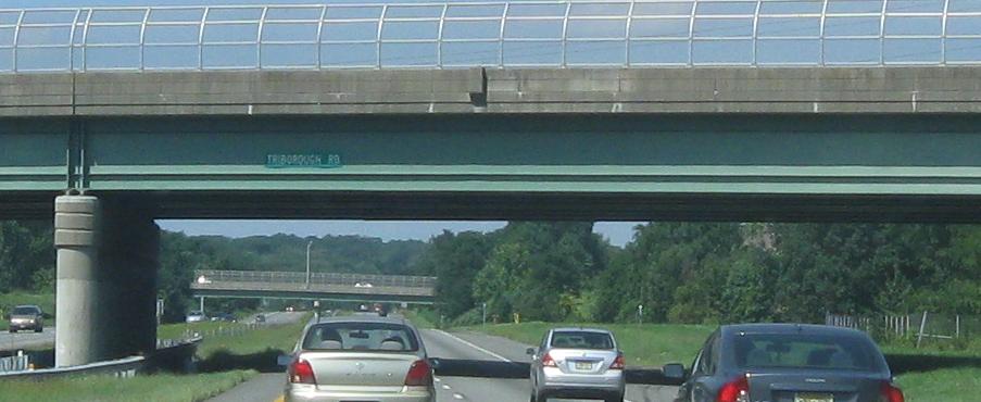
The original plan of the Parkway was to extend to Passaic Avenue in West Caldwell on the northern end and to Route 24 in Chatham on the southern end. There is a complete cloverleaf interchange at Route 24, which would have been Interchange 5 on 24 (and there were once blank signs erected on 24 West). The bridges over Route 24, which would have been part of Eisenhower Parkway, are currently open to all-terrain vehicles.[2] Had it been extended to the south, it was going to be called Triborough Road (at least in Chatham and Florham Park).[3] Signage on the interchange bridge bears the name "Triborough Road".
Contents
Route description
The Eisenhower Parkway begins at an intersection with CR 510 in Livingston, Essex County, heading north as a four-lane divided highway. The road passes the Livingston Mall before becoming undivided and passing to the east of the Commonwealth Water Company Reservoir Number Three. Upon turning northeast, the roadway becomes divided again as it crosses CR 607 and passes through forests. The Eisenhower Parkway intersects Route 10 at the modified Livingston Circle, at which point the road passes businesses as CR 661 branches to the east of the road. The highway heads north-northeast through more forested areas with occasional commercial development, meeting CR 661 again prior to crossing into Roseland. Here, the road crosses the Morristown and Erie Railway and passes businesses, crossing CR 611 prior to coming to a cloverleaf interchange with I-280. At this interchange, the CR 609 designation ends and the Eisenhower Parkway continues northeast to a dead end a short distance later.[1][4]
Major intersections
The entire route is in Essex County.
Location Mile[1] Destinations Notes Livingston 0.00 CR 510 (South Orange Avenue)Southern terminus 0.96  CR 607 (Walnut Street)
1.71-1.76 Route 10 (Mount Pleasant Avenue)Livingston Circle 1.96  CR 661 north (Beaufort Avenue)
3.18 CR 661 south (Beaufort Avenue)Roseland 3.73  CR 611 (Eagle Rock Avenue)
4.12 I-280Northern terminus of CR 609, Eisenhower Parkway continues to dead end 1.000 mi = 1.609 km; 1.000 km = 0.621 mi See also
 U.S. Roads portal
 New Jersey portal
References
- ^ a b c County Route 609 straight line diagram from New Jersey Department of Transportation
- ^ Abandoned NJ 24 interchange
- ^ Triborough Road overpass
- ^ Google, Inc. Google Maps – overview of Eisenhower Parkway (Map). Cartography by Google, Inc. http://maps.google.com/maps?f=d&source=s_d&saddr=S+Orange+Ave+%26+Eisenhower+Pkwy,+Livingston,+Essex,+New+Jersey+07039&daddr=eisenhower+parkway+and+interstate+280&hl=en&geocode=FWctbgIdumWR-ymlOjrIKanDiTFzPAiaPN1WvA%3BFVTsbgIdvPKR-ym9hJrl8qnDiTEG9opVfPegtQ&mra=pd&mrcr=0&sll=40.775015,-74.357318&sspn=0.00741,0.021136&ie=UTF8&t=h&z=13. Retrieved January 8, 2011.
Unbuilt Highways in New Jersey Interstate Highways I-695 • I-895State highways Toll roads and other highways Categories:- Transportation in Essex County, New Jersey

Wikimedia Foundation. 2010.