- Hackensack River
Geobox River
name = Hackensack River
native_name =
other_name =
other_name1 =
image_size =
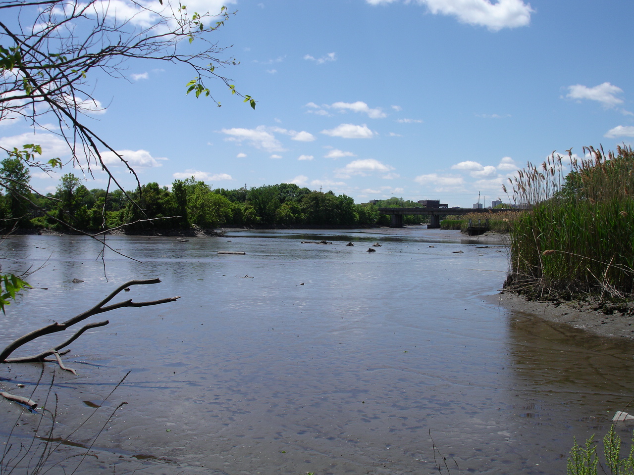
image_caption = A view of the Hackensack River taken from the shore in Teaneck
country =USA
country1 =
state =New Jersey
state1 =New York
region_type = Counties
region = Hudson, NJ
region1 = Bergen, NJ
region2 = Rockland, NY
district =
district1 =
city = Hackensack, NJ
city1 =
length_imperial = 54
watershed_imperial =
discharge_location = New Milford, NJ
discharge_average_imperial = 173
discharge_max_imperial = 880
discharge_min_imperial = 0
discharge1_location = West Nyack, NY
discharge1_average_imperial = 58
source_name =
source_location = West Haverstraw
source_district =
source_region = Rockland County
source_state = New York
source_country = USA
source_lat_d = 41
source_lat_m = 11
source_lat_s = 00
source_lat_NS = N
source_long_d = 73
source_long_m = 59
source_long_s = 24
source_long_EW = W
source_elevation_imperial = 120
source_length_imperial =
mouth_name =Newark Bay
mouth_location =
mouth_district =
mouth_region = Hudson County
mouth_state = New Jersey
mouth_country = USA
mouth_lat_d = 40
mouth_lat_m = 42
mouth_lat_s = 55
mouth_lat_NS = N
mouth_long_d = 74
mouth_long_m = 06
mouth_long_s = 42
mouth_long_EW = W
mouth_elevation_imperial = 0
tributary_left =
tributary_left1 =
tributary_right =
tributary_right1 =
free_name =
free_value =
map_size = 300
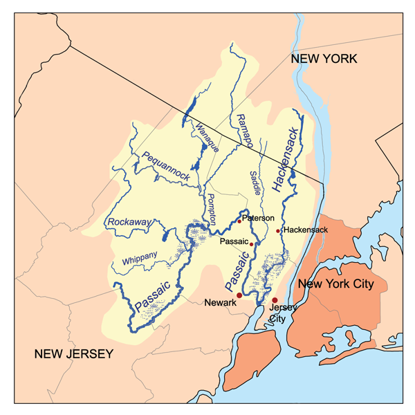
map_caption = The Passaic and Hackensack watersheds The Hackensack River is a river, approximately 45 mi (72 km) long, in theU.S. state s ofNew York andNew Jersey , emptying intoNewark Bay , a back chamber ofNew York Harbor . The watershed of the river includes part of the suburban area outsideNew York City just west of the lowerHudson River , which it roughly parallels, separated from it by theNew Jersey Palisades . It also flows through and drains theNew Jersey Meadowlands . The lower river, which is navigable as far as the city of Hackensack, is heavily industrialized and forms a commercial extension of Newark Bay. Once believed to be the among the most polluted water courses in the United States, it is has staged a modest revival in recent decades. The river is sometimes affectionately nicknamed the "Hacky" for short.Description
The Hackensack River rises in southeastern New York, in Rockland County, just west of the
Hudson River and approximately 1 mi (1.6 km) south of West Haverstraw. It flows briefly southeast, into theDeForest Lake reservoir, separated form the Hudson by less than 3 mi (5 km). South of the dam, it then flows south, diverging from the Hudson. Just across the New Jersey state line, in northern Bergen County, it is impounded to form the reservoirLake Tappan .South of Lake Tappan, it flows in a
meander ing course southward through the suburban communities of New Jersey. Near Oradell, it is impounded to formOradell Reservoir , where it is joined by several streams, including theDwars Kill andPascack Brook .Van Buskirk Island , a man-made island and site of theNew Milford Plant of the Hackensack Water Company , lies in this area. South of the reservoir, it flows past River Edge, Hackensack, Teaneck, and Ridgefield Park, once again approaching within 3 mi (5 km) of the Hudson, and separated from it by the ridge of the Palisades.At Little Ferry, it is joined by the broad
Overpeck Creek , then flows southward, widening in a broad meandering tidalestuary through the Meadowlands, forming extensive side streams andwetland s. South of North Bergen, it forms the boundary between Bergen County to the west and Hudson County to the east. Opposite Secaucus it is joined byBerrys Creek , then flows past the western edge of Jersey City, which overlooks the river's valley from the ridge of the Palisades, before forming Newark Bay at its confluence with thePassaic River between Jersey City and Kearny.As it flows through the Meadowlands it is traversed by numerous rail and road bridges.
History
The name of the river comes from the Lenape word "Ackingsack", meaning "flat confluence of streams". Conflicts with the Lenape prevented the early Dutch settlers of the
New Netherland colony from expanding westward into the valley into late in the 17th century. The river furnished both the Native Americans and theEurope an settlers with abundant runs ofherring ,shad andstriped bass .In the colonial era, the river and the surrounding Meadowlands presented a formidable difficulty in transportation and communication. The wetlands helped allow the escape of the
Continental Army underGeorge Washington in 1776 after several defeats at the hands of the British army on the east side of the Hudson. It later served as a protective barrier that allowed Washington's army to encamp in the nearby hills near Morristown.In the last two centuries, the river has suffered from extremely severe
pollution . The construction of theOradell Reservoir dam in 1921 essentially changed the lower river from a free-flowing stream into a brackish estuary, allowing the encroachment of marine species. By the 1960s, however, much of the lower river was essentially a turbidoxygen -less dead zone, with only the hardiest of species such as themummichog able to survive in its waters.Berrys Creek was once thought to be the most polluted stream in the United States.The river has recovered somewhat in recent decades following the decline in manufacturing in the area, as well as from enforcement of such regulations as the
Clean Water Act and from the efforts of local conservancy groups. Recreational fishing has staged a modest comeback, despite continuing health advisories against the consumption of catch.The future of the
wetland s around the lower river has been an ongoing controversy between development and preservation groups in recent decades. The controversial "Hackensack Meadowlands Development Commission" (now theNew Jersey Meadowlands Commission ) was formed by the state in 1968 to manage development and habitat preservation.Tributaries
*
Berrys Creek
*Overpeck Creek
*Pascack Brook ee also
*
List of New Jersey rivers
*List of New York rivers
*List of crossings of the Hackensack River
*Little Ferry Seaplane Base
*Hackensack RiverWalk External links
* [http://geocities.com/hrckc/links/hackensack/map.htm Map of the Hackensack River watershed]
* [http://www.hackensackriverkeeper.org/ Hackensack Riverkeeper] an environmental organization
* [http://www.fdu.edu/visitorcenter/thtides.html Farleigh Dickinson University: Hackensack River tides]
* [http://www.eorthe.com/02a_e_hack/00_hack_home.htm Hackensack River bridges]
* [http://www.wildnj.com/gest2.htm Wild New Jersey: Fishes of the Hackensack River]
* [http://www.bergenswan.org/ Bergen SWAN]
* [http://www.teaneckgreenway.org/ Friends of the Hackensack River Greenway through Teaneck]
* [http://www.meadowlands.state.nj.us/ New Jersey Meadowlands Commission]
* [http://www.meadowlands.state.nj.us/ec/ Meadowlands Environment Center]
* [http://meri.njmeadowlands.gov/ Meadowlands Environmental Research Institute (MERI)]
* [http://www.wma5nj.org/ Watershed Management Area 5 (WMA 5)] , contains the Hackensack River, Hudson River and Pascack Brook watersheds
* [http://www.njnm.com/ New Jersey Naval Museum] Home of the W.W. II SubmarineUSS Ling (SS-297)
* [http://www.williammaloney.com/Dad/WWII/SubmarineLing/SubmarineLingindex.html USS Ling] Photos on board the Submarine USS Ling SS-297
* [http://waterdata.usgs.gov/nj/nwis/current/?type=flow U.S. Geological Survey: NJ stream gaging stations]
Wikimedia Foundation. 2010.