- Pulaski Skyway
-
This article is about the freeway in New Jersey. For the former General Casimir Pulaski Skyway in Boston, see Interstate 93.
General Pulaski Skyway 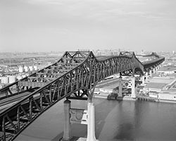
Carries 4 lanes of US 1/9 (no trucks) Crosses Passaic & Hackensack rivers Locale Jersey City, Kearny, Newark
New JerseyMaintained by NJDOT ID number 0704150/0901150 Design Steel deck truss cantilever bridge Total length 3.502 miles (5.636 km) Width 56 feet (17 m) Longest span 167.6 meters (550 ft) Vertical clearance 14.5 feet (4.4 m) Clearance below 550 feet (170 m) Opened November 24, 1932 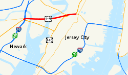
Coordinates Pulaski SkywayLocation: US 1/9
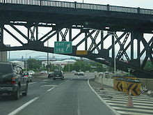
Route 139Governing body: NJDOT NRHP Reference#: 05000880[1] NJRHP #: 1526[2] Significant dates Added to NRHP: August 12, 2005 Designated NJRHP: June 13, 2005 The General Pulaski Skyway is a four-lane freeway composed of connected bridges in the northeastern part of the U.S. state of New Jersey, carrying the designation of U.S. Route 1/9 (US 1/9) for most of its length. The landmark structure has a total length of 3.502 mi (5.636 km) with the longest bridge spanning 550 ft (167.6 m). Travelling between Newark and Jersey City, the roadway crosses the Passaic and Hackensack rivers and Kearny Point, the peninsula between them. Trucks have been prohibited from using the Pulaski Skyway since 1934 and must use U.S. Route 1/9 Truck as an alternate route. As of 2010, the bridge handles about 67,000 crossings per day.
Designed by Sigvald Johannesson, the Pulaski Skyway opened in 1932 as the last part of the Route 1 Extension, one of the first superhighways in the United States that was intended to provide a connection to the Holland Tunnel. The skyway plans originally called for drawbridges at the river crossings, but these were later changed to high-level crossings as the road was intended to be used for high-speed traffic. It was named in 1933 for General Kazimierz Pułaski, a Polish general in the American Revolutionary War. One of several major projects built during the reign of Hudson County political boss Frank Hague, its construction was a source of political and labor disputes. A total of 15 people died in relation to the construction of the skyway. A median barrier was installed on the skyway in 1956 to reduce crashes. The bridges have been listed on the federal and state registers of historic places since 2005. They have been little altered since being built and not significantly repaired since 1984. In 2007, the New Jersey Department of Transportation (NJDOT) began a rehabilitation program which it estimates will cost about $1 billion.
Contents
Description
The four-lane skyway carries the US 1/9 overlap. While it generally runs east–west between Newark and Jersey City, it is signed according to US 1 and US 9 which are generally north–south routes. The west end of the skyway is near where Raymond Boulevard merges with the viaduct carrying the freeway in Newark's Ironbound. The east end is just beyond Tonnele Circle, where US 1/9 exits to the surface, following Tonnele Avenue towards the Lincoln Tunnel and George Washington Bridge. The road becomes the four-lane Route 139 which enters the lower part of the dual-level "divided highway" through Bergen Hill to the Holland Tunnel approach. In addition to crossing the Hackensack and Passaic rivers, it also passes over the New Jersey Turnpike, with which it has no interchange. Under most of the skyway is other vehicular, rail, maritime, and industrial infrastructure built on landfilled wetlands that were once part of the New Jersey Meadowlands.[3]
Sources differ on inclusion of the Route 1 Extension in the Pulaski Skyway.[4][5] In some cases, the NJDOT includes the southern approach starting at milepost 49.00.[6] Some maps, including a 1938 map of Newark and a 1981 map of Elizabeth also have the approach road labeled as the Pulaski Skyway.[7][8] Google includes the Holland Tunnel approach.[9] The National Register of Historic Places includes the road starting at milepost 51.25 extending to the dual-level highway at its northern end.[2][10] Other sources[11] such as the New York Times[12] and the Newark Star-Ledger[13] refer to the Pulaski Skyway as the 3.5-mile (5.6 km) iconic bridge designed by Johannesson that was the third and last component of the new highway to be built.
There is limited access to the freeway: Two single-lane ramps that rise to the inner lanes of the elevated structure, requiring traffic to enter or exit from the left[5] providing access at the Marion Section of Jersey City and South Kearny. Trucks have been prohibited for the "safety and welfare of the public"[14] since shortly after its official dedication. They are detoured to use U.S. Route 1/9 Truck, along the route of the Lincoln Highway that carried traffic before its construction. Pedestrians and bicycles are banned, as the road has no dedicated lanes or sidewalks. The speed limit on the skyway is 45 miles per hour (72 km/h),[6] but is not generally followed as there is nowhere for police to pull over speeders[15] due to the absence of shoulders.[5]
Before the 1953 highway renumbering in New Jersey, the skyway was also part of Route 25.[16] The original designation, part of the Route 1 Extension, referred to the Route 1 that largely became Route 25 in the 1927 renumbering.[17]
Design and construction
Except for the crossings of the Hackensack and Passaic rivers, the main part of the skyway is a steel deck truss cantilever bridge, supported by concrete piers. Each of the two river crossings is a 1,250-foot (380 m) combination of a 550-foot (170 m) subdivided (K-shaped) through Pratt truss between the supports and a 350-foot (110 m) basic Pratt truss structure connecting each end to the deck truss part of the skyway.[18] Spanning the rivers, they reach a height of 135 feet (41 m).[19] The Jersey City end includes three short through truss spans that take the roadway over rail lines. The westernmost passes over the Port Authority Trans-Hudson rapid transit line and Conrail's Passaic and Harsimus Line. Just beyond are the two easternmost deck truss spans, after which the skyway is low enough to use simple vertical supports. After crossing over Tonnele Circle, the highway passes under Kennedy Boulevard and enters the cut excavated through Bergen Hill that accommodates Route 139.[20]
Design for the Holland Tunnel, the first fixed roadway connection between New Jersey and New York City, began in 1919; construction began in 1922, and the tunnel opened in late 1927.[21] In order to provide for a continuous highway connection on the New Jersey side the New Jersey Legislature passed a bill authorizing the extension of Route 1 from its end at Elizabeth through Newark and Jersey City to the proposed tunnel.[22] It was conceived as the nations's first "super-highway".[23] State highway engineer Hugh L. Sloan appointed old acquaintance Fred Lavis, a consulting engineer who had worked on foreign rail lines and the Panama Canal and written four books on locating and designing rail lines, to design this Route 1 Extension.[24] The Skyway portion was designed by Sigvald Johannesson.[19]
Frank Hague, mayor of Jersey City and boss of the state's political machine, directed the state to avoid the open cuts that were already common where the railroads crossed Bergen Hill, and to include an access ramp in Kearny to spur industrial development.[25] Construction of the highway, which was mostly raised on embankments, and passed through Bergen Hill in a cut began in mid-1925, and large portions in Jersey City and Newark—including the "covered roadway" (Route 139) and the embankment in eastern Newark—were opened in late 1928, about a year after the tunnel opened.[26] Traffic was still required to cross the Hackensack and Passaic Rivers on the old Lincoln Highway, which included two drawbridges that frequently stopped traffic to allow ships to pass.[24]
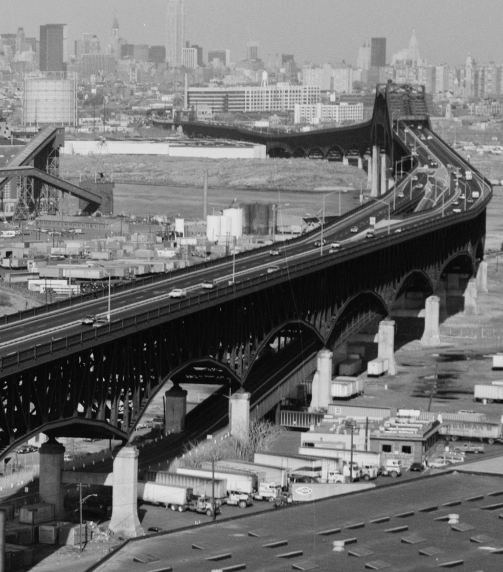
 US 1/9 is elevated through eastern Newark, but the skyway (background) rises higher to clear the rivers.
Lavis's design for this section across the New Jersey Meadowlands, which would be raised on concrete piers, included two drawbridges 35 feet (11 m) above the water surface, sufficient for the majority of ships to pass underneath. He resigned in 1928, believing his work was complete, but in January 1929 the War Department objected to the continued existence of the Lincoln Highway bridges once the new highway was complete. Since the Route 1 Extension was not intended for local traffic, and replacing the drawbridges with tunnels would be expensive, a compromise was worked out by late 1929 to raise the bridges to 135 feet (41 m). The concrete jacketing of the steel was removed from the plans, since the taller bridges would be heavier; this resulted in more future maintenance.[24]
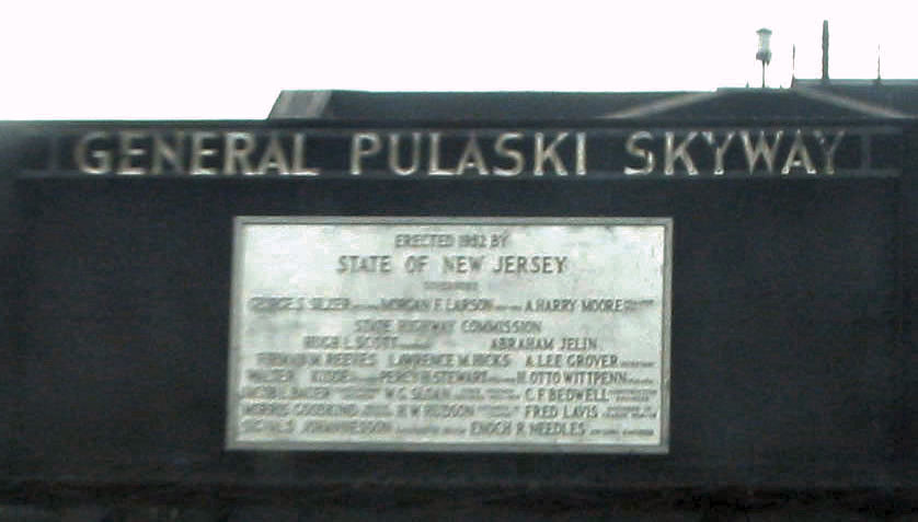
Four companies—the American Bridge Company, McClintic-Marshall Company, Phoenix Bridge Company, and Taylor-Fichter Steel Construction Company—were awarded contracts for the so-called "Diagonal Highway", with construction to start in April 1930. The two river bridges, McClintic-Marshall's portion, were completed first,[27][28] and the $21 million[29] road was opened at 8:00 a.m. on November 24, 1932, Thanksgiving Day, after an official ceremony the previous day on the Kearny ramp.[30][31] Owing to the Great Depression and problems with funding, Governor A. Harry Moore directed the Highway Commission on October 25, 1932 to make a formal request to the U.S. Bureau of Public Roads to charge tolls on the Diagonal Highway. It was thought that tolls would be illegal due to federal aid being used to build the road, but it might be possible to transfer the $600,000 of federal aid to another project.[32] A bill was introduced into the state legislature on May 1, 1933 asking to add tolls to the road (then known as the "sky way"), at a rate of 10 cents for cars and 20 cents for trucks. The legal obstacle of federal aid was also resolved by getting approval to transfer the funds,[33] but tolls were never added.[citation needed]
 A plaque honoring Pulaski
During planning and construction, and for about half a year after opening, the road had no official name, being known as the Diagonal Highway, Newark – Jersey City Viaduct, or High-Level Viaduct. On May 3, 1933, the New Jersey Legislature passed a bill sponsored by Assemblyman Eugene W. Hejke of Jersey City naming the road after Kazimierz Pułaski, the Polish military leader who helped train and lead Continental Army troops in the American Revolutionary War.[34] An official ceremony was held on October 11, 1933, including the unveiling of signs with the new designation.[35]
A survey taken during 1933 proved that the road saved time. Not only was the distance shortened by 0.5 miles (0.80 km), but it took about six minutes less to travel the new route. Trucks gained even more time, saving anywhere from five to eleven minutes. It was found that the highway also diverted a good deal of traffic from other routes.[36]
Labor issues
The construction of the Pulaski Skyway ended up causing a dispute between Mayor of Jersey City Frank Hague, who ran a statewide political machine, and Theodore M. Brandle, a "labor czar" allied with Hague. Brandle and Hague had become friends through Hague's efforts to get the approval of unions. Brandle helped organize the Branleygran Company, a construction bond underwriter, which Hague channeled construction projects towards. During the mid-1920s redevelopment of Journal Square, Brandle's Labor National Bank, founded in June 1926, acquired a new 15-story headquarters, the Labor Bank Building. Essentially Brandle controlled any construction projects in northern New Jersey, and any strikes he might call would be backed by Hague's police.[37]
The relationship between Hague and Brandle started to go bad in late 1931, during the construction of the Jersey City Medical Center, an important project to Hague. Leo Brennan, a contractor approved by Hague without consulting Brandle, who was building a backup power station for the hospital, refused to work with Brandle's card-file system, by which he kept track of union members and blacklisted those whom he disliked. The annoyed Brandle called a strike, but Brennan's workers refused; the police shut down the site after a brawl, but Brennan got court approval to continue. To placate Brandle, who threatened a strike that would stop all construction work on the center, Hague paid off Brennan and hired another contractor that Brandle had approved.[38]
For the construction of the Pulaski Skyway, which began in April 1930, Hague chose four members of the National Erectors' Association, an organization of "open shop" (anti-union) steel contractors. Performance bonds were paid in cash, bypassing Branleygran, and the companies hired the Foster Industrial and Detective Agency to guard the site against Brandle's threat to "unionize this job or else". Brandle organized picket lines of loyal union men, and the two sides frequently fought in the streets or in the work area. Brandle's sole victory was a five-day stoppage in July 1931 by 165 non-union workers, who were interested in higher pay and afraid of the ongoing fights, but decided against joining the union.[39] During the LaFollette Civil Liberties Committee hearings, it was discovered that, in order to save about $50,000 in salary, the American Bridge Company, one of the four contractors, spent almost $300,000 on keeping its "open shop".[40]
The first casualty of the labor battle was a picketer, shot and temporarily paralyzed by a perimeter guard on November 14, 1931 for throwing stones at workers. Several months later, on February 27, 1932, a car carrying six workers to the construction site was surrounded by union men, who began to beat them with iron bars. One of the workers, William T. Harrison, was dead by the next morning; Hague broke all ties with Brandle and ordered the police to "wage relentless war against the Brandle gang-rioters". In April 1932, 21 ironworkers were indicted as suspects in the Harrison murder.[41] The trial was held on December 6, 1932, two weeks after the completion of the skyway. Every defendant was found not guilty, since county prosecutor John Drewen was unable to place any of them at the scene of the crime, and witnesses and defendants testified that they had been forced under torture or the threat of prosecution to sign affidavits and confessions.[42] In addition to the death of William T. Harrison, 14 lives were claimed by work-related accidents during construction.[43]
Hague refused to allow Brandle and the unions to win, and began to force unions to foreclose through his control of the courts. On the public side, Hague attacked the "labor racketeers" with words, and the local newspapers gladly went along. In 1937 and 1938, Hague turned Jersey City into a police state to fight the Congress of Industrial Organizations (CIO), which was trying to inform workers of their rights under the 1935 National Labor Relations Act. Socialist Norman Thomas was prevented from speaking in Jersey City and Newark by Hague and his friends.[44] This and other similar cases turned the national spotlight on Hague, and he was attacked by the New Yorker and Life in early 1938. Finally, in 1947, Governor Alfred E. Driscoll cut off Hague's judicial power, and the mayor retired.[45]
Truck and other safety issues
 The Kearny ramp, which was built to promote industrial development but proved too dangerous for trucks
The slippery concrete surfacing, steep left-side ramps, center breakdown lane, and wide-open alignment built for high speeds all contributed to a high number of crashes. Mayor Frank Hague of Jersey City passed an ordinance in November 1933 banning trucks from its section of the skyway, which effectively banned them from the whole road.[46] Enforcement began on January 15, 1934, when Jersey City police began arresting truck drivers using the skyway.[47] The New Jersey State Highway Commission approved the ban on January 23.[48][49]
As a result of controversy caused by the ban, on February 6, 300,000 ballots were distributed to motorists on the skyway, asking whether trucks should be banned. Mayor Hague promised to go with the majority,[50] which agreed with the ban. The matter was also taken to court, with one of the truck drivers convicted arguing that the ban was an unreasonable restraint of interstate commerce, and that since the federal government contributed money towards the road, Jersey City lacked the power to ban trucks. On August 14, Justice Thomas W. Trenchard of the New Jersey Supreme Court upheld the ban, stating that "the court is not at liberty to substitute its judgment for that of the municipality's as to the best and most feasible manner of curing traffic evils and traffic congestion where such regulation bears a direct relationship to public safety and is reasonable and not arbitrary."[51] The Tonnele Circle Viaduct, a new offramp allowing trucks from the Holland Tunnel to bypass Tonnele Circle, opened in September 1938.[52]
On May 21, 1952, large numbers of trucks were spotted by Jersey City police entering the city on the skyway. Upon pulling over the drivers, they were told that the exit in Newark for the truck route was closed for construction. A call to Newark police confirmed the situation. Hudson County police refused to force trucks to exit before Jersey City, since there was no state law banning trucks from the skyway. Jersey City Police Chief James McNamara gave in, and trucks were temporarily allowed to use the skyway, though only in one direction.[53]
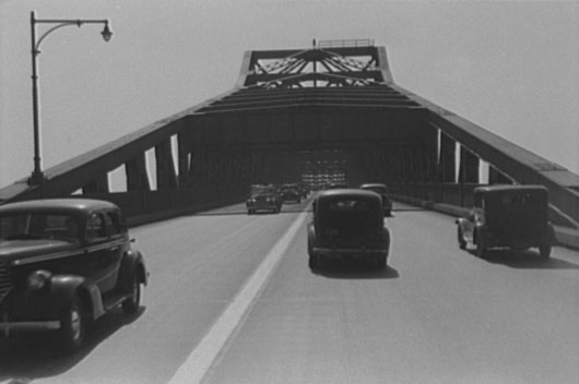
 1941 photo, before the median barrier was installed
When the road was first opened, it carried five lanes; the center one was intended as a breakdown lane, but was in actuality used as a suicide lane for passing slower traffic.[49] By the 1950s, the skyway was seeing over 400 crashes per year; an aluminum median barrier was added in mid-1956, in addition to a new coat of pavement designed to make the road less slippery.[54][55][56]
 The New Jersey Turnpike under the skyway; photo from 2004, before the lowering
The skyway was a constraint in the building of the north–south New Jersey Turnpike near the west end in 1951. The turnpike had to be built low enough to provide enough clearance underneath the skyway, but high enough to clear the nearby Passaic River. Turnpike engineers could have built over the skyway (at a much higher cost) or built under the skyway's trusses; the latter option was chosen.[57][58] The Newark Bay Extension of the New Jersey Turnpike (I-78) opened in September 1956, finally allowing Holland Tunnel-bound trucks to bypass the old surface road.[59] As part of a 2005 seismic retrofit project, the Turnpike Authority lowered its bridge to increase vertical clearance and allow for full-width shoulders, which had been constrained by the location of the skyway supports.[60]
In the aftermath of the I-35W Mississippi River bridge collapse in Minneapolis, Minnesota in August 2007, local officials called for a renovation of the skyway and its non-redundant trusses. The work, aimed at preventing metal fatigue and other structural instabilities that are believed to have caused the Minneapolis disaster, was expected to cost $10 million and take one year to complete.[61] The New Jersey Department of Transportation (NJDOT) identified the skyway in 2008 as one of eight "high priority" bridges in need of repairs.[62] After work began it was determined that the repairs needed were more extensive, costly, time-consuming than than expected, and the agency estimates rehabilitation will cost approximately $1–1.3 billion.[3][63] Work has proceeded without the closure of the roadway, but rather alternate lane closings[64][65][66] affecting the 67,000 daily crossings.[3] In 2009, NJDOT has installed nets to catch falling pieces of the structure. The department spends tens of millions of dollars each year in maintenance on the skyway and estimates that it would take a decade before the state could afford to rehabilitate or replace the structure.[67]
In popular culture
The Pulaski Skyway has been used in radio, film, television, and at least one video game. The 1938 radio drama The War of the Worlds, one of the Martian machines straddles the skyway (a scene replicated in the 2005 film wherein the first machine appears in the shadow of the bridge). It was featured in the 1979 film Hair.[11] Alfred Hitchcock's 1943 film Shadow of a Doubt and the 1999–2007 television drama The Sopranos includes shots of the bridge in the opening montages.[68] Clutch included the track "Pulaski Skyway" on its 2005 release Robot Hive/Exodus. [69] In the 2008 Rockstar video game Grand Theft Auto IV, the borough of Alderney (modeled after portions of northern New Jersey, including Newark and Jersey City) contains a navigable elevated highway named Plumbers Skyway, which bears strong resemblance to the Pulaski Skyway.[citation needed]
See also
- List of bridges, tunnels, and cuts in Hudson County, New Jersey
- List of crossings of the Hackensack River
References
- ^ "National Register Information System". National Register of Historic Places. National Park Service. March 13, 2009. http://nrhp.focus.nps.gov/natreg/docs/All_Data.html.
- ^ a b Staff (July 7, 2009). "New Jersey and National Registers of Historic Places" (PDF). New Jersey Department of Environmental Protection Historic Preservation Office. p. 6. http://www.state.nj.us/dep/hpo/1identify/lists/hudson.pdf. Retrieved September 18, 2010.
- ^ a b c Staff (2010). "Pulaski Skyway Overview" (PDF). New Jersey Department of Transportation. http://www.state.nj.us/transportation/works/studies/pulaski/. Retrieved September 25, 2010.
- ^ Richman, Steven M. (2005). The Bridges of New Jersey: Portraits of Garden State Crossings. Piscataway, NJ: Rutgers University Press. p. 105. http://books.google.nl/books?id=5V2lnUoPXo4C&pg=PA105&dq=pulaski+skyway+cantilever+sigvald&hl=en&ei=TrOjTOfGIobLOOG9yYUE&sa=X&oi=book_result&ct=result&resnum=5&ved=0CDkQ6AEwBA#v=onepage&q=pulaski%20skyway%20cantilever%20sigvald&f=false.
- ^ a b c Staff (2010). "Pulaski Skyway History". New Jersey Department of Transportation. http://www.state.nj.us/transportation/works/studies/pulaski/history.shtm. Retrieved September 25, 2010.
- ^ a b New Jersey Department of Transportation (May 2009) (PDF). US 1 (South to North) (Map). Straight Line Diagrams. http://www.state.nj.us/transportation/refdata/sldiag/00000001__-.pdf. Retrieved September 3, 2010.
- ^ Price & Lee Co. (1938). Map of the City of Newark, NJ (Map). http://mapmaker.rutgers.edu/NEWARK/Newark_1938.jpg. Retrieved October 14, 2010.
- ^ United States Geological Survey (1981). Elizabeth, NJ– NY (Map). http://elibrary.rutgers.edu/quadpage/viewmaps/drgfiles/040074F2.jpg. Retrieved October 14, 2010.
- ^ Google, Inc. Google Maps – Jersey City, NJ (Map). Cartography by Google, Inc. http://maps.google.com/maps?ll=40.7322,-74.0645&spn=0.01,0.01&t=m&q=40.7322,-74.0645. Retrieved October 16, 2010.
- ^ Staff (August 31, 2010). "National Register". National Register of Historic Places. National Park Service. http://nrhp.focus.nps.gov/natreghome.do?searchtype=natreghome. Retrieved October 1, 2010.
- ^ a b Karnoutsos, Carmela; Shalhoub, Patrick (2007). "General Casimir Pulaski Memorial Skyway". Jersey City Past and Present. New Jersey City University. http://www.njcu.edu/programs/jchistory/pages/p_pages/pulaski_skyway.htm. Retrieved October 1, 2010.
- ^ Kocieniewski, David (July 24, 2009). "Many Failing Roads, Little Repair Money". New York Times. http://www.nytimes.com/2009/07/26/nyregion/26roads.html?_r=1&scp=13&sq=skyway&st=nyt. Retrieved October 1, 2010.
- ^ Feeney, Tom C. (August 27, 2007). "Work Set to Begin on Pulaski Skyway". Star-Ledger (Newark, NJ). http://blog.nj.com/ledgerupdates/2007/08/after_50_million_facelift_skyw.html. Retrieved October 1, 2010.
- ^ Staff (October 29, 2003). "Traffic Regulations: Route 1 and 9, the Pulaski Skyway". New Jersey Department of Transportation. http://www.state.nj.us/transportation/refdata/traffic_orders/access/rt1_9.shtm. Retrieved October 27, 2007.
- ^ Hart, p. 55.
- ^ Rand McNally (1946). Road Atlas (Map). p. 42, New York and Vicinity inset. http://www.broermapsonline.org/members/NorthAmerica/UnitedStates/Midatlantic/NewYork/NewYorkCity/randmcnally_ra_1946_040.html. Retrieved September 25, 2010.
- ^ Rand McNally (1926). Auto Road Atlas (Map). p. 86, New York and Vicinity inset. http://www.broermapsonline.org/members/NorthAmerica/UnitedStates/Midatlantic/NewYork/NewYorkCity/unitedstates1926ra_078.html. Retrieved September 25, 2010.
- ^ Condit, Carl W. (1961). American Building Art: The Twentieth Century. New York: Oxford University Press. OCLC 558616043. http://books.google.nl/books?id=0sIVAAAAMAAJ&q=pulaski+skyway+cantilever+sigvald&dq=pulaski+skyway+cantilever+sigvald&hl=en&ei=nayhTOPGOtSBOPeWsI4E&sa=X&oi=book_result&ct=result&resnum=6&ved=0CEAQ6AEwBQ. quoted in Hart, pp. 50–51.
- ^ a b Staff. "General Pulaski Skyway". Jersey City A to Z. New Jersey City University. http://www.njcu.edu/programs/jchistory/Pages/P_Pages/Pulaski_Skyway.htm. Retrieved September 16, 2010.
- ^ Google, Inc. Google Maps – 3D Map of Tonrele Circle (Map). Cartography by Google, Inc. http://maps.google.com/maps?f=q&source=s_q&hl=en&q=Tonnele+Ave,+North+Bergen,+New+Jersey&sll=37.0625,-95.677068&sspn=64.409204,59.589844&ie=UTF8&cd=1&geocode=FaYmbgIdlzaW-w&split=0&hq=&hnear=Tonnele+Ave,+North+Bergen,+New+Jersey&ll=40.741599,-74.06626&spn=0.015363,0.014548&t=f&z=16&ecpose=40.73630755,-74.06625971,602.3,-0.001,44.972,0. Retrieved September 25, 2010.
- ^ Hart, pp. 10, 22.
- ^ Public Law 1922, Chapter 253
- ^ Hart, pp. 1–5.
- ^ a b c Hart, pp. 57–73.
- ^ Hart, p.188.
- ^ "Jersey's Super Road to Be Opened Today". The New York Times: p. XX12. December 16, 1928. http://select.nytimes.com/gst/abstract.html?res=F70816F9395E1B728DDDAF0994DA415B888EF1D3. Retrieved September 25, 2010. (subscription required)
- ^ Hart, p. 103.
- ^ Hart, p. 123.
- ^ Hart, p. 4.
- ^ "Auto Express Route Dedicated in Jersey". The New York Times: p. 27. November 24, 1932. http://select.nytimes.com/gst/abstract.html?res=F70A16F6355516738DDDAD0A94D9415B828FF1D3. Retrieved September 25, 2010. (subscription required)
- ^ Hart, pp. 132–136.
- ^ "Jersey Forces Toll Issue". The New York Times: p. 4. October 26, 1932. http://select.nytimes.com/gst/abstract.html?res=F20814FE3A5513738DDDAF0A94D8415B828FF1D3. Retrieved September 25, 2010. (subscription required)
- ^ "Tolls on Viaduct Set by Jersey Bill". The New York Times: p. 7. May 2, 1933. http://select.nytimes.com/gst/abstract.html?res=F00610F73F5C16738DDDAB0894DD405B838FF1D3. Retrieved September 25, 2010. (subscription required)
- ^ "Jersey Honors Pulaski". The New York Times: p. 19. May 4, 1933. http://select.nytimes.com/gst/abstract.html?res=F00B15F83D5E1A7A93C6A9178ED85F478385F9. Retrieved September 25, 2010. (subscription required)
- ^ Hart, pp. 155–159.
- ^ Yordan, E.L. (March 18, 1934). "Raised Way Saves Time". The New York Times: p. XX8. http://select.nytimes.com/gst/abstract.html?res=F20711FB385A107A93CAA81788D85F408385F9. Retrieved September 25, 2010. (subscription required)
- ^ Hart, pp. 87–92.
- ^ Hart, pp. 89, 92–95.
- ^ Hart, pp. 101–113.
- ^ Hart, pp. 151–153.
- ^ Hart, pp. 116–121.
- ^ Hart, pp. 137–143.
- ^ Hart, p. 112.
- ^ Hart, pp. 143–151.
- ^ Hart, pp. 169–172, 175–176.
- ^ "Bars Trucks on Skyway" (Subscription required). The New York Times: p. 17. January 9, 1934. http://select.nytimes.com/gst/abstract.html?res=FB0F1EFC3559177A93CBA9178AD85F408385F9. Retrieved September 25, 2010.
- ^ "10 Held in Skyway Ban". The New York Times: p. 12. January 16, 1934. http://select.nytimes.com/gst/abstract.html?res=FB0610F83F5D167A93C4A8178AD85F408385F9. Retrieved September 25, 2010. (subscription required)
- ^ "Skyway Truck Ban Approved by State". The New York Times: p. 19. January 24, 1932. http://select.nytimes.com/gst/abstract.html?res=FB0D16FE3E5D167A93C6AB178AD85F408385F9. Retrieved September 25, 2010. (subscription required)
- ^ a b Hart, pp. 160–163.
- ^ "Skyway Ban Up for Vote". The New York Times: p. 10. February 7, 1934. http://select.nytimes.com/gst/abstract.html?res=F50914FC3E5D167A93C5A91789D85F408385F9. Retrieved September 25, 2010. (subscription required)
- ^ "Skyway Truck Ban Upheld in Jersey". The New York Times: p. 7. August 15, 1934. http://select.nytimes.com/gst/abstract.html?res=FA0711FA385D167A93C7A81783D85F408385F9. Retrieved September 25, 2010. (subscription required)
- ^ "New Viaduct Opened in Jersey". The New York Times: p. 25. September 15, 1938. http://select.nytimes.com/gst/abstract.html?res=FB0D1EF93E55157A93C7A81782D85F4C8385F9. Retrieved September 25, 2010. (subscription required)
- ^ "Banned Trucks Roll Along Pulaski Skyway While Jersey City Police Fume All in Vain". The New York Times: p. 29. May 22, 1952. http://select.nytimes.com/gst/abstract.html?res=FA0810F73E58177B93C0AB178ED85F468585F9. Retrieved September 25, 2010. (subscription required)
- ^ "Pulaski Skyway to Get New and Safer Surface". The New York Times: p. 26. September 13, 1955. http://select.nytimes.com/gst/abstract.html?res=F10B16FE395B117A93C1A81782D85F418585F9. Retrieved September 25, 2010. (subscription required)
- ^ "Skyway Job to Cause Detour". The New York Times: p. 23. June 4, 1956. http://select.nytimes.com/gst/abstract.html?res=F70612FC3D5B157B93C6A9178DD85F428585F9. Retrieved September 25, 2010. (subscription required)
- ^ Hart, pp. 166–167.
- ^ Schwab, Armand, Jr. (January 20, 1952). "City Linked to Super-Highway". The New York Times: p. X17. http://select.nytimes.com/gst/abstract.html?res=F20E1FF83858107A93C2AB178AD85F468585F9. Retrieved September 25, 2010. (subscription required)
- ^ Hart, p. 173–174.
- ^ Ingraham, Joseph C work= The New York Times (September 9, 1956). "Bypass in Bayonne". p. X21. http://select.nytimes.com/gst/abstract.html?res=F10610F83A5815738FDDA00894D1405B8689F1D3. Retrieved September 25, 2010. (subscription required)
- ^ Staff (March 6, 2006). "35th Annual Engineering Excellence Awards Dinner program" (PDF). American Council of Engineering Companies of New Jersey. http://www.acecnj.org/Docs/2006%20acec%20award%20program.pdf. Retrieved October 27, 2007.
- ^ Davis, Tom (August 20, 2007). "Pulaski Skyway, at 75, to get first wave of critical repairs". The Record (Hackensack, NJ). Archived from the original on October 13, 2007. http://web.archive.org/web/20071013171853/http://www.northjersey.com/page.php?qstr=eXJpcnk3ZjczN2Y3dnFlZUVFeXk2MDgmZmdiZWw3Zjd2cWVlRUV5eTcxODQxODUmeXJpcnk3ZjcxN2Y3dnFlZUVFeXky. Retrieved October 27, 2007.
- ^ Buettner, Russ (August 11, 2007). "After Minneapolis Disaster, Concerns About the Pulaski Skyway". The New York Times. http://www.nytimes.com/2007/08/11/nyregion/11pulaski.html. Retrieved August 22, 2008.
- ^ Feeney, Tom C. (February 25, 2008). "Pulaski Skyway Repairs Will Cost Millions more than First Thought". The Star-Ledger (Newark, NJ). http://www.nj.com/news/index.ssf/2008/02/pulaski_skyway_repairs_will_co.html. Retrieved September 25, 2010.
- ^ "NJDOT Announces Pulaski Skyway Lane and Ramp Closures" (Press release). New Jersey Department of Transportation. March 7, 2008. http://www.state.nj.us/transportation/about/press/2008/030708.shtm. Retrieved September 25, 2010.
- ^ "Overnight Lane Closures Planned for Pulaski Skyway". The Jersey Journal (Jersey City, NJ). September 3, 2010. http://www.nj.com/hudson/index.ssf/2010/09/overnight_lane_closures_planne.html. Retrieved September 25, 2010.
- ^ "Short-Term Repairs Underway" (PDF). Pulaski Skyway Rehabilitation (New Jersey Department of Transportation) 2 (Winter 2010). February 12, 2010. http://www.state.nj.us/transportation/works/studies/pulaski/pdf/newsletterwinter2010.pdf. Retrieved September 25, 2010.
- ^ Kocieniewski, David (July 26, 2009). "Many Failing Roads, Little Repair Money". The New York Times: p. 1L.
- ^ Hart, pp. 51–52.
- ^ Clutch (2005). RobotHive/Exodus (Audio Compact Disc). DRT Entertainment.
Works cited
- Hart, Steven (2007). The Last Three Miles: Politics, Murder, and the Construction of America's First Superhighway. New York: The New Press. ISBN 978-1-59558-098-6.
External links
- Historic American Engineering Record: Pulaski Skyway, Spanning Passaic & Hackensack Rivers, Jersey City, Hudson County, NJ
- NYCroads website: Pulaski Skyway
- Pulaski Skyway at Structurae
U.S. National Register of Historic Places Topics Lists by states Alabama • Alaska • Arizona • Arkansas • California • Colorado • Connecticut • Delaware • Florida • Georgia • Hawaii • Idaho • Illinois • Indiana • Iowa • Kansas • Kentucky • Louisiana • Maine • Maryland • Massachusetts • Michigan • Minnesota • Mississippi • Missouri • Montana • Nebraska • Nevada • New Hampshire • New Jersey • New Mexico • New York • North Carolina • North Dakota • Ohio • Oklahoma • Oregon • Pennsylvania • Rhode Island • South Carolina • South Dakota • Tennessee • Texas • Utah • Vermont • Virginia • Washington • West Virginia • Wisconsin • WyomingLists by territories Lists by associated states Other Categories:- Historic districts in the United States
- Cantilever bridges
- Bridges completed in 1932
- Hackensack River
- Passaic River
- U.S. Route 1
- U.S. Route 9
- Transportation in Newark, New Jersey
- Transportation in Jersey City, New Jersey
- Transportation in Hudson County, New Jersey
- Bridges on the National Register of Historic Places in New Jersey
- Historic districts in Hudson County, New Jersey
- Road bridges in New Jersey


Wikimedia Foundation. 2010.