- Banjul
Infobox Settlement
official_name = Banjul
other_name =
native_name =
nickname =
settlement_type =
motto =
imagesize =300px
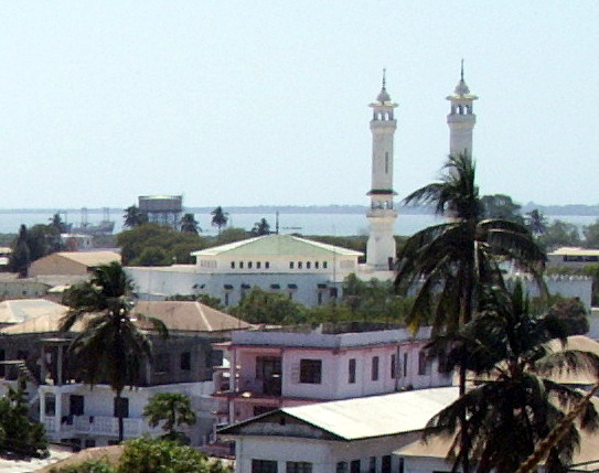
image_caption = Banjul King Fahad Mosque
flag_size =
image_
seal_size =
image_shield =
shield_size =
city_logo =
citylogo_size =
mapsize = 275px
map_caption = Location of Banjul in The Gambia
mapsize1 =
map_caption1 =
image_dot_
dot_mapsize =
dot_map_caption =
dot_x = |dot_y =
pushpin_
pushpin_label_position =
pushpin_mapsize =300
pushpin_map_caption =
subdivision_type = Country
subdivision_name =The Gambia
subdivision_type1 = Division
subdivision_name1 = Banjul
subdivision_type2 =
subdivision_name2 =
subdivision_type3 =
subdivision_name3 =
subdivision_type4 =
subdivision_name4 =
government_footnotes =
government_type =
leader_title =
leader_name =
leader_title1 =
leader_name1 =
leader_title2 =
leader_name2 =
leader_title3 =
leader_name3 =
leader_title4 =
leader_name4 =
established_title =
established_date =
established_title2 =
established_date2 =
established_title3 =
established_date3 =
area_magnitude =
unit_pref =Imperial
area_footnotes =
area_total_km2 =
area_land_km2 =
area_water_km2 =
area_total_sq_mi =
area_land_sq_mi =
area_water_sq_mi =
area_water_percent =
area_urban_km2 =93
area_urban_sq_mi =
area_metro_km2 =
area_metro_sq_mi =
population_as_of =2003
population_footnotes =
population_note =
population_total =34,828
population_density_km2 =
population_density_sq_mi =
population_metro =
population_density_metro_km2 =
population_density_metro_sq_mi =
population_urban =357,238
population_density_urban_km2 =
population_density_urban_sq_mi =
population_blank1_title =
population_blank1 =
population_density_blank1_km2 =
population_density_blank1_sq_mi =
timezone =
utc_offset =
timezone_DST =
utc_offset_DST =
latd=13|latm=27 |lats=11 |latNS=N
longd=16 |longm=34 |longs=39 |longEW=W
elevation_footnotes =
elevation_m =
elevation_ft =
postal_code_type =
postal_code =
area_code =
blank_name =
blank_info =
blank1_name =
blank1_info =
website =
footnotes =Banjul (formerly Bathurst), officially the City of Banjul, is the
capital ofThe Gambia , and located within the division of the same name. The population of the city proper is only 34,828, with the Greater Banjul Area, which includes the City of Banjul and the Kanifing Municipal Council, at a population of 357,238 (2003 census). It is located on St Mary's Island (Banjul Island) where theGambia River enters theAtlantic Ocean . The island is connected to the mainland by passenger and vehicle ferries to the north and bridges to the south.History
In
1816 , the British founded Banjul as a trading post and base for suppressing the slave trade. It was first named "Bathurst" after Henry Bathurst, the secretary of the British Colonial Office, but was changed to Banjul in1973 .On
July 22 ,1994 , Banjul was the scene of a bloodless militarycoup d'état in which PresidentDawda Jawara was overthrown and replaced by the country's current (and twice reelected) PresidentYahya Jammeh . To commemorate this event,Arch 22 was built as an entrance portal to the capital. The gate is 35 meters tall and the centre of an open square. It houses atextile museum .Attractions in the city include the
Gambian National Museum , theAlbert Market ,Banjul State House ,Banjul Court House , twocathedral s and several majormosque s.Economy
Banjul is the main urban area of The Gambia and holds the country's economic and administrative center including the
Central Bank of The Gambia . As the fourth most densely populated country in Africa, The Gambia has more than one urban area. Peanut processing is the country's principal industry, but bee's wax, palm wood,palm oil , and skins and hides are also shipped from its port. View of Banjul from Arch 22.The museum also includes hand written pages from the Quoran and explains a lot of Juju "magic".Climate
Banjul has a hot climate all year round due to the Sahara Desert. The coldest month is august and the hottest is March.
Infobox Weather
collapsed=
metric_first=
single_line=
location = Banjul
Jan_Hi_°C = 31
Feb_Hi_°C = 32
Mar_Hi_°C = 34
Apr_Hi_°C = 33
May_Hi_°C = 32
Jun_Hi_°C = 32
Jul_Hi_°C = 30
Aug_Hi_°C = 29
Sep_Hi_°C = 31
Oct_Hi_°C = 32
Nov_Hi_°C = 32
Dec_Hi_°C = 31Jan_Lo_°C = 15
Feb_Lo_°C = 16
Mar_Lo_°C = 17
Apr_Lo_°C = 18
May_Lo_°C = 19
Jun_Lo_°C = 23
Jul_Lo_°C = 23
Aug_Lo_°C = 23
Sep_Lo_°C = 23
Oct_Lo_°C = 22
Nov_Lo_°C = 18
Dec_Lo_°C = 16
source = cite web
url = | title = | accessmonthday = | accessyear =
publisher = | language = ]
accessdate =
source2 = cite web
url = | title = | accessmonthday = | accessyear =
publisher = | language = ]
accessdate2 =Transport
Ferries sail from Banjul to Barra. The city is served by the
Banjul International Airport . Banjul is on theTrans-West African Coastal Highway connecting it to Dakar and Bissau (Guinea-Bissau ), and will eventually provide a paved highway link to 11 other nations ofECOWAS .Districts
Banjul Division (Greater Banjul Area) is divided into 2
district s:
*Banjul
*Kanifing Twinned cities
Banjul is twinned with
Grimsby in the UK andNewark, New Jersey in theUnited States . It is the destination of thePlymouth-Banjul Challenge , a charity road rally.ee also
*
Divisions of The Gambia
*Districts of The Gambia References
External links
* [http://www.accessgambia.com/ Access Gambia - Hotels, News, Travel & Photos]
* [http://www.wow.gm WOW-Gambia News and Information]
* [http://www.gambianow.com/home Gambia Site with history of Banjul]
* [http://www.gambianow.com/news Gambia News]
Wikimedia Foundation. 2010.

