- Bound Brook, New Jersey
Infobox Settlement
official_name = Bound Brook, New Jersey
settlement_type = Borough
nickname =
motto =
imagesize =
image_caption =
image_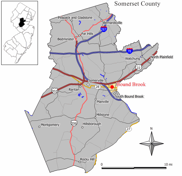
mapsize = 250x200px
map_caption = Map showing location of Bound Brook in Somerset County
mapsize1 =
map_caption1 =subdivision_type = Country
subdivision_name =United States
subdivision_type1 = State
subdivision_name1 =New Jersey
subdivision_type2 = County
subdivision_name2 = Somerset
government_footnotes =
government_type =Borough (New Jersey)
leader_title =Mayor
leader_name = Carey Pilato (2011)
leader_title1 = Administrator
leader_name1 = Randy Bahr (interim) [ [http://www.boundbrooknj.net/6101/index.html Bound Brook Borough Hall] , Borough of Bound Brook. AccessedApril 29 ,2008 .]
established_title = Incorporated
established_date =February 11 ,1891 unit_pref = Imperial
area_footnotes =
area_magnitude =
area_total_km2 = 4.4
area_land_km2 = 4.4
area_water_km2 = 0.0
area_total_sq_mi = 1.7
area_land_sq_mi = 1.7
area_water_sq_mi = 0.0population_as_of = 2006
population_footnotes =
population_total = 10168
population_density_km2 = 2298.7
population_density_sq_mi = 5953.7timezone = Eastern (EST)
utc_offset = -5
timezone_DST = EDT
utc_offset_DST = -4
elevation_footnotes = [Gnis|885166|Borough of Bound Brook,Geographic Names Information System . AccessedJanuary 4 ,2008 .]
elevation_m = 13
elevation_ft = 43
latd = 40 |latm = 34 |lats = 03 |latNS = N
longd = 74 |longm = 32 |longs = 15 |longEW = Wpostal_code_type =
ZIP code
postal_code = 08805
area_code = 732
blank_name = FIPS code
blank_info = 34-06790GR|2 [ [http://mcdc2.missouri.edu/webrepts/commoncodes/ccc_nj.html A Cure for the Common Codes: New Jersey] , Missouri Census Data Center. AccessedJuly 14 ,2008 .]
blank1_name = GNIS feature ID
blank1_info = 0874865GR|3
website = http://www.boundbrooknj.net
footnotes =Bound Brook is a borough in Somerset County,
New Jersey ,United States . As of theUnited States 2000 Census , the borough population was 10,155.Bound Brook was originally incorporated as a town by an Act of the
New Jersey Legislature onMarch 24 ,1869 , within portions of Bridgewater Township. OnFebruary 11 ,1891 , it was incorporated as a borough, based on the results of a referendum held on the previous day."The Story of New Jersey's Civil Boundaries: 1606-1968", John P. Snyder, Bureau of Geology and Topography; Trenton, New Jersey; 1969. p. 222.] [ [http://www.boundbrooknj.net/ The Borough of Bound Brook Municipal Resource] , Borough of Bound Brook. AccessedApril 29 ,2008 .]History
The town was first settled in 1681, and was established near the Bound Brook stream of the same name, which flows into the Raritan River via the
Green Brook on the east side of the borough. [ [http://www.raritanlanding.com/voices/places.htm A Note About Places] , From "Voices of Raritan Landing", accessedApril 19 ,2007 .]A wooden bridge over the
Raritan River was erected as early as 1761 and named Queen's Bridge in 1767. Later it became acovered bridge . During theAmerican Revolutionary War the bridge was used repeatedly by both sides including during theBattle of Bound Brook in 1777. In 1875 the wooden bridge was replaced by a steel pipetruss bridge , which was replaced by a steel girder bridge in 1984, still using the old pillars. The bridge was renovated and paved in 2007.The
Battle of Bound Brook , one of the battles in theNew York and New Jersey campaign during theAmerican Revolutionary War , occurred onApril 13 ,1777 , and resulted in a defeat for theContinental Army , who were routed by about 4,000 troops under British command.Geography
Bound Brook is located at coor dms|40|33|55|N|74|32|22|W|city (40.565203, -74.539513)GR|1.
According to the
United States Census Bureau , the borough has a total area of 1.7square mile s (4.4km² ), all of it land.As the southern portion of the borough (including the downtown area) is a low-lying natural
flood plain of theRaritan River , Bound Brook suffers occasional flooding after heavy rain. Flood control protection is now in place on the western and eastern sides of Bound Brook; however, the main flood levee that will protect the borough from damaging floodwaters from the Raritan River is not expected to be completed until at least 2012. The flood levee is expected to provide protection from 150-year floods.Demographics
USCensusPop
1930 = 7372
1940 = 7616
1950 = 8374
1960 = 10263
1970 = 10450
1980 = 9710
1990 = 9487
2000 = 10155
estimate=10168
estyear=2005
estref= [http://factfinder.census.gov/servlet/SAFFPopulation?_event=ChangeGeoContext&geo_id=16000US3406790&_geoContext=01000US%7C04000US34%7C05000US34011%7C06000US3401139450&_street=&_county=bound+brook&_cityTown=bound+brook&_state=04000US34&_zip=&_lang=en&_sse=on&ActiveGeoDiv=geoSelect&_useEV=&pctxt=fph&pgsl=010&_submenuId=population_0&ds_name=null&_ci_nbr=null&qr_name=null®=null%3Anull&_keyword=&_industry= Census data for Bound Brook borough] ,United States Census Bureau . AccessedMarch 1 ,2007 .]
footnote=Population 1930 - 1990. [ [http://www.wnjpin.net/OneStopCareerCenter/LaborMarketInformation/lmi01/poptrd6.htm Jersey Resident Population by Municipality: 1930 - 1990] , accessedMarch 1 ,2007 .] As of thecensus GR|2 of 2000, there were 10,155 people, 3,615 households, and 2,461 families residing in the borough. Thepopulation density was 5,953.7 people per square mile (2,292.9/km²). There were 3,802 housing units at an average density of 2,229.0/sq mi (858.5/km²). The racial makeup of the borough was 82.57% White, 2.52% African American, 0.31% Native American, 2.88% Asian, 0.07% Pacific Islander, 8.67% from other races, and 2.99% from two or more races. Hispanic or Latino of any race were 34.87% of the population.There were 3,615 households out of which 31.0% had children under the age of 18 living with them, 49.1% were married couples living together, 11.9% had a female householder with no husband present, and 31.9% were non-families. 23.1% of all households were made up of individuals and 9.2% had someone living alone who was 65 years of age or older. The average household size was 2.81 and the average family size was 3.21.
In the borough the population was spread out with 21.7% under the age of 18, 10.6% from 18 to 24, 36.2% from 25 to 44, 18.9% from 45 to 64, and 12.5% who were 65 years of age or older. The median age was 34 years. For every 100 females there were 107.1 males. For every 100 females age 18 and over, there were 106.7 males.
The median income for a household in the borough was $46,858, and the median income for a family was $51,346. Males had a median income of $32,226 versus $28,192 for females. The
per capita income for the borough was $22,395. About 6.9% of families and 10.9% of the population were below thepoverty line , including 13.8% of those under age 18 and 5.2% of those age 65 or over.Bound Brook has become a
Hispanic enclave in Somerset County, with many businesses in the downtown area, including restaurants and small markets, owned by Latinos.Government
Local government
Bound Brook is governed under the Borough form of New Jersey municipal government by a mayor and a six-member borough council, all elected at-large in partisan elections. The mayor is directly elected by the voters to a four-year term of office. Members of the borough council serve three-year terms of office on a staggered basis, with two seats coming up for election each year. ["2005 New Jersey Legislative District Data Book",
Rutgers University Edward J. Bloustein School of Planning and Public Policy , April 2005, p. 77.]The
Mayor of Bound Brook is Carey Pilato, whose term of office ends onDecember 31 ,2011 . [ [http://www.boundbrooknj.net/5501.html Office of the Mayor] , Borough of Bound Brook. AccessedApril 29 ,2008 .] Members of the Borough Council are Council President James Lefkowitz (2008), Ben Auletta (2009), Paul Hasting (2008), Anthony Pranzatelli (2010), Jeffry Thompson (2010) and Javier Vasquez (2009). [ [http://www.boundbrooknj.net/5901/index.html Bound Brook Borough Council] , Borough of Bound Brook. AccessedApril 29 ,2008 .] [ [http://www.co.somerset.nj.us/_towninfo/bound_brook.htm Borough of Bound Brook directory] ,Somerset County, New Jersey . AccessedJune 21 ,2007 .]Federal, state and county representation
Bound Brook is in the Seventh Congressional District and is part of New Jersey's 16th Legislative District. [ [http://www.lwvnj.org/pubs/CG06.pdf 2006 New Jersey Citizen's Guide to Government] , New Jersey
League of Women Voters , p. 55. AccessedAugust 30 ,2006 .]Education
The
Bound Brook School District serves students in Pre-Kindergarten through twelfth grade. Schools in the district (with 2005-06 enrollment data from theNational Center for Education Statistics [ [http://nces.ed.gov/ccd/schoolsearch/school_list.asp?Search=1&DistrictID=3402100 Data for the Bound Brook School District] ,National Center for Education Statistics . AccessedApril 29 ,2008 .] ) are LaMonte School (Pre-K through 2nd grade; 378 students), Lafayette School (3-5; 378), Smalley School (6-8) andBound Brook High School (727). Students from South Bound Brook attend the district's high school as part of asending/receiving relationship .Transportation
The Bound Brook offers
New Jersey Transit service on theRaritan Valley Line . The station building on the north side of the tracks is now a restaurant; the other station building on the south side is now privately owned. A tunnel connects the south and north sides of the tracks. There are alsoConrail tracks going through this station, used for freight trains going to Newark. The station is located at 350 E. Main Street, and was built in 1913.NJ Transit bus service to the
Port Authority Bus Terminal inMidtown Manhattan on the 114 and 117 routes. Local service to Newark is available on the 65 and 66 routes. [ [http://www.njtransit.com/sf_tp_rc_somerset.shtml Somerset County Bus/Rail Connections] ,New Jersey Transit . AccessedJune 21 ,2007 .]Flooding
The lower downtown area of the city has been infamous for
flood ing of the Raritan River. A major flood in 1896 caused major fires. [ [http://www.boundbrook.com/Content/167/6.aspx About Bound Brook] , accessedJune 21 ,2007 .] In September 1999, many structures in Bound Brook near the commercial zone were damaged or destroyed by floods from theRaritan River resulting fromHurricane Floyd . The flooding from this hurricane reinvigorated a long-planned effort called theGreen Brook Flood Control Project that would protect Bound Brook from up to a 150 year flooding event from the Raritan River and its tributaries the Middle and Green brooks that comprise the western and eastern boundaries of the town. The highest flooding level since 1800 in Bound Brook was reached duringHurricane Floyd in September 1999 (42.13 feet, according to theU.S. Geological Survey [ [http://geography.rutgers.edu/department/scrapbook/projects/raritan_flood/studentprojects/mma/floodanalysis.html Bound Brook Flood Analysis] , accessedApril 25 ,2007 .] ). The second highest recorded level was after theApril 2007 nor'easter , when the Raritan River crested above 38 feet, at two inches above the level set during Tropical Storm Doria in 1971. Main Street was also flooded in October 1996. Bound Brook's downtown flooding has led to several out-of-control fires over its history, including the fires of 1881 and 1887 which led to the formation of the Bound Brook Fire Department. During Hurricane Floyd in 1999, a fire began in Otto Williams Harley Davidson on Main St. With the building cut off by flood water, the fire spread quickly to two other structures before being stopped by the efforts of the Bound Brook Fire Department, then under the command of Chief Richard S. Colombaroni. Utilizing Fire boats from the FDNY as well as extensive help from mutual aid companies, the fire was stopped before two other buildings on Main St. and others nearby on Mountain Avenue, could be affected. During the April 2007 Nor'easter, The BBFD stopped another fire from spreading through an area of close residential construction. Under the command of Chief James Knight, and again with the assistance of mutual aid companies including the Finderne Fire Department, fire loss was restricted to 3 residential buildings.Notable residents
*
Isaac Blackford (1786-1859),Indiana Supreme Court Justice. [ [http://www.helloindianapolis.com/BookFiles/PG_51-841.pdf "Sketches of Prominent Citizens" Isaac Blackford] , AccessedJune 21 ,2007 . "Judge Blackford was a native of New Jersey, born the village of Bound Brook, Somerset county, on the 6th day of November, 1786.]
*Margaret Bourke-White (1906-1971), photographer. [ [http://www.temple.edu/photo/photographers/white/mbw1.html Margaret Bourke-White] , Photography atTemple University . AccessedJune 21 ,2007 . "She grew up in Bound Brook, NJ, and graduated from Plainfield High School."]
*Robert Florczak (1950-), artist/illustrator.Fact|date=April 2008
*William H. Johnson (stage name,Zip the Pinhead ; 1857-1926), freak show and circus performer. [ [http://chnm.gmu.edu/courses/jackson/5pts/museum/whatsit.html What Is It?] ,Center for History and New Media ,George Mason University . AccessedApril 29 ,2008 .]
*Upton Sinclair (1878-1968), author. [McDowell, Edwin. [http://query.nytimes.com/gst/fullpage.html?res=940DEFD61E31F931A1575BC0A96E948260&sec=&spon=&pagewanted=2 "Sinclair's Jungle with All the Muck Restored"] , "The New York Times ",August 22 ,1988 . AccessedNovember 10 ,2007 . "Sinclair died in a Bound Brook, N.J., nursing home in 1968 at the age of 90."]
*Samuel Swan (1771-1844), doctor and U.S. Congressman. [ [http://bioguide.congress.gov/scripts/biodisplay.pl?index=S001088 Samuel Swan] , "Biographical Directory of the United States Congress ". AccessedApril 29 ,2008 .]
*Thomas De Witt Talmage (1832-1902), minister, author. [ [http://www.1911encyclopedia.org/Thomas_De_Witt_Talmage Thomas De Witt Talmage] ,Encyclopædia Britannica Eleventh Edition . AccessedApril 29 ,2008 .]
*Sylvester Graham (1794-1851), inventor of theGraham Cracker and a Presbyterian Minister.Fact|date=April 2008References
External links
* [http://www.boundbrooknj.net Official Bound Brook Website]
* [http://www.co.somerset.nj.us/_towninfo/bound_brook%20old.pdf Somerset County directory for Bound Brook]
* [http://www.bbrook.k12.nj.us/ Bound Brook School District]
*NJReportCard|35|0490|0|Bound Brook School District
* [http://nces.ed.gov/ccd/schoolsearch/school_list.asp?Search=1&DistrictID=3402100 Data for the Bound Brook School District] ,National Center for Education Statistics
* [http://www.08805.com Unofficial Bound Brook Message Board]
* [http://www.boundbrook.com/ Bound Brook portal]
* [http://www.erh.noaa.gov/er/marfc/Stages/files/NJ.RTN.BDKN4.html Raritan River Gauge, Bound Brook, New Jersey] - Observation gauge approximately one-half mile west (upstream) of Bound Brook, NJ, just below Calco Dam. Main Street in Bound Brook floods when the river reaches a 30 foot stage.
Wikimedia Foundation. 2010.