- New Jersey Route 66
-
Route 66 
Route information Maintained by NJDOT Length: 3.62 mi[1] (5.83 km) Existed: 1953 – present Major junctions West end:  Route 33 in Tinton Falls
 G.S. Pkwy. in Tinton Falls
 Route 18 in Neptune Township
East end: 
 Route 35 / CR 16 in Neptune Township
Highway system New Jersey State Highway Routes
Interstate and US←  Route 65
Route 67  →
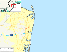
→Route 66 is a state highway located in Monmouth County, New Jersey, United States. It runs 3.62 mi (5.83 km) between Route 33 in Tinton Falls and Route 35 at County Route 16 on the border of Ocean Township and Neptune Township, just to the west of Asbury Park. The route serves as an important connector between the Garden State Parkway to the west and Route 18 and Asbury Park to the east. It runs concurrent with County Route 16 from Brown/Wayside Roads to the eastern terminus at Route 35. Route 66, which varies from a two-lane undivided road to a four-lane divided highway, passes through commercial areas for most of its length with some wooded areas. The route was created in 1953, replacing what had been Route 33-35 Link. There is currently a proposal to widen the two-lane portion between Jumping Brook Road and Wayside Road in order to better handle the traffic that uses this road.
Contents
Route description
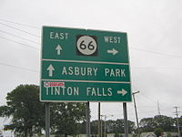
Route 66 begins at an intersection with Route 33 in Tinton Falls, heading to the northeast as a 40 mph (64 km/h) two-lane road. A short distance past Route 33, it comes to an interchange with the Garden State Parkway, where the road becomes a three lane undivided road with one eastbound lane and two westbound lanes.[1] Past this interchange, the route becomes a 50 mph (80 km/h) road that heads into commercial areas, where it widens into a four-lane divided highway that passes by the Jersey Shore Premium Outlets before heading into Neptune Township.[1][2][3] After the intersection with Jumping Brook Road, the divided highway ends and Route 66 becomes a two-lane undivided road.[1] The route heads through a patch of woods before passing more businesses and coming to an intersection with County Route 16 (Asbury Avenue).[1][2] Here, the road becomes a four-lane divided highway again and heads east along the border of Ocean Township to the north and Neptune Township to the south, concurrent with County Route 16.[1] It passes through woodland before coming to a cloverleaf interchange with Route 18. Past Route 18, the road heads into commercial areas again, with the defunct Seaview Square Mall located to the north of the route.[2] Route 66 ends at the Asbury Park Circle with Route 35, where County Route 16 continues east toward Asbury Park on Asbury Avenue.[1][2]
History
Route 66 was legislated in the 1953 New Jersey state highway renumbering to replace what had been Route 33-35 Link.[4] There is a proposal to widen the two-lane portions of Route 66 between Jumping Brook Road and Wayside Road. The need for this widening is due to the need to handle traffic going to Asbury Park in the summer months as well as an evacuation route for the coastal regions of Monmouth County, and the poor design of the current roadway, which lacks turning lanes and facilities for bicycles and pedestrians.[5] In addition, a proposed outlet mall called the Jersey Shore Premium Outlets was planned along the route in Tinton Falls, with improvements planned to the route in the vicinity of the project including an overpass to the outlet mall.[6] In 2006, Neptune Township refused to cooperate with these plans because the original agreement for the outlet mall project in 2001 was no longer up to date with the current traffic demands.[7] Despite this opposition, the plans were approved by the borough of Tinton Falls in 2007 and the Jersey Shore Premium Outlets opened in November 2008.[8][9] As for the widening of Route 66, a meeting was held in August 2009 between members of the 11th state Legislative district and the Commissioner of the New Jersey Department of Transportation.[10]
Major intersections
The entire route is in Monmouth County.
Location Mile[1] Destinations Notes Tinton Falls 0.00  Route 33
Western terminus. 0.24  G.S. Pkwy.
GSP exit 100. Neptune Township 2.51  CR 16 west (Asbury Avenue)
West end of CR 16 overlap. 3.01  Route 18
NJ 18 exit 10. 3.62 
 Route 35 / CR 16 east (Asbury Avenue)
Asbury Park Circle, eastern terminus. 1.000 mi = 1.609 km; 1.000 km = 0.621 mi See also
 U.S. Roads portal
 New Jersey portal
References
- ^ a b c d e f g h "Route 66 straight line diagram" (PDF). New Jersey Department of Transportation. http://www.state.nj.us/transportation/refdata/sldiag/00000066__-.pdf. Retrieved 2009-07-15.
- ^ a b c d Google, Inc. Google Maps – overview of New Jersey Route 66 (Map). Cartography by Google, Inc. http://maps.google.com/maps?f=d&source=s_d&saddr=route+33+and+shark+river+road+tinton+falls,+nj&daddr=Asbury+Ave+%26+Hwy-35+N,+Monmouth,+New+Jersey&geocode=%3BFfnMZQIdH0KW-ynbRReKmCjCiTEO0Na_ACXcNg&hl=en&mra=pe&mrcr=0&sll=40.223189,-74.068623&sspn=0.057933,0.110035&ie=UTF8&ll=40.223582,-74.071712&spn=0.057932,0.110035&t=h&z=13. Retrieved 2009-07-15.
- ^ "Directions & Transportation". Jersey Shore Premium Outlets. http://www.premiumoutlets.com/outlets/directions.asp?id=78. Retrieved 2009-07-15.
- ^ 1953 renumbering. New Jersey Department of Highways. http://en.wikisource.org/wiki/1953_New_Jersey_state_highway_renumbering. Retrieved July 31, 2009.
- ^ "Monmouth County Transportation Council’s 6th Annual Summit". Monmouth County, New Jersey. http://www.visitmonmouth.com/documents%5C24%5CMonmouth%20County%202009%20Projects.pdf. Retrieved 2009-07-15.
- ^ Bowman, Bill and Keith Brown (November 23, 2005). "Outlet Mall Downsizes to Avoid Wetlands". Asbury Park Press. http://www.redorbit.com/news/science/312837/outlet_mall_downsizes_to_avoid_wetlands/. Retrieved 2009-09-07.
- ^ Cangiano, Andrew (January 12, 2006). "Neptune Officials Will Not Cooperate with Mall Plans". The Coaster. http://thecoaster.net/wordpress/2006/01/12/neptune-officials-will-not-cooperate-with-mall-plans/. Retrieved 2009-07-15.
- ^ "Amended final site plan - Development application form" (PDF). Tinton Falls, New Jersey. April 16, 2009. http://www.tintonfalls.com/filestorage/121/673/232/2660/JSPO_AMENDED-REPORTS.pdf. Retrieved 2009-09-07.
- ^ McGeehan, Patrick (November 26, 2008). "Outlets Face Extra Competition This Year, Analysts Say". The New York Times. http://www.nytimes.com/2008/11/30/nyregion/long-island/30Routlook.html?_r=1&scp=6&sq=jersey%20shore%20premium%20outlets&st=cse. Retrieved 2009-09-07.
- ^ Bowman, Bill (August 4, 2009). "Officials to meet next week on Route 66 widening" (Fee required). Asbury Park Press. http://pqasb.pqarchiver.com/app/access/1818043801.html?FMT=ABS&date=Aug+04,+2009. Retrieved 2009-09-07.
External links
Categories:- Transportation in Monmouth County, New Jersey
- State highways in New Jersey
Wikimedia Foundation. 2010.


