- Tinton Falls, New Jersey
-
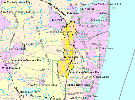
Tinton Falls, New Jersey — Borough — Map of Tinton Falls in Monmouth County. Inset: Location of Monmouth County highlighted in the State of New Jersey.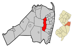 Census Bureau map of Tinton Falls, New Jersey
Coordinates: 40°16′21″N 74°05′20″W / 40.2725°N 74.08889°WCoordinates: 40°16′21″N 74°05′20″W / 40.2725°N 74.08889°W Country United States State New Jersey County Monmouth Incorporated August 15, 1950 as New Shrewsbury Renamed 1975 as Tinton Falls Government[1] – Type Faulkner Act (Mayor-Council) – Mayor Michael Skudera – Administrator Gerald M. Turning, Sr.[2] Area – Total 15.6 sq mi (40.5 km2) – Land 15.6 sq mi (40.4 km2) – Water 0.0 sq mi (0.1 km2) Elevation[3] 118 ft (36 m) Population (2010)[4] – Total 17,892 – Density 1,144.2/sq mi (441.8/km2) Time zone Eastern (EST) (UTC-5) – Summer (DST) EDT (UTC-4) ZIP codes 07700-07799 Area code(s) 732 FIPS code 34-73020[5][6] GNIS feature ID 0885419[7] Website http://www.tintonfalls.com Tinton Falls is a borough in Monmouth County, New Jersey, United States. As of the 2010 United States Census, the borough population was 17,892.[4]
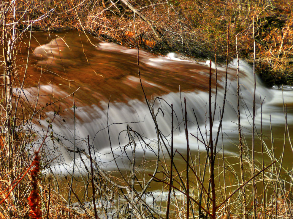
The borough was formed as New Shrewsbury by an act of the New Jersey Legislature on August 15, 1950, based on the results of a referendum held on July 18, 1950, after breaking away from Shrewsbury Township.[8] It was renamed "Tinton Falls" in 1975, to avoid postal errors.[9] The name came from Lewis Morris's plantation, Tinton Manor, which employed free white workers and slaves. The borough is home to the highest waterfall on New Jersey's coastal plain.
Contents
History
The area that is now known as Tinton Falls was originally settled in the late 1600s, probably beginning with the initial land purchases from the Lenni Lenape Indians in 1664.[10] Water power and iron ore were likely the incentives that encouraged settlement: shortly after [the land was purchased], a man by the name of James Grover had an ironworks built along the river. Grover was likely the founder of the community, which, in the 1600s, was named “New Shrewsbury”.[10] At this time, the waterfall was known to be about 30 feet (9.1 m) high;[11][12] erosion and the destruction of the dam near the ironworks have led to its diminishment.
The ironworks
Grover’s ironworks was the central fixture of the community, and it was one of the earliest ironworks built in the country, predated only by buildings in Jamestown and Massachusetts.[10] In 1675, a half-interest in the ironworks company was purchased by Colonel Lewis Morris, [who obtained a title granting him 3,540 acres (14.3 km2) along the Shrewsbury River]. Morris also obtained land owned by Bartholomew Applegate, who had built a corn mill on the other side of the river. Morris, who procured the land for iron mining, named his holdings "Tintern Manor," after his family lands in Monmouthshire, England.[13] Tintern Abbey, located in Monmouthshire, Wales, is often accepted as the namesake of Tinton Falls.[11][12]
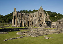 Tintern Abbey in Monmouthshire, Wales, is often accepted as the namesake of Tinton Falls.
In 1691, Colonel Morris died, leaving Tinton Manor (a corruption of “Tintern Manor”) and the ironworks to his nephew of the same name. By 1714, the ironworks had become less profitable, but mention of a Tinton Falls ironworks can be found as late as 1844.
Separation from Shrewsbury Township
In 1693, Tinton Manor and the surrounding lands were defined as part of Shrewsbury Township. At this time, Shrewsbury included all of the land in eastern Monmouth County. Shrewsbury Township became Shrewsbury Borough in 1926, after many of the municipalities in eastern Monmouth County split from the township. In July 1950, Tinton Falls and Wayside left Shrewsbury Borough, renaming themselves the Borough of New Shrewsbury. To avoid postal confusion, the people of the Borough of New Shrewsbury voted to rename the town “The Borough of Tinton Falls” in 1975.[14]
Geography
Tinton Falls is located at 40°16′41″N 74°05′23″W / 40.277953°N 74.089698°W (40.277953, -74.089698).[15]
According to the United States Census Bureau, the borough has a total area of 15.6 square miles (40 km2), of which 0.04 square miles (0.10 km2), or 0.19%, is water.

Middletown Township Red Bank Boro and Twp of
ShrewsburyColts Neck Twp 
Eatontown
Ocean Twp Borough of Tinton Falls

Wall Township Neptune Township Demographics
Historical populations Census Pop. %± 1950 3,783 — 1960 7,313 93.3% 1970 8,395 14.8% 1980 7,740 −7.8% 1990 12,361 59.7% 2000 15,053 21.8% 2010 17,892 18.9% Population 1930 - 1990.[16] As of the census[5] of 2000, there were 15,053 people, 5,883 households, and 3,976 families residing in the borough. The population density was 965.7 people per square mile (372.8/km2). There were 6,211 housing units at an average density of 398.4 per square mile (153.8/km2). The racial makeup of the borough was 78.80% White, 13.04% African American, 0.24% Native American, 4.96% Asian, 0.01% Pacific Islander, 1.04% from other races, and 1.90% from two or more races. Hispanic or Latino of any race were 4.70% of the population.
There were 5,883 households out of which 34.1% had children under the age of 18 living with them, 56.0% were married couples living together, 9.2% had a female householder with no husband present, and 32.4% were non-families. 27.2% of all households were made up of individuals and 7.3% had someone living alone who was 65 years of age or older. The average household size was 2.51 and the average family size was 3.11.
In the borough the population was spread out with 25.5% under the age of 18, 5.2% from 18 to 24, 36.4% from 25 to 44, 22.1% from 45 to 64, and 10.8% who were 65 years of age or older. The median age was 37 years. For every 100 females there were 90.6 males. For every 100 females age 18 and over, there were 86.2 males.
The median income for a household in the borough was $68,697, and the median income for a family was $79,773. Males had a median income of $58,098 versus $37,857 for females. The per capita income for the borough was $31,520. About 2.6% of families and 3.9% of the population were below the poverty line, including 4.3% of those under age 18 and 3.3% of those age 65 or over.
Government
Local government
The Borough of Tinton Falls, since July 1, 1985, has operated under the Mayor-Council form of municipal government under the Faulkner Act.[1]
The Mayor is the Chief Executive Officer of the Borough and is elected for a four-year term. The Borough Business Administrator reports to, and may act for the Mayor, in the Mayor's absence. The Borough Council is the legislative body. There are five members elected at large for four-year terms on a staggered basis, with two or three seats up for election every other year.[17]
As of 2011[update], the mayor of Tinton Falls is Michael Skudera.[18] Members of the Borough Council are Council President Gary Baldwin (2011), Deputy Council President Andrew J. Mayer (2011), Nancyanne Fama (2013), Scott Larkin (2013) and Steven P. Schertz (2011).[19]
Federal, state and county representation
Tinton Falls is in the 12th Congressional district. New Jersey's Twelfth Congressional District is represented by Rush D. Holt, Jr. (D, Hopewell Township).[20] New Jersey is represented in the United States Senate by Frank Lautenberg (D, Cliffside Park) and Bob Menendez (D, Hoboken).
Tinton Falls is in the 12th legislative district of the New Jersey Legislature, which is represented in the New Jersey Senate by Jennifer Beck (R, Red Bank) and in the New Jersey General Assembly by Caroline Casagrande (R, Colts Neck Township) and Declan O'Scanlon (R, Little Silver).[21]
Monmouth County is governed by a Board of Chosen Freeholders consisting of five members who are elected at-large to serve three year terms of office on a staggered basis, with one or two seats up for election each year. [22] As of 2011, Monmouth County's Freeholders are Freeholder Director Robert D. Clifton (R, Matawan; term ends December 31, 2013)[23], Freeholder Deputy Director John P. Curley (R, Red Bank; 2012)[24], Thomas A. Arnone (R, Neptune City; 2013), Lillian G. Burry (R, Colts Neck Township; 2011)[25] and Amy A. Mallet (D, Fair Haven, 2011).[26][27][28]
Education
Public school students in grades K through 8 attend the three schools in the Tinton Falls School District, together with students from the neighboring community of Shrewsbury Township. Schools in the district (with 2008-09 enrollment data from the National Center for Education Statistics[29]) are Mahala F. Atchison School for grades K-3 (740 students), Swimming River School for grades 4&5 (348) and Tinton Falls Middle School grades 6-8 (511). All three district schools are located in Tinton Falls.
In 2004, Mahala F. Atchison School was designated as a Governors School of Excellence, and in 2005 Tinton Falls Middle School earned that designation. Additionally all three schools have won numerous Best Practices awards.
Students in public school for grades 9 to 12 attend Monmouth Regional High School, located in Tinton Falls. The school serves students from Eatontown, Shrewsbury Township and Tinton Falls. Students also come from the military installations of Fort Monmouth and Naval Weapons Station Earle.[30]
Ranney School is a coeducational, nonsectarian K-12 private school founded in 1960, and its campus occupies 60 acres (240,000 m2) off of Hope Road.
Transportation
Passing through Tinton Falls are the Garden State Parkway, Route 18, Route 33, Route 66, Route 35 and Route 36. Tinton Falls houses Exits 100, 102, 105, and 109 on the parkway, including a high-speed toll gate, and the southern start/end of the express and local carriageways.
Major county roads that pass through Tinton Falls are CR 537 and CR 547.
Points of interest
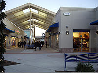 The Jersey Shore Premium Outlets in Tinton Falls opened in 2008
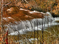 The waterfall of Tinton Falls
- Old Mill at Tinton Falls
- Frozen Ropes, a baseball training center
- Twin Brook Golf Center, a public 9-hole golf course, 18-hole minigolf course, and driving range
- Jersey Shore Premium Outlets, an outdoor shopping mall with 120 outlet stores and a food court
- Tinton Falls Library, one of the branches part of the Monmouth County Library System
- Overlook by the Falls, located near the town's waterfalls (the namesake for the town) and wildlife area.
- Sycamore Recreation Complex, as well as other parks
- The Tinton Police K-9 Unit was established in 1992 by Captain Glenn Rogers and his K9 partner "Rookie". Rookie was retired from active duty in 2000 after distinguishing himself as one of the top police dogs in the state. Currently, the unit consists of three K-9 teams.
Notable residents
Notable current and former residents of Tinton Falls include:
- Alan Garcia (born 1985), thoroughbred horse racing jockey.[31]
- Sean Goldman, 9-year-old boy in the center of an international custody case between his biological father David Goldman and his mother's widower Joao Paulo Lins e Silva. The case was focus of international media coverage and was object of deliberation during meetings of high level Brazilian and American officials.
- Amir Meshal, American who was detained by the Ethiopian military in early 2007 while he was fighting alongside the Union of Islamic Courts militias in Somalia.[32]
- Dorothy Young (1907–2011), entertainer, stage assistant to magician Harry Houdini.[33]
References
- ^ a b 2005 New Jersey Legislative District Data Book, Rutgers University Edward J. Bloustein School of Planning and Public Policy, April 2005, p. 63.
- ^ Administration, Borough of Tinton Falls. Accessed March 30, 2011.
- ^ U.S. Geological Survey Geographic Names Information System: Borough of Tinton Falls, Geographic Names Information System. Accessed January 4, 2008.
- ^ a b "Race, Hispanic or Latino, Age, and Housing Occupancy: 2010 Census Redistricting Data (Public Law 94-171) Summary File (QT-PL), Tinton Falls borough, New Jersey". U.S. Census Bureau, American FactFinder 2. http://factfinder2.census.gov. Retrieved September 1, 2011.
- ^ a b "American FactFinder". United States Census Bureau. http://factfinder.census.gov. Retrieved 2008-01-31.
- ^ A Cure for the Common Codes: New Jersey, Missouri Census Data Center. Accessed July 14, 2008.
- ^ "US Board on Geographic Names". United States Geological Survey. 2007-10-25. http://geonames.usgs.gov. Retrieved 2008-01-31.
- ^ "The Story of New Jersey's Civil Boundaries: 1606-1968", John P. Snyder, Bureau of Geology and Topography; Trenton, New Jersey; 1969. p. 183.
- ^ If You're Thinking of Living In/Tinton Falls, N.J.; An Old Area That Has Bloomed Lately, The New York Times, July 22, 2001.
- ^ a b c James S. Brown (1976). William A. Barrett. ed. Historical Scrapbook of Tinton Falls, New Jersey. The Tinton Falls Bicentennial Committee. pp. 5–9. http://www.tintonfalls.com/filestorage/121/673/267/TFHistory.pdf.
- ^ a b Harry B. Weiss and Howard R. Kemble (1976). Historical Scrapbook of Tinton Falls, New Jersey. The Tinton Falls Bicentennial Committee. pp. 31–36. http://www.tintonfalls.com/filestorage/121/673/267/TFHistory.pdf.
- ^ a b Randall Gabrielan (1999). The American Century Series: Tinton Falls in the Twentieth Century. Arcadia.
- ^ William A. Barrett, ed (1976). Historical Scrapbook of Tinton Falls, New Jersey. The Tinton Falls Bicentennial Committee. http://www.tintonfalls.com/filestorage/121/673/267/TFHistory.pdf.
- ^ Edmund Constantini (1998). Know Your Town: Tinton Falls. The League of Women Voters, Greater Red Bank Area.
- ^ "US Gazetteer files: 2010, 2000, and 1990". United States Census Bureau. 2011-02-12. http://www.census.gov/geo/www/gazetteer/gazette.html. Retrieved 2011-04-23.
- ^ New Jersey Resident Population by Municipality: 1930 - 1990, Workforce New Jersey Public Information Network. Accessed March 1, 2007.
- ^ Government Overview Tinton Falls Government, Borough of Tinton Falls. Accessed November 12, 2008.
- ^ Mayor's Welcome, Borough of Tinton Falls. Accessed March 30, 2011.
- ^ Borough Council Members, Borough of Tinton Falls. Accessed March 30, 2011.
- ^ Municipalities, Congressman Rush D. Holt, Jr. Accessed June 29, 2008.
- ^ "Legislative Roster: 2010-2011 Session". New Jersey Legislature. http://www.njleg.state.nj.us/members/roster.asp. Retrieved 2010-02-08.
- ^ Monmouth County Government, Monmouth County, New Jersey. Accessed January 5, 2011.
- ^ Freeholder Director Robert D. Clifton, Monmouth County, New Jersey. Accessed January 7, 2011.
- ^ Deputy Director Freeholder John P. Curley, Monmouth County, New Jersey. Accessed January 7, 2011.
- ^ Freeholder Lillian G. Burry, Monmouth County, New Jersey. Accessed January 7, 2011.
- ^ Freeholder Amy A. Mallet, Monmouth County, New Jersey. Accessed January 7, 2011.
- ^ Board of Chosen Freeholders, Monmouth County, New Jersey. Accessed January 7, 2011.
- ^ Rizzo, Nina. "Monmouth County freeholders sworn into office", Asbury Park Press, January 6, 2011. Accessed January 7, 2011.
- ^ Data for the Tinton Falls School District, National Center for Education Statistics. Accessed March 31, 2011.
- ^ Monmouth Regional High School 2010 Report card Narrative, New Jersey Department of Education. Accessed March 21, 2011. "Pupils who attend this school reside in the Monmouth County communities of Eatontown, Shrewsbury Township and Tinton Falls. In addition, students come from the military facilities of Fort Monmouth and Earle Naval Weapons Station."
- ^ Alan Garcia, Breeders Cup. Accessed November 12, 2008.
- ^ Linzer, Dafna. "U.S. Presses for Release of American Held in Ethiopia", The Washington Post, March 23, 2007. Accessed June 29, 2008. "Amir Meshal, 24, of Tinton Falls, N.J., was among dozens of people picked up by the Kenyan military on Jan. 12 as they fled a U.S-backed Ethiopian invasion into neighboring Somalia."
- ^ Brown, Emma. "Dorothy Young, Houdini’s stage partner, dies at 103", The Washington Post, March 25, 2011. Accessed March 30, 2011. "Dorothy Young, a petite dancer who was the last surviving person to share a stage with escape artist and magician Harry Houdini, died March 20 at 103 at her home in Tinton Falls, N.J. The cause of death was not reported."
External links
- Borough of Tinton Falls official website
- Tinton Falls School District
- Tinton Falls School District's 2009–10 School Report Card from the New Jersey Department of Education
- Data for the Tinton Falls School District, National Center for Education Statistics
- Monmouth Regional High School District
 State of New Jersey
Topics Regions - Atlantic Coastal Plain
- Central Jersey
- Delaware River Region
- Delaware Valley
- Gateway Region
- Gold Coast
- Highlands
- Jersey Shore
- Meadowlands
- New York metro area
- North Hudson
- North Jersey
- Pascack Valley
- Piedmont
- Pine Barrens
- Raritan Bayshore
- Ridge-and-Valley Appalachians
- Southern Shore Region
- Skylands Region
- South Jersey
- Tri‑State Region
- West Hudson
Counties Major cities Categories:- Boroughs in Monmouth County, New Jersey
- Faulkner Act Mayor-Council


Wikimedia Foundation. 2010.