- Shrewsbury, New Jersey
Infobox Settlement
official_name = Shrewsbury, New Jersey
settlement_type = Borough
nickname =
motto =
imagesize =
image_caption =
image_
imagesize =
image_caption =
image_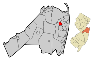
mapsize = 250x200px
map_caption = Map of Shrewsbury in Monmouth County. Inset: Location of Monmouth County highlighted in the State of New Jersey.
mapsize1 = 250x200px
map_caption1 = Census Bureau map of Shrewsbury, New Jerseysubdivision_type = Country
subdivision_name =United States
subdivision_type1 = State
subdivision_name1 =New Jersey
subdivision_type2 = County
subdivision_name2 = Monmouth
government_footnotes =
government_type =Borough (New Jersey)
leader_title =Mayor
leader_name = Emilia M. Siciliano
leader_title1 =
leader_name1 =
established_title = Incorporated
established_date =May 11 ,1926 unit_pref = Imperial
area_footnotes =
area_magnitude =
area_total_km2 = 5.8
area_land_km2 = 5.7
area_water_km2 = 0.0
area_total_sq_mi = 2.2
area_land_sq_mi = 2.2
area_water_sq_mi = 0.0population_as_of = 2006
population_footnotes =
population_total = 3717
population_density_km2 = 628.2
population_density_sq_mi = 1627.1timezone = Eastern (EST)
utc_offset = -5
timezone_DST = EDT
utc_offset_DST = -4
elevation_footnotes = [Gnis|885395|Borough of Shrewsbury,Geographic Names Information System . AccessedJanuary 4 ,2008 .]
elevation_m = 10
elevation_ft = 33
latd = 40 |latm = 19 |lats = 36 |latNS = N
longd = 74 |longm = 03 |longs = 34 |longEW = Wpostal_code_type =
ZIP code
postal_code = 07702
area_code = 732
blank_name = FIPS code
blank_info = 34-67350GR|2 [ [http://mcdc2.missouri.edu/webrepts/commoncodes/ccc_nj.html A Cure for the Common Codes: New Jersey] , Missouri Census Data Center. AccessedJuly 14 ,2008 .]
blank1_name = GNIS feature ID
blank1_info = 0885395GR|3
website = http://www.shrewsburyboro.com
footnotes =Shrewsbury is a Borough in Monmouth County,
New Jersey ,United States . As of theUnited States 2000 Census , the borough population was 3,590.Shrewsbury was formed as a borough by an Act of the
New Jersey Legislature onMarch 22 ,1926 , from portions of Shrewsbury Township), based on the results of a referendum held onMay 11 ,1926 ."The Story of New Jersey's Civil Boundaries: 1606-1968", John P. Snyder, Bureau of Geology and Topography; Trenton, New Jersey; 1969. p. 185.]Shrewsbury was the birthplace of explorer and writer
John Lloyd Stephens .Geography
Shrewsbury is located at coor dms|40|19|35|N|74|3|33|W|city (40.326524, -74.059289)GR|1.
According to the
United States Census Bureau , the borough has a total area of 2.2square mile s (5.7km² ), of which, 2.2 square miles (5.7 km²) of it is land and 0.04 square miles (0.1 km²) of it (0.90%) is water.Shrewsbury was once a much larger township, encompassing several of the other municipalities nearby.
Demographics
USCensusPop
1930=857
1940=1058
1950=1613
1960=3222
1970=3315
1980=2962
1990=3096
2000=3590
estimate= 3717
estyear=2006
estref= [http://factfinder.census.gov/servlet/SAFFPopulation?_event=ChangeGeoContext&geo_id=16000US3467350&_geoContext=01000US%7C04000US34%7C16000US3470110&_street=&_county=shrewsbury&_cityTown=shrewsbury&_state=04000US34&_zip=&_lang=en&_sse=on&ActiveGeoDiv=geoSelect&_useEV=&pctxt=fph&pgsl=010&_submenuId=population_0&ds_name=null&_ci_nbr=null&qr_name=null®=null%3Anull&_keyword=&_industry= Census data for Shrewsbury borough] ,United States Census Bureau . AccessedAugust 9 ,2007 .]
footnote=Population 1930 - 1990. [ [http://www.wnjpin.net/OneStopCareerCenter/LaborMarketInformation/lmi01/poptrd6.htm New Jersey Resident Population by Municipality: 1930 - 1990] , Workforce New Jersey Public Information Network. AccessedMarch 1 ,2007 .] As of thecensus GR|2 of 2000, there were 3,590 people, 1,207 households, and 1,016 families residing in the borough. Thepopulation density was 1,627.1 people per square mile (627.2/km²). There were 1,223 housing units at an average density of 554.3/sq mi (213.7/km²). The racial makeup of the borough was 96.60% White, 0.53% African American, 1.67% Asian, 0.36% from other races, and 0.84% from two or more races. Hispanic or Latino of any race were 1.92% of the population.There were 1,207 households out of which 46.0% had children under the age of 18 living with them, 74.6% were married couples living together, 7.2% had a female householder with no husband present, and 15.8% were non-families. 12.9% of all households were made up of individuals and 6.9% had someone living alone who was 65 years of age or older. The average household size was 2.96 and the average family size was 3.27.
In the borough the population was spread out with 30.8% under the age of 18, 4.0% from 18 to 24, 28.1% from 25 to 44, 25.1% from 45 to 64, and 12.0% who were 65 years of age or older. The median age was 38 years. For every 100 females there were 98.5 males. For every 100 females age 18 and over, there were 93.2 males.
The median income for a household in the borough was $86,911, and the median income for a family was $92,719. Males had a median income of $85,875 versus $37,554 for females. The
per capita income for the borough was $38,218. None of the families and 1.0% of the population were living below thepoverty line , including no under 18 and 3.0% of those over 64.Government
Local government
Shrewsbury is governed under the Borough form of New Jersey municipal government. The government consists of a Mayor and a Borough Council comprising six council members, with all positions elected at large. A Mayor is elected directly by the voters to a four-year term of office. The Borough Council consists of six members elected to serve three-year terms on a staggered basis, with two seats coming up for election each year. ["2005 New Jersey Legislative District Data Book",
Rutgers University Edward J. Bloustein School of Planning and Public Policy , April 2005, p. 63.]The current mayor of Shrewsbury is Emilia M. Siciliano. Members of the Shrewsbury Borough Council are Council President Terel J. Cooperhouse, Donald W. Burden, Marlene Hotaling, John J. McGuire, Thomas Menapace and Kevin Murphy. [ [http://www.shrewsburyboro.com/mc.html Shrewsbury Borough Mayor and Council] , Shrewsbury Borough. Accessed
May 22 ,2007 .]Federal, state and county representation
Shrewsbury is in the Twelfth Congressional District and is part of New Jersey's 12th Legislative District. [ [http://www.lwvnj.org/pubs/CG06.pdf 2006 New Jersey Citizen's Guide to Government] , New Jersey
League of Women Voters , p. 64. AccessedAugust 30 ,2006 .]Education
The
Shrewsbury Borough School District serves public school students ranging from pre-school to 8th grade. The Shrewbury Borough School had an enrollment of 513 students in the 2005-06 school year. [ [http://nces.ed.gov/ccd/schoolsearch/school_list.asp?Search=1&DistrictID=3414970 Data for the Shrewsbury Borough School District] ,National Center for Education Statistics . AccessedJune 4 ,2008 .] The current superintendent is Lawrence Ambrosino, who will be retiring in 2008. This school features three homerooms per grade. There are special classes that include physical education, art, music, computers, and for language, Spanish.For grades 9-12, public school students attend
Red Bank Regional High School , which serves students from the boroughs of Little Silver, Red Bank and Shrewsbury. [ [http://education.state.nj.us/rc/rc07/narrative/25/4365/25-4365-050.html Red Bank Regional High School 2007 Report Card Narrative] ,New Jersey Department of Education . AccessedJune 3 ,2008 . "Red Bank Regional High School is a comprehensive secondary school that offers a wide array of academic and extra-curricular program offerings for the student body which numbers 1,200. The constituent sending districts include Little Silver, Red Bank Borough and Shrewsbury, but many people from other towns still go there."]Students also may attend Christian Brothers Academy or
Red Bank Catholic High School , the localCatholic school s, or one of the five vocational schools represented by Monmouth County (ie. High Technology High School).Notable residents
Notable current and former residents of Shrewsbury include:
*E. C. Hazard (1831-1905), major 19th- and early 20th-century foodimporter ,manufacturer , and distributor.
*Michael J. Panter (1969-), who represented the 12th legislative district in theNew Jersey General Assembly from 2006 to 2008. [ [http://votesmart.org/bio.php?can_id=43172 Assembly Member Michael J. 'Mike' Panter] ,Project Vote Smart . AccessedAugust 9 ,2007 .]
*John Lloyd Stephens (1805-1852), explorer, writer, and diplomat, who was a pivotal figure in the rediscovery ofMaya civilization throughout Middle America and in the planning of thePanama railway . [ [http://www.nyslittree.org/index.cfm/fuseaction/DB.PersonDetail/PersonPK/550.cfm Person Detail: John Lloyd Stephens] , New York State Literary Tree. AccessedDecember 4 ,2007 .]References
External links
* [http://www.shrewsburyboro.com/ Shrewsbury Borough website]
* [http://www.sbs.k12.nj.us/ Shrewsbury Borough School]
*NJReportCard|25|4770|050|Shrewsbury Borough School District
* [http://nces.ed.gov/ccd/schoolsearch/school_list.asp?Search=1&DistrictID=3414970 Data for the Shrewsbury Borough School District] ,National Center for Education Statistics
* [http://www.redbankregional.k12.nj.us/ Red Bank Regional High School]
*NJReportCard|25|4365|050|Red Bank Regional High School
* [http://nces.ed.gov/ccd/schoolsearch/school_list.asp?Search=1&DistrictID=3413750 Data for the Red Bank Regional High School] ,National Center for Education Statistics
Wikimedia Foundation. 2010.