- Oceanport, New Jersey
-
Oceanport, New Jersey — Borough — Map of Oceanport in Monmouth County. Inset: Location of Monmouth County highlighted in the State of New Jersey.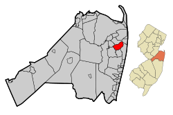 Census Bureau map of Oceanport, New Jersey
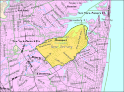
Coordinates: 40°18′54″N 74°01′11″W / 40.315°N 74.01972°WCoordinates: 40°18′54″N 74°01′11″W / 40.315°N 74.01972°W Country United States State New Jersey County Monmouth Incorporated May 11, 1920 Government[1] – Type Borough (New Jersey) – Mayor Michael J. Mahon Area – Total 3.9 sq mi (10.0 km2) – Land 3.2 sq mi (8.3 km2) – Water 0.6 sq mi (1.6 km2) Elevation[2] 20 ft (6 m) Population (2010)[3] – Total 5,832 – Density 1,510.5/sq mi (583.2/km2) Time zone Eastern (EST) (UTC-5) – Summer (DST) EDT (UTC-4) ZIP code 07757 Area code(s) 732 FIPS code 34-54570[4][5] GNIS feature ID 0885334[6] Website http://oceanportboro.com Oceanport is a borough in Monmouth County, New Jersey, United States. As of the 2010 United States Census, the borough population was 5,832.[3]
Oceanport was formed as a borough by an act of the New Jersey Legislature on April 6, 1920, from portions of Eatontown Township (now Eatontown), based on the results of a referendum held on May 11, 1920.[7]
New Jersey Monthly magazine ranked Oceanport as its 4th best place to live in its 2008 rankings of the "Best Places To Live" in New Jersey.[8]
Contents
Geography
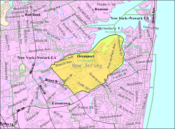
Oceanport is located at 40°19′01″N 74°00′56″W / 40.317010°N 74.015632°W (40.317010, -74.015632).[9]
According to the United States Census Bureau, the borough has a total area of 3.9 square miles (10 km2), of which 3.2 square miles (8.3 km2) is land and 0.6 square miles (1.6 km2), or 16.32%, is water.
Oceanport borders Little Silver to the northwest, Long Branch to the east, Eatontown to the southwest, and West Long Branch to the southeast. It also shares a water border to the northeast with Monmouth Beach and forms a peninsula, jutting into the Shrewsbury River.
Demographics
Historical populations Census Pop. %± 1930 1,872 — 1940 3,159 68.8% 1950 7,588 140.2% 1960 4,937 −34.9% 1970 7,503 52.0% 1980 5,888 −21.5% 1990 6,146 4.4% 2000 5,807 −5.5% 2010 5,832 0.4% Population 1930 - 1990.[10] As of the census[4] of 2000, there were 5,807 people, 2,043 households, and 1,554 families residing in the borough. The population density was 1,802.1 people per square mile (696.3/km2). There were 2,114 housing units at an average density of 656.0 per square mile (253.5/km2). The racial makeup of the borough was 95.71% White, 1.96% African American, 0.07% Native American, 0.79% Asian, 0.02% Pacific Islander, 0.55% from other races, and 0.90% from two or more races. Hispanic or Latino of any race were 2.07% of the population.
There were 2,043 households out of which 35.2% had children under the age of 18 living with them, 66.0% were married couples living together, 8.4% had a female householder with no husband present, and 23.9% were non-families. 21.7% of all households were made up of individuals and 10.7% had someone living alone who was 65 years of age or older. The average household size was 2.71 and the average family size was 3.18.
In the borough the population was spread out with 24.5% under the age of 18, 8.4% from 18 to 24, 25.5% from 25 to 44, 27.4% from 45 to 64, and 14.2% who were 65 years of age or older. The median age was 40 years. For every 100 females there were 98.1 males. For every 100 females age 18 and over, there were 96.0 males.
The median income for a household in the borough was $71,458, and the median income for a family was $85,038. Males had a median income of $57,955 versus $39,718 for females. The per capita income for the borough was $33,356. About 1.8% of families and 2.7% of the population were below the poverty line, including 2.1% of those under age 18 and 3.5% of those age 65 or over.
Port-au-peck
Oceanport can be separated into two sections. One is called Oceanport and the other Port-au-peck (a main road through the town is Port-au-peck Avenue). Although both range from middle class to upper-middle class, Port-au-peck is more heavily residential and has many more high-end homes. There are several reasons for this. One is that it is a complete peninsula jutting into the Shrewsbury River. Because of this it has many more elegant waterfront homes. It is also very close to the communities of Little Silver, Fair Haven, Long Branch, Monmouth Beach, and Rumson. These towns and Port-au-peck form the boundaries of the Shrewsbury River. The Oceanport side houses some senior citizens. Monmouth Park Racetrack, Fort Monmouth, and a border with the borough of Eatontown are also within Oceanport. The New Jersey Transit train line which runs in front of Monmouth Park is the common separator to divide the two sections.
Mailing address
Presently, almost all residents use an Oceanport mailing address. This is encouraged by the borough as it has only one post office, which is under the name Oceanport and has one ZIP Code (07757). In the past, however (1920s-1970s), many citizens would use Port-au-peck as a mailing address because to people who knew the area, it sounded more high end and was considered more wealthy. They would still, however, use the same zip code of 07757.
Phone numbers
Residents of Oceanport use area code 732 and can use area code 908 for cell phones. Most home phone numbers start with 222, 229, and 571 on the Port-au-peck side and 544 or 542 on the Oceanport side.
Government
Local government
Oceanport is governed under the Borough form of New Jersey municipal government. The government consists of a Mayor and a Borough Council comprising six council members, with all positions elected at large. A Mayor is elected directly by the voters to a four-year term of office. The Borough Council consists of six members elected to serve three-year terms on a staggered basis, with two seats coming up for election each year.[1]
As of 2011[update], the Mayor of Oceanport Borough is Michael J. Mahon.[11] Members of the Borough Council are Council President Richard Gallo (term ends December 31, 2011), Jerry Bertekap (2012), John W. Ibex (2013), Joseph A. Irace (2013), William Johnson (2012) and Ellynn M. Kahle (2011).[12]
Oceanport is a participating municipality in an initiative to study regionalizing their municipal police force with one or more municipalities. The borough received a grant from the New Jersey Department of Community Affairs in the amount of $40,950 along with the Boroughs of Fair Haven, Little Silver, Shrewsbury and Rumson to hire professional consultants to conduct the study on their behalf. A report was due before the end of 2007.[citation needed]
Federal, state and county representation
Oceanport is in the 12th Congressional district. New Jersey's Twelfth Congressional District is represented by Rush D. Holt, Jr. (D, Hopewell Township).[13] New Jersey is represented in the United States Senate by Frank Lautenberg (D, Cliffside Park) and Bob Menendez (D, Hoboken).
Oceanport is in the 12th legislative district of the New Jersey Legislature, which is represented in the New Jersey Senate by Jennifer Beck (R, Red Bank) and in the New Jersey General Assembly by Caroline Casagrande (R, Colts Neck Township) and Declan O'Scanlon (R, Little Silver).[14]
Monmouth County is governed by a Board of Chosen Freeholders consisting of five members who are elected at-large to serve three year terms of office on a staggered basis, with one or two seats up for election each year. [15] As of 2011, Monmouth County's Freeholders are Freeholder Director Robert D. Clifton (R, Matawan; term ends December 31, 2013)[16], Freeholder Deputy Director John P. Curley (R, Red Bank; 2012)[17], Thomas A. Arnone (R, Neptune City; 2013), Lillian G. Burry (R, Colts Neck Township; 2011)[18] and Amy A. Mallet (D, Fair Haven, 2011).[19][20][21]
Education
Students in Kindergarten through eighth grade in public school are educated by the Oceanport School District, which also serves students from Sea Bright as part of a sending/receiving relationship.[22] Schools in the district (with 2005-06 enrollment data from the National Center for Education Statistics[23]) are Wolf Hill Elementary School, with 361 students in Kindergarten through 4th grade; and Maple Place Middle School, with 312 students in grades 5 - 8.
For grades 9 - 12, public school students attend Shore Regional High School, a regional high school that serves students from the constituent districts of Monmouth Beach, Sea Bright, Oceanport and West Long Branch.[24] The high school is part of the Shore Regional High School District.
Monmouth Park
The famed Monmouth Park, a thoroughbred horse race track, is home to the annual Haskell Invitational Handicap. The choice to put the track in this small community in 1946 was made because of its prime location at the shore. Oceanport is also an easy getaway for New Yorkers and North Jersey folk who make up the majority of the track crowd. The Haskell, which next to the Triple Crown is horse racing's biggest event, takes place each year in August. In October 2007, Oceanport's Monmouth Park hosted the multi-day Breeders' Cup. Monmouth Park has been repeatedly fined by the New Jersey Department of Environmental Protection for polluting the Branchport Creek section of the Shrewsbury River.[citation needed]
Transportation
Route 71 and County Route 33 pass through Oceanport.
New Jersey Transit's North Jersey Coast Line has a nearby limited-service stop at the Monmouth Park station for Monmouth Park Racetrack.
NJ Transit local bus service is provided on the 831 route.[25]
Notable people
Notable current and former residents of Oceanport include:
- Phil Bredesen (born 1943), Governor of Tennessee.[26]
- Charles J. O'Byrne (born 1959), top aide to Governor of New York David Paterson.[27]
- Kevin Smith (born 1970), filmmaker, lived in Oceanport in the 1990s.[28]
References
- ^ a b 2005 New Jersey Legislative District Data Book, Rutgers University Edward J. Bloustein School of Planning and Public Policy, April 2005, p. 63.
- ^ U.S. Geological Survey Geographic Names Information System: Borough of Oceanport, Geographic Names Information System. Accessed June 13, 2008.
- ^ a b "Race, Hispanic or Latino, Age, and Housing Occupancy: 2010 Census Redistricting Data (Public Law 94-171) Summary File (QT-PL), Oceanport borough, New Jersey". U.S. Census Bureau, American FactFinder 2. http://factfinder2.census.gov. Retrieved September 1, 2011.
- ^ a b "American FactFinder". United States Census Bureau. http://factfinder.census.gov. Retrieved 2008-01-31.
- ^ A Cure for the Common Codes: New Jersey, Missouri Census Data Center. Accessed July 14, 2008.
- ^ "US Board on Geographic Names". United States Geological Survey. 2007-10-25. http://geonames.usgs.gov. Retrieved 2008-01-31.
- ^ "The Story of New Jersey's Civil Boundaries: 1606-1968", John P. Snyder, Bureau of Geology and Topography; Trenton, New Jersey; 1969. p. 184.
- ^ "Best Places To Live - The Complete Top Towns List 1-100", New Jersey Monthly, February 21, 2008. Accessed February 24, 2008.
- ^ "US Gazetteer files: 2010, 2000, and 1990". United States Census Bureau. 2011-02-12. http://www.census.gov/geo/www/gazetteer/gazette.html. Retrieved 2011-04-23.
- ^ New Jersey Resident Population by Municipality: 1930 - 1990, Workforce New Jersey Public Information Network. Accessed March 1, 2007.
- ^ A Message from Our Mayor, Borough of Oceanport. Accessed June 22, 2011.
- ^ Our Council, Borough of Oceanport. Accessed June 22, 2011. Nore that a 2010 term-end date is listed for Irace as of the date accessed.
- ^ Municipalities, Congressman Rush D. Holt, Jr. Accessed June 29, 2008.
- ^ "Legislative Roster: 2010-2011 Session". New Jersey Legislature. http://www.njleg.state.nj.us/members/roster.asp. Retrieved 2010-02-08.
- ^ Monmouth County Government, Monmouth County, New Jersey. Accessed January 5, 2011.
- ^ Freeholder Director Robert D. Clifton, Monmouth County, New Jersey. Accessed January 7, 2011.
- ^ Deputy Director Freeholder John P. Curley, Monmouth County, New Jersey. Accessed January 7, 2011.
- ^ Freeholder Lillian G. Burry, Monmouth County, New Jersey. Accessed January 7, 2011.
- ^ Freeholder Amy A. Mallet, Monmouth County, New Jersey. Accessed January 7, 2011.
- ^ Board of Chosen Freeholders, Monmouth County, New Jersey. Accessed January 7, 2011.
- ^ Rizzo, Nina. "Monmouth County freeholders sworn into office", Asbury Park Press, January 6, 2011. Accessed January 7, 2011.
- ^ Oceanport Board of Education, Oceanport School District. Accessed June 19, 2008. " One of the unique aspects of Oceanport Schools is that Oceanport receives students from Sea Bright on a tuition basis. Therefore a member of the Sea Bright Board of Education sits on the Oceanport Board of Education, making the total of the board to 10."
- ^ Data for the Oceanport School District, National Center for Education Statistics. Accessed February 14, 2008.
- ^ Shore Regional High School 2007 School Report Card Narrative, New Jersey Department of Education. Accessed February 14, 2008. "Shore Regional High School is a comprehensive secondary school that proudly serves the communities of Monmouth Beach, Oceanport, Sea Bright, and West Long Branch."
- ^ Monmouth Somerset County Bus/Rail Connections, New Jersey Transit. Accessed July 15, 2007.
- ^ Campaign 2004 Candidate Profile: Philip Bredesen, USA Today. Accessed November 27, 2007.
- ^ Horowitz, Jason. "Gov. Paterson's Main Man: Former Jesuit, 'Natural' Politician Charles O'Byrne", The New York Observer, March 15, 2008. Accessed April 3, 2008. "Mr. O'Byrne, 48, spent his first years in Manhattan and Staten Island before moving to Oceanport in New Jersey at the age of five. He attended Red Bank high School, off the Navesink River on the Jersey Shore, and after graduating in 1977, he attended Columbia University, earning his degree in 1981."
- ^ Staff. "Kevin Smith, the sequel", Asbury Park Press, July 18, 1999. Accessed June 22, 2011. "Born at 4:57 p.m., Harley Quinn weighed 7 pounds and 8 ounces and will reside with her parents in their new home in Oceanport."
External links
- Borough of Oceanport official website
- Oceanport School District
- Oceanport School District's 2009–10 School Report Card from the New Jersey Department of Education
- Data for the Oceanport School District, National Center for Education Statistics
- Shore Regional High School
 State of New Jersey
Topics Regions - Atlantic Coastal Plain
- Central Jersey
- Delaware River Region
- Delaware Valley
- Gateway Region
- Gold Coast
- Highlands
- Jersey Shore
- Meadowlands
- New York metro area
- North Hudson
- North Jersey
- Pascack Valley
- Piedmont
- Pine Barrens
- Raritan Bayshore
- Ridge-and-Valley Appalachians
- Southern Shore Region
- Skylands Region
- South Jersey
- Tri‑State Region
- West Hudson
Counties Major cities Categories:- Boroughs in Monmouth County, New Jersey


Wikimedia Foundation. 2010.