- Eatontown, New Jersey
Infobox Settlement
official_name = Eatontown, New Jersey
settlement_type = Borough
nickname =
motto =
imagesize =
image_caption =
image_
imagesize =
image_caption =
image_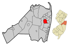
mapsize = 250x200px
map_caption = Map of Eatontown in Monmouth County. Inset: Location of Monmouth County highlighted in the State of New Jersey.
mapsize1 = 250x200px
map_caption1 = Census Bureau map of Eatontown, New Jerseysubdivision_type = Country
subdivision_name =United States
subdivision_type1 = State
subdivision_name1 =New Jersey
subdivision_type2 = County
subdivision_name2 = Monmouth
government_footnotes =
government_type =Borough (New Jersey)
leader_title =Mayor
leader_name = Gerald J. Tarantolo (2010)
leader_title1 = Administrator
leader_name1 = George Jackson
established_title = Incorporated
established_date =April 4 ,1873 unit_pref = Imperial
area_footnotes =
area_magnitude =
area_total_km2 = 15.3
area_land_km2 = 15.3
area_water_km2 = 0.0
area_total_sq_mi = 5.9
area_land_sq_mi = 5.9
area_water_sq_mi = 0.0population_as_of = 2006
population_footnotes =
population_total = 14022
population_density_km2 = 913.8
population_density_sq_mi = 2366.8timezone = Eastern (EST)
utc_offset = -5
timezone_DST = EDT
utc_offset_DST = -4
elevation_footnotes = [Gnis|885202|Borough of Eatontown,Geographic Names Information System . AccessedJanuary 4 ,2008 .]
elevation_m = 17
elevation_ft = 56
latd = 40 |latm = 17 |lats = 29 |latNS = N
longd = 74 |longm = 03 |longs = 18 |longEW = Wpostal_code_type =
ZIP code s
postal_code = 07724, 07799
area_code = 732
blank_name = FIPS code
blank_info = 34-19840GR|2 [ [http://mcdc2.missouri.edu/webrepts/commoncodes/ccc_nj.html A Cure for the Common Codes: New Jersey] , Missouri Census Data Center. AccessedJuly 14 ,2008 .]
blank1_name = GNIS feature ID
blank1_info = 0885202GR|3
website = http://www.eatontownnj.com
footnotes =Eatontown is a Borough in Monmouth County,
New Jersey ,United States . As of theUnited States 2000 Census , the borough population was 14,008.What is now Eatontown was originally incorporated as Eatontown Township by an Act of the
New Jersey Legislature onApril 4 ,1873 , from portions of Ocean Township and Shrewsbury Township. Portions of the township were taken to form West Long Branch (April 7 ,1908 ) and Oceanport (April 6 ,1920 ). Eatontown was reincorporated as a borough onMarch 8 ,1926 , replacing Eatontown Township, based on the results of a referendum held onApril 13 ,1926 ."The Story of New Jersey's Civil Boundaries: 1606-1968", John P. Snyder, Bureau of Geology and Topography; Trenton, New Jersey; 1969. p. 179.]The
United States Army 'sFort Monmouth has been in Eatontown since 1917, and is home to theU.S. Army Materiel Command 's (AMC) Communication and Electronics Command (CECOM). Fort Monmouth is also home to theUnited States Military Academy Preparatory School (or USMAPS), which trains approximately 250 students per year to enter as freshmen (plebes) at theUnited States Military Academy at West Point. [ [http://www.usma.edu/USMAPS/ Welcome to West Point Prep] ,United States Military Academy Preparatory School . AccessedAugust 4 ,2008 .]In the center of Eatontown is the
Monmouth Mall , located at the intersection of Route 35 and Route 36. Monmouth Mall has a variety of stores, restaurants, and a 15-screen cineplex.Geography
Eatontown is located at coor dms|40|17|37|N|74|3|24|W|city (40.293571, -74.056715)GR|1.
According to the
United States Census Bureau , the borough has a total area of 5.9square mile s (15.4km² ), of which, 5.9 square miles (15.3 km²) of it is land and 0.17% is water.Demographics
USCensusPop
1930=1938
1940=1758
1950=3044
1960=10334
1970=14619
1980=12703
1990=13800
2000=14008
estimate= 14022
estyear=2006
estref= [http://factfinder.census.gov/servlet/SAFFPopulation?_event=Search&geo_id=16000US3416660&_geoContext=01000US%7C04000US34%7C16000US3416660&_street=&_county=eatontown&_cityTown=eatontown&_state=04000US34&_zip=&_lang=en&_sse=on&ActiveGeoDiv=geoSelect&_useEV=&pctxt=fph&pgsl=160&_submenuId=population_0&ds_name=null&_ci_nbr=null&qr_name=null®=null%3Anull&_keyword=&_industry= Census data for Eatontown borough] ,United States Census Bureau , accessedMarch 1 ,2007 ]
footnote=Population 1930 - 1990. [ [http://www.wnjpin.net/OneStopCareerCenter/LaborMarketInformation/lmi01/poptrd6.htm New Jersey Resident Population by Municipality: 1930 - 1990] , Workforce New Jersey Public Information Network. AccessedMarch 1 ,2007 .] As of thecensus GR|2 of 2000, there were 14,008 people, 5,780 households, and 3,444 families residing in the borough. Thepopulation density was 2,366.8 people per square mile (913.6/km²). There were 6,341 housing units at an average density of 1,071.4/sq mi (413.6/km²). The racial makeup of the borough was 73.29% White, 11.61% African American, 0.34% Native American, 9.32% Asian, 0.04% Pacific Islander, 2.31% from other races, and 3.10% from two or more races. Hispanic or Latino of any race were 6.62% of the population.There were 5,780 households out of which 28.7% had children under the age of 18 living with them, 46.8% were married couples living together, 9.9% had a female householder with no husband present, and 40.4% were non-families. 33.8% of all households were made up of individuals and 10.0% had someone living alone who was 65 years of age or older. The average household size was 2.35 and the average family size was 3.08.
In the borough the population was spread out with 22.9% under the age of 18, 7.0% from 18 to 24, 35.0% from 25 to 44, 21.7% from 45 to 64, and 13.3% who were 65 years of age or older. The median age was 37 years. For every 100 females there were 94.7 males. For every 100 females age 18 and over, there were 91.2 males.
The median income for a household in the borough was $53,833, and the median income for a family was $69,397. Males had a median income of $49,508 versus $35,109 for females. The
per capita income for the borough was $26,965. About 3.5% of families and 5.7% of the population were below thepoverty line , including 4.3% of those under age 18 and 9.2% of those age 65 or over.Government
Local government
Eatontown is governed under the Borough form of New Jersey municipal government. The government consists of a Mayor and a Borough Council comprising six council members, with all positions elected at large. A Mayor is elected directly by the voters to a four-year term of office. The Borough Council consists of six members elected to serve three-year terms on a staggered basis, with two seats coming up for election each year."2005 New Jersey Legislative District Data Book",
Rutgers University Edward J. Bloustein School of Planning and Public Policy , April 2005, p. 58.]The
Mayor of Eatontown is [http://eatontownnj.com/government/gov.asp?gov_id=2 Gerald J. Tarantolo] (term endsDecember 31 ,2010 ). Members of the Borough Council are Council President [http://eatontownnj.com/government/gov.asp?gov_id=5 Charles E. DaVis] , [http://eatontownnj.com/government/gov.asp?gov_id=14 Theresa Forbes] , [http://eatontownnj.com/government/gov.asp?gov_id=6 Gerri Hopkins] , [http://eatontownnj.com/government/gov.asp?gov_id=12 Victoria Rau] , [http://eatontownnj.com/government/gov.asp?gov_id=13 John Schiels] and [http://eatontownnj.com/government/gov.asp?gov_id=7 Carl Sohl] . [http://eatontownnj.com/government/gov.asp?gov_id=15 Mayor and Council] , Eatontown Borough. AccessedApril 23 ,2008 .]Federal, state and county representation
Eatontown is in the Twelfth Congressional District and is part of New Jersey's 11th Legislative District. [ [http://www.lwvnj.org/pubs/CG06.pdf 2006 New Jersey Citizen's Guide to Government] , New Jersey
League of Women Voters , p. 56. AccessedAugust 30 ,2006 .]Education
Students in grades K through 8 attend the
Eatontown Public Schools . Schools in the district (with 2005-06 enrollment data from theNational Center for Education Statistics [ [http://nces.ed.gov/ccd/schoolsearch/school_list.asp?Search=1&DistrictID=3404410 Data for Eatontown Public Schools] ,National Center for Education Statistics . AccessedApril 23 ,2008 .] ) are three K-6 elementary schools — [http://www.etnps.org/schools/meadowbrook/ Meadowbrook Elementary School] (308 students), [http://www.etnps.org/schools/vetter Margaret L. Vetter Elementary School] (312) and [http://www.etnps.org/schools/woodmere Woodmere Elementary School] (266) — and [http://www.etnps.org/schools/memorial Memorial Middle School] for grades 7 and 8 (276).Public school students in grades 9 to 12 attend
Monmouth Regional High School , located in Tinton Falls. The high school is part of theMonmouth Regional High School District , which serves students from Shrewsbury Township and Tinton Falls, along with students from Eatontown,Fort Monmouth andNaval Weapons Station Earle . [ [http://education.state.nj.us/rc/rc06/narrative/25/3270/25-3270-050.html Monmouth Regional High School 2006 Report card Narrative] ,New Jersey Department of Education . AccessedApril 23 ,2008 . "Pupils attending reside in the Monmouth County communities of Eatontown, Shrewsbury Township and Tinton Falls. In addition, some students come from the military facilities of Fort Monmouth and Earle Naval Weapons Station."]Notable residents
*
Liati Mayk (1981-)singer-songwriter , visualartist ,poet and athlete. [Kaplan, Ron. [http://www.njjewishnews.com/njjn.com/080907/moEatontownNativesPower.html "Eatontown natives power Israel to surprising success in softball"] , "New Jersey Jewish News ",August 7 ,2007 . AccessedDecember 28 ,2007 . "Eatontown native and star softball player Shyella Mayk, 28, and her sister Liati, 25, are part of the Israeli squad, which finished in a surprising fourth place at last month's European B Pool Championships held in Zagreb, Croatia."]References
External links
* [http://www.eatontownnj.com Eatontown website]
* [http://www.eatontown.org/ Eatontown Public Schools]
*NJReportCard|25|1260|0|Eatontown Public Schools
* [http://nces.ed.gov/ccd/schoolsearch/school_list.asp?Search=1&DistrictID=3404410 Data for Eatontown Public Schools] ,National Center for Education Statistics
* [http://www.monmouthregional.net Monmouth Regional High School District]
Wikimedia Foundation. 2010.