- Cliffwood Beach, New Jersey
-
Cliffwood Beach, New Jersey — CDP — Map of Cliffwood Beach in Monmouth County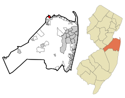
Coordinates: 40°26′29″N 74°13′3″W / 40.44139°N 74.2175°WCoordinates: 40°26′29″N 74°13′3″W / 40.44139°N 74.2175°W Country United States State New Jersey County Monmouth[1] Area - Total 1.0 sq mi (2.5 km2) - Land 0.9 sq mi (2.4 km2) - Water 0.0 sq mi (0.1 km2) Elevation 56 ft (17 m) Population (2010) - Total 3,194 - Density 3,309/sq mi (1,277.6/km2) Time zone Eastern (EST) (UTC-5) - Summer (DST) EDT (UTC-4) ZIP code 07735 Area code(s) 732 FIPS code 34-13630[2] GNIS feature ID 0875498[3] Cliffwood Beach is a census-designated place (CDP) in Monmouth County, New Jersey, United States. The population was 3,194 as of the 2010 census.[4]
Contents
Geography
Cliffwood Beach is part of Aberdeen Township in Monmouth County. It is located north of Route 35 and is bounded by Keyport on the east and Laurence Harbor on the west. The community faces Raritan Bay, including a portion of Keyport Harbor, and Matawan Creek separates Cliffwood Beach from Keyport. To the west, a section of Cliffwood Beach is part of Old Bridge Township in neighboring Middlesex County. The counties are separated by Whale Creek, which is spanned near the bayfront by a concrete bridge.
According to the United States Census Bureau, the CDP has a total area of 2.5 km2 (0.9 mi2). 2.4 km2 (0.9 mi2) of it is land and 0.1 km2 (0.04 mi2) of it (2.11%) is water. Cliffwood Beach is located at 40°26′29″N 74°13′03″W / 40.441478°N 74.217448°W (40.441478, -74.217448).[5]
Education
Monmouth County side of Cliffwood Beach is home to Cliffwood Elementary School, one of seven schools in the Matawan-Aberdeen Regional School District. Those students who reside in the Monmouth County side of Cliffwood Beach attend Lloyd Road Pre-Middle School (Grades 4-5), then Matawan Aberdeen Middle School, and finally Matawan Regional High School.
Demographics
Historical populations Census Pop. %± 1990 3,543 — 2000 3,538 −0.1% source: [6] As of the census[2] of 2000, there were 3,538 people, 1,149 households, and 881 families residing in the CDP. The population density was 1,468.8/km2 (3,809.2/mi2). There were 1,178 housing units at an average density of 489.1/km2 (1,268.3/mi2). The racial makeup of the CDP was 78.60% White, 15.04% African American, 0.31% Native American, 1.36% Asian, 2.88% from other races, and 1.81% from two or more races. Hispanic or Latino of any race were 9.78% of the population.
There were 1,149 households out of which 38.1% had children under the age of 18 living with them, 57.2% were married couples living together, 14.1% had a female householder with no husband present, and 23.3% were non-families. 16.4% of all households were made up of individuals and 4.9% had someone living alone who was 65 years of age or older. The average household size was 2.99 and the average family size was 3.37.
In the CDP the population was spread out with 26.5% under the age of 18, 7.5% from 18 to 24, 33.7% from 25 to 44, 22.5% from 45 to 64, and 9.8% who were 65 years of age or older. The median age was 36 years. For every 100 females there were 98.3 males. For every 100 females age 18 and over, there were 94.2 males.
The median income for a household in the CDP was $57,098, and the median income for a family was $61,875. Males had a median income of $44,856 versus $32,714 for females. The per capita income for the CDP was $22,874. About 5.0% of families and 5.5% of the population were below the poverty line, including 7.2% of those under age 18 and 6.5% of those age 65 or over.
History
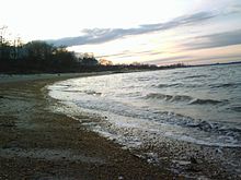 Cliffwood Beach at sunset, looking towards South Amboy
Cliffwood Beach was a popular resort in the 1950s and early 1960s, with a boardwalk, saltwater swimming pool, dining and dancing at The Cat n Fiddle, and other amusements. The beachfront facilities were destroyed by Hurricane Donna in September 1960. All that remains is the swimming pool, though it is currently buried in a sand dune that helps support part of the sea wall. The top of the pool walls, including the top wall of the "four foot" section ("4 ft" is still visible in black paint) can still be viewed if one is willing to walk through the foliage that conceals the buried pool from plain sight.
A "Cliffwood Beach" directional sign is seen briefly in the 1939 documentary The City (with music by Aaron Copland). An unending traffic jam getting to the beach is used in the film as an endemic problem of unplanned growth.
Cliffwood Beach was an early recipient of aid through the New Jersey Department of Environmental Protection's Green Acres Program [1], which was established in 1961. The township received funds to build a park near the Cliffwood Beach waterfront. The tennis courts have since been converted to an enclosed in-line skating arena, and the original playground equipment and two basketball courts have been upgraded.
It was featured in Weird NJ magazine's Issue #28. The article, "Cliffwood Beach: A Forgotten Resort", recounted the abrupt manner in which the town was forgotten.[7]
Nothing remains for any of the boardwalk amusements, except for the large swimming pool, which lies abandoned and filled with debris.[8]
The beachfront is currently slated for redevelopment, and has been for years. Many of the residents, however, doubt the local government will actually do anything because little has been done over the years to actually help improve the area.[9]
References
- ^ "Detailed map of New Jersey" (PDF). United States Census Bureau. 2000. http://www2.census.gov/geo/maps/general_ref/cousub_outline/cen2k_pgsz/nj_cosub.pdf. Retrieved 2010-11-16.
- ^ a b "American FactFinder". United States Census Bureau. http://factfinder.census.gov. Retrieved 2008-01-31.
- ^ "US Board on Geographic Names". United States Geological Survey. 2007-10-25. http://geonames.usgs.gov. Retrieved 2008-01-31.
- ^ "Race, Hispanic or Latino, Age, and Housing Occupancy: 2010 Census Redistricting Data (Public Law 94-171) Summary File (QT-PL), Cliffwood Beach CDP, New Jersey". U.S. Census Bureau, American FactFinder 2. http://factfinder2.census.gov. Retrieved September 2, 2011.
- ^ "US Gazetteer files: 2010, 2000, and 1990". United States Census Bureau. 2011-02-12. http://www.census.gov/geo/www/gazetteer/gazette.html. Retrieved 2011-04-23.
- ^ "Population Finder: Cliffwood Beach CDP, New Jersey". U.S. Census Bureau. http://factfinder.census.gov/servlet/SAFFPopulation?_event=Search&geo_id=06000US3402500070&_geoContext=01000US%7C04000US34%7C05000US34025%7C06000US3402500070&_street=&_county=cliffwood&_cityTown=cliffwood&_state=&_zip=&_lang=en&_sse=on&ActiveGeoDiv=geoSelect&_useEV=&pctxt=fph&pgsl=060&_submenuId=population_0&ds_name=null&_ci_nbr=null&qr_name=null®=null%3Anull&_keyword=&_industry=. Retrieved 2007-03-18.
- ^ "Cliffwood Beach: A Forgotten Resort", Weird NJ magazine, Issue #28
- ^ YouTube - Horrorflicks:(2) Matawan Shark Attack {Part 1}
- ^ Bowes, Karen E. "Turning the tide at Cliffwood Beach: Aberdeen hopes to upgrade and beautify beachfront, seawall", Holmdel Independent, September 26, 2007. Accessed September 29, 2007.
Categories:- Census-designated places in New Jersey
- Old Bridge Township, New Jersey
- Populated places in Monmouth County, New Jersey
- Raritan Bayshore


Wikimedia Foundation. 2010.