- Laurence Harbor, New Jersey
Infobox Settlement
official_name = Laurence Harbor, New Jersey
settlement_type = CDP
nickname =
motto =
imagesize =
image_caption =
image_
imagesize =
image_caption =
image_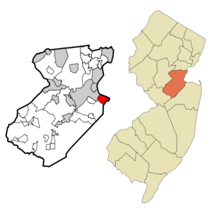
mapsize = 250x200px
map_caption = Map of Laurence Harbor CDP in Middlesex County
mapsize1 =
map_caption1 =subdivision_type = Country
subdivision_name =United States
subdivision_type1 = State
subdivision_name1 =New Jersey
subdivision_type2 = County
subdivision_name2 = Middlesex
government_footnotes =
government_type =
leader_title =
leader_name =
leader_title1 =
leader_name1 =
established_title =
established_date =area_footnotes =
area_magnitude =
area_total_km2 = 7.5
area_land_km2 = 7.3
area_water_km2 = 0.2
area_total_sq_mi = 2.9
area_land_sq_mi = 2.8
area_water_sq_mi = 0.1population_as_of = 2000
population_footnotes =
population_total = 6227
population_density_km2 = 853.4
population_density_sq_mi = 2210.3timezone = Eastern (EST)
utc_offset = -5
timezone_DST = EDT
utc_offset_DST = -4
elevation_footnotes =
elevation_m = 8
elevation_ft = 26
latd = 40 |latm = 27 |lats = 3 |latNS = N
longd = 74 |longm = 14 |longs = 44 |longEW = Wpostal_code_type =
ZIP code s
postal_code = 08878-08879
area_code = 732
blank_name = FIPS code
blank_info = 34-39360GR|2
blank1_name = GNIS feature ID
blank1_info = 0877695GR|3
website =
footnotes =Laurence Harbor is a
census-designated place and unincorporated area located on theRaritan Bay within Old Bridge Township, in Middlesex County,New Jersey . As of theUnited States 2000 Census , the CDP population was 6,227.Geography
. The railroad, which has no station in Laurence Harbor, divides the town into eastern and western sections, the former being locally referred to as 'The Front'.
The shore looks directly upon
Staten Island 's southern shore; theVerrazano-Narrows Bridge ,Lower Manhattan , andBrooklyn can also be seen.Cheslow, [http://query.nytimes.com/gst/fullpage.html?res=9902E2D61030F935A15751C1A9629C8B63&sec=&spon=&pagewanted=all " LIVING IN/Laurence Harbor, N.J.; An Old Haunt Re-emerges on Raritan Bay"] , "The New York Times ",December 26 ,2004 . AccessedMay 15 ,2007 . "A two-square-mile enclave in Old Bridge Township, Laurence Harbor comprises mainly compact two- and three-bedroom winterized bungalows built in the 20's and 30's on 25- or 50-by-100-foot lots, and is one of the most affordable neighborhoods in New Jersey's booming Middlesex County.... Laurence Harbor is named for Laurence Lamb, a turn-of-the-20th-century entrepreneur who established a 400-acre shorefront golf and country club on the site."]According to the
United States Census Bureau , the CDP has a total area of 7.5km² (2.9 mi²). 7.3 km² (2.8 mi²) of it is land and 0.2 km² (0.1 mi²) of it (2.08%) is water.Morgan
One mile northwest, across the
Cheesequake Creek and the Morgan Bridge is Morgan. Named after the 1703 family and the cousins of the infamous Pirate CaptainHenry Morgan . This family had 645 acres here.History
that was much larger than it is today. In 1869, Madison Township split off from South Amboy, becoming Old Bridge Township in 1975.
European settlement of the area was linked to commerce passing through the nearby Amboys along the
Raritan River . From a military perspective, the area was useful for it high bayside cliffs, which allowed for strategic observation of ships traveling betweenNew York Harbor and theAtlantic Ocean .Laurence Harbor is named after land developer Laurence Lamb, who bought property in then-Madison Township at the turn of the 20th century and subdivided it into bungalow-sized lots. For those traveling south from
North Jersey or New York, it was the first stretch ofJersey Shore beachfront before the more popular Keansburg or Asbury Park.Demographics
USCensusPop
1990=6361
2000=6227
footnote=source: [cite web |url=http://factfinder.census.gov/servlet/SAFFPopulation?_event=Search&geo_id=16000US3408492&_geoContext=01000US%7C04000US34%7C16000US3408492&_street=&_county=laurence+harbor&_cityTown=laurence+harbor&_state=04000US34&_zip=&_lang=en&_sse=on&ActiveGeoDiv=geoSelect&_useEV=&pctxt=fph&pgsl=160&_submenuId=population_0&ds_name=null&_ci_nbr=null&qr_name=null®=null%3Anull&_keyword=&_industry=
title=Population Finder: Laurence Harbor CDP, New Jersey
publisher=U.S. Census Bureau
accessdate=2007-03-18] As of thecensus GR|2 of 2000, there were 6,227 people, 2,286 households, and 1,634 families residing in the CDP. Thepopulation density was 852.6/km² (2,210.3/mi²). There were 2,362 housing units at an average density of 323.4/km² (838.4/mi²). The racial makeup of the CDP was 90.65% White, 3.57% African American, 0.22% Native American, 2.20% Asian, 0.05% Pacific Islander, 1.64% from other races, and 1.67% from two or more races. Hispanic or Latino of any race were 6.86% of the population.There were 2,286 households out of which 34.4% had children under the age of 18 living with them, 55.6% were married couples living together, 11.5% had a female householder with no husband present, and 28.5% were non-families. 22.7% of all households were made up of individuals and 4.9% had someone living alone who was 65 years of age or older. The average household size was 2.72 and the average family size was 3.25.
In the CDP the population was spread out with 25.6% under the age of 18, 7.4% from 18 to 24, 34.9% from 25 to 44, 24.5% from 45 to 64, and 7.5% who were 65 years of age or older. The median age was 36 years. For every 100 females there were 104.0 males. For every 100 females age 18 and over, there were 100.1 males.
The median income for a household in the CDP was $57,997, and the median income for a family was $61,470. Males had a median income of $46,439 versus $30,918 for females. The
per capita income for the CDP was $23,619. About 4.3% of families and 5.6% of the population were below thepoverty line , including 7.2% of those under age 18 and 10.8% of those age 65 or over.Economy
Housing
Real estate in Laurence Harbor is inexpensive when compared to anywhere else around it in all three directions. It was often considered a bit underclass because of its high working class and retiree population. In the 1990s Bridgepointe, a 400-unit upscale townhouse community, was constructed at the western end of Laurence Harbor near Exit 120 of the Garden State Parkway.
Parks and recreation
Laurence Harbor is home to Old Bridge Waterfront Park and adjacent to
Cheesequake State Park , which are both popular sites for fishing. Deer are seen in the state park, even from the parkway.Environment
Deforestation
There is hardly any old growth trees in all of the Jersey Shore, because it was used for lumber and fuel. Especially Laurence Harbor, a section of land that grows up to about 70' above sea level at its peak. Surrounded by the marshes on its other three sides. For this reason, it was an easy source of wood which fueled many nearby brick yards and the once very famous clay sources and kilns nearby in Morgan/Sayreville for the pottery market. Industry and population growth weighed very heavily on the trees in the area and it is very hard to find an old red, scarlet, pin oaks and Sycamores even reaching 70 years. Laurence Harbor may have a few reaching only 9'-11' circumference by comparison. Belvedere also has an old white oak known as The Shoe Tree, reportedly well over 200 years old. Many species die after 120 years so it is eventual that some do reach maturity. But many will never return to their multi-century potential that graced the coast a few hundred years ago.
Pollution
Pollution began in the area early. Water quality on the nearby marshes were already being damaged before the 1940s war era. The water table and health concerns only first became an issue in the early 1970s, a little late, but a beginning nonetheless. Water during the 1950s coming out of the tap was tinted orange and had a very heavy iron taste possibly copper. The petrochemical and paint industry were just miles away. The United States Government had an armory nearby and is responsible for tons of munitions waste nearby.
World War I andWorld War II residue was dumped at the mouth of theRaritan River in Perth/South Amboy.References
External links
Wikimedia Foundation. 2010.