- Aberdeen Township, New Jersey
-
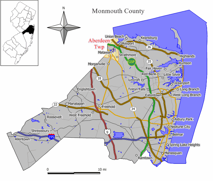
Aberdeen Township, New Jersey — Township — Map of Aberdeen Township in Monmouth County. Inset: Location of Monmouth County highlighted in the State of New Jersey.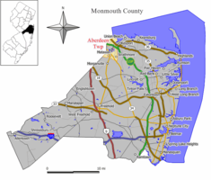 Census Bureau map of Aberdeen Township, New Jersey
Coordinates: 40°25′2″N 74°13′22″W / 40.41722°N 74.22278°WCoordinates: 40°25′2″N 74°13′22″W / 40.41722°N 74.22278°W Country United States State New Jersey County Monmouth Incorporated February 23, 1857 as Matavan Township Renamed 1882 as Matawan Township Renamed November 8, 1977 as Aberdeen Township Government[1] – Type Faulkner Act (Council-Manager) – Mayor Fred Tagliarini – Manager Holly Reycraft Area – Total 7.8 sq mi (20.1 km2) – Land 5.5 sq mi (14.3 km2) – Water 2.2 sq mi (5.7 km2) Elevation 52 ft (16 m) Population (2010)[2] – Total 18,210 – Density 3,152.2/sq mi (1,217.1/km2) Time zone Eastern (EST) (UTC-5) – Summer (DST) EDT (UTC-4) ZIP code 07747 Area code(s) 732 FIPS code 34-00070[3][4] GNIS feature ID 0882121[5] Website http://www.aberdeennj.org/ Aberdeen Township is a Township in Monmouth County, New Jersey, United States. As of the 2010 United States Census, the township population was 18,210.[2]
Aberdeen Township is part of the Bayshore Regional Strategic Plan, an effort by nine municipalities in northern Monmouth County to reinvigorate the area's economy by emphasizing the traditional downtowns, dense residential neighborhoods, maritime history, and the natural beauty of the Raritan Bay coastline.
Contents
Geography
According to the United States Census Bureau, the township has a total area of 7.8 square miles (20 km2), of which, 5.5 square miles (14 km2) of it is land and 2.2 square miles (5.7 km2) of it (28.61%) is water.
Cliffwood Beach (2000 Census population of 3,538) and Strathmore (6,740) are census-designated places and unincorporated areas located within Aberdeen Township
Demographics
Historical populations Census Pop. %± 1930 2,496 — 1940 2,633 5.5% 1950 3,888 47.7% 1960 7,359 89.3% 1970 17,680 140.3% 1980 17,235 −2.5% 1990 17,038 −1.1% 2000 17,454 2.4% Est. 18,210 4.3% Population 1930 - 1990.[6][2] As of the census[3] of 2000, there were 17,454 people, 6,421 households, and 4,770 families residing in the township. The population density was 3,152.2 people per square mile (1,216.4/km²). There were 6,558 housing units at an average density of 1,184.4 per square mile (457.1/km²). The racial makeup of the township was 78.82% White, 12.02% African American, 0.14% Native American, 5.51% Asian, 0.01% Pacific Islander, 1.75% from other races, and 1.75% from two or more races. Hispanic or Latino of any race were 7.02% of the population.
There were 6,421 households out of which 34.4% had children under the age of 18 living with them, 60.2% were married couples living together, 10.5% had a female householder with no husband present, and 25.7% were non-families. 20.2% of all households were made up of individuals and 5.0% had someone living alone who was 65 years of age or older. The average household size was 2.70 and the average family size was 3.14.
In the township the population was spread out with 24.5% under the age of 18, 6.2% from 18 to 24, 35.0% from 25 to 44, 24.0% from 45 to 64, and 10.4% who were 65 years of age or older. The median age was 37 years. For every 100 females there were 95.1 males. For every 100 females age 18 and over, there were 92.4 males.
The median income for a household in the township was $68,125, and the median income for a family was $76,648. Males had a median income of $51,649 versus $35,707 for females. The per capita income for the township was $28,984. About 3.8% of families and 4.7% of the population were below the poverty line, including 7.1% of those under age 18 and 4.6% of those age 65 or over.
Government
Local government
On November 3, 1964, the citizens of Aberdeen Township voted to change from the Township Committee form of government, in force since 1857, to the Council-Manager form, under the Faulkner Act. In this Council-Manager form, all policy making power is concentrated in the council. The Mayor is a member of the Council and presides over its meetings. The Manager, appointed by the council and fully accountable to it, is the municipal chief executive and administrative official. Aberdeen Township is one of over 40 municipalities in New Jersey with this form of government.
A seven-member Township Council is elected at large for staggered, four-year terms of office in partisan elections held in November.[1] The council selects a mayor and deputy mayor from among its members.
As of 2011[update], members of the Aberdeen Township Council are Mayor Fred Tagliarini, Deputy Mayor Vincent Vinci, Greg Cannon, Owen Drapkin, Wilhelmina Gumbs and James Lauro and Margaret Montone.[7]
Federal, state and county representation
Aberdeen Township is in the 6th Congressional district and is part of New Jersey's 13th state legislative district.[8] The legislative district was unchanged based on the results of the 2010 Census.[2]
New Jersey's Sixth Congressional District is represented by Frank Pallone (D, Long Branch). New Jersey is represented in the United States Senate by Frank Lautenberg (D, Cliffside Park) and Bob Menendez (D, Hoboken).
13th district of the New Jersey Legislature, which is represented in the New Jersey Senate by Joseph M. Kyrillos (R, Middletown Township) and in the New Jersey General Assembly by Amy Handlin (R, Middletown Township) and Samuel D. Thompson (R, Old Bridge Township).[9] The Governor of New Jersey is Chris Christie (R, Mendham).[10] The Lieutenant Governor of New Jersey is Kim Guadagno (R, Monmouth Beach).[11]
Monmouth County is governed by a Board of Chosen Freeholders consisting of five members who are elected at-large to serve three year terms of office on a staggered basis, with one or two seats up for election each year. [12] As of 2011, Monmouth County's Freeholders are Freeholder Director Robert D. Clifton (R, Matawan; term ends December 31, 2013)[13], Freeholder Deputy Director John P. Curley (R, Red Bank; 2012)[14], Thomas A. Arnone (R, Neptune City; 2013), Lillian G. Burry (R, Colts Neck Township; 2011)[15] and Amy A. Mallet (D, Fair Haven, 2011).[16][17][18]
Education
Aberdeen is part of the Matawan-Aberdeen Regional School District, together with the neighboring community of Matawan. Schools in the district (with 2005-06 enrollment data from the National Center for Education Statistics[19]) are Cambridge Park Developmental Learning Center (Preschool; 55 students), Cliffwood Elementary School (Grades K-3; 431 students), Ravine Drive Elementary School (Grades K-3; 351 students), Strathmore Elementary School (Grades K-3; 472 students), Lloyd Road Elementary School (Grades 4-5; 603 students), Matawan Aberdeen Middle School (Grades 6 - 8; 926 students) and Matawan Regional High School (Grades 9 - 12; 1,052 students). The MARSD Central Offices are located at 1 Crest Way, in Aberdeen.
History
Origins
Those who settled in this area developed into the Lenni Lenape Native Americans. About the year 1000, an agricultural society developed, and small villages dotted what was to become New Jersey. The Lenape began a westward retreat in the face of European settlement and disease beginning in the late seventeenth century, beginning in Monmouth County by the mid-eighteenth century. Although the Lenape presently live in Ontario and Oklahoma, their legacy survives in such names as Mohingson, Luppatatong and Matawan Creeks and Raritan Bay.
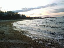 Cliffwood Beach, located in Aberdeen, New Jersey, was a popular resort until Hurricane Donna destroyed its boardwalk.
The earliest known attempt at European settlement was in 1650 when the south side of Raritan Bay was purchased from the Lenni Lenape by the New Netherland Colony. The Dutch failed to make any permanent settlements of this area.
New Jersey
The earliest English land grant in Aberdeen was in 1677 when Sir George Carteret granted 36 acres (146,000 m²) to Jonathan Holmes. This is in present-day Oakshades on Mohingson Creek.
Aberdeen Township derived its name from "New Aberdeen," a name for a settlement established in Northwestern Monmouth County in the 1680s by Quakers and Presbyterians who fled Scotland to avoid religious persecution.
In 1684, Surveyor General Thomas Rudyard received a grant of 1,038 acres (4.20 km2) on Raritan Bay and Matawan Creek, the present location of Cliffwood and Cliffwood Beach. Owing to Rudyard's high office, this was quite controversial, and in 1685, the Board of Proprietors issued an order regarding the laying out of land. Section 7 addressed questionable activity such as Rudyard's, and he sold his land to his son-in-law, Samuel Winder.
The 1680s saw an influx of Scottish immigrants fleeing religious persecution in response to a 1683 book by George Scott extolling the virtues of Scottish settlement in East Jersey. In 1701, a village site of 100 acres (405,000 m²) was granted by the Proprietors to 24 Scottish settlers of the area. These men and six others also purchased a landing site on Matawan Creek.
The village site eventually came to be called Mount Pleasant, and the landing, as it became an important shipping point for the produce of Middletown Township, became Middletown Point. A third, very scattered settlement developed in the eighteenth century west of Matawan Creek, and was called Matawan or Matavan.
Middletown Township
Since 1693, what was to become Aberdeen Township remained part of Middletown Township which, at the time, consisted of what is now Aberdeen, Holmdel Township, Hazlet Township, Middletown (including Sandy Hook), Matawan Borough, Keyport, Union Beach, Keansburg, Atlantic Highlands, Highlands and a sliver of Colts Neck Township. It originally extended as far northwest as Cheesequake Creek, that portion being ceded to Middlesex County in 1710.
Raritan Township
By 1848, Middletown was considered too large and unwieldy, and legislation was passed dividing it into two halves, the western half to be a new municipality, Raritan Township (now Hazlet Township).
Matawan Township
Legislation sponsored by Assemblyman Beers passed the State Assembly and Senate, was signed by Governor of New Jersey William A. Newell, and on February 23, 1857, Matavan Township was incorporated from portions of what was then Raritan Township.[20] This included the village of Middletown Point, Mt. Pleasant, and Matavan. The Township was named for the creek as well as the village of Matavan. The spelling of "Matawan" or "Matavan" had been interchangeable, however, when the act was published "Matavan", a Lenape word meaning "where two rivers come together" had been used.
In 1865, due to postal confusion with Middletown, the Middletown Point post office was renamed "Matawan", to reflect the name of the Township. This section is the present downtown area of Matawan Borough. In 1882, the spelling of the Township was officially changed to "Matawan".[20]
When the railroads were built in the 1870s several stations were established. As the station at Main Street was to be "Matawan", the one at Cliffwood Avenue had to be something else, although the old name "Matavan" was still applied to that area. To avoid near duplication, "Hutschler's Crossing" was briefly used; the railroad then changed the station name to "Cliffwood", after the coastal area of the Township.
Cliffwood Post Office
In 1885, the Cliffwood post office was established and the name of the old Matavan settlement passed into obsolescence. That same year, the former Middletown Point section, which had adopted the name "Matawan", was incorporated by referendum as the Borough of Matawan. Originally a self-governing district within the Township, the Borough gained full municipality status in 1896.
Freneau Post Office
In response to demand, a post office was established at Mount Pleasant in 1889. As that name was in use elsewhere, a new name was needed. "Freneau" was chosen, in honor of Philip Morin Freneau, the "Poet of Revolution," and a former Mount Pleasant resident who is buried in the area. This post office has since been closed.
Matawan Borough
Matawan was formed as a borough on June 28, 1895, from portions of Matawan Township, based on the results of a referendum held that day. Matawan expanded with portions of Matawan Township in 1931 and 1933.[20]
Cliffwood Beach
The twentieth century saw several major developments in the Township. The 1920s gave us Cliffwood Beach, which was originally a resort community until after World War II when year-round homes were the norm. River Gardens developed in the late 1940s, and the 1960s brought Strathmore, which more than doubles the Township's population and transformed a farming community into a bustling suburb.
Aberdeen Township
On November 8, 1977, the residents of Matawan Township voted to change the name of the Township to create a community identity separate from that of Matawan Borough. The residents voted to call their community Aberdeen Township.[21] Officials believed the new name would draw attention to the Township, as it is listed first alphabetically among New Jersey's 566 municipalities.
Today, Aberdeen is a suburban Township of 5.4 square miles (14 km2) containing a mix of residence, light industry and shopping centers. Sections of the Township include Cliffwood, Cliffwood Beach, Freneau, Oakshades, River Gardens, Strathmore and Woodfield. The population is approximately 17,000 and there are three postal ZIP codes which service the Township: 07721, 07735 and 07747.
The Township is served by two volunteer fire companies, the Aberdeen Township Hose and Chemical Co. No. 1, organized in 1918, and the Cliffwood Volunteer Fire Co., organized in 1927. Two volunteer First Aid Squads response to the community's emergency medical needs; the Aberdeen Township First Aid and Rescue Squad, organized in 1954, and the South Aberdeen Emergency Medical Service, organized in 1970. A Full time Police Department was established in 1935.
The Henry Hudson Trail is a 9-mile (14 km) paved trail built on a former Central Railroad of New Jersey right-of-way and extending from Aberdeen Township east to Atlantic Highlands.
Notable residents
Notable residents of Aberdeen Township include:
- David L. Smith, creator of the Melissa worm first identified in March 1999.[22] Smith was sentenced in 2002 to serve 20 months in a federal prison.[23]
References
- ^ a b 2005 New Jersey Legislative District Data Book, Rutgers University Edward J. Bloustein School of Planning and Public Policy, April 2005, p. 67.
- ^ a b c d 2011 Apportionment Redistricting: Municipalities sorted alphabetically, New Jersey Department of State. Accessed June 2, 2011.
- ^ a b "American FactFinder". United States Census Bureau. http://factfinder.census.gov. Retrieved 2008-01-31.
- ^ A Cure for the Common Codes: New Jersey, Missouri Census Data Center. Accessed July 14, 2008.
- ^ "US Board on Geographic Names". United States Geological Survey. 2007-10-25. http://geonames.usgs.gov. Retrieved 2008-01-31.
- ^ New Jersey Resident Population by Municipality: 1930 - 1990, Workforce New Jersey Public Information Network. Accessed March 1, 2007.
- ^ Telephone and eMail Directory, Aberdeen Township. Accessed June 2, 2011.
- ^ 2011 New Jersey Citizen's Guide to Government, New Jersey League of Women Voters, p. 54. Accessed June 2, 2011.
- ^ "Legislative Roster: 2010-2011 Session". New Jersey Legislature. http://www.njleg.state.nj.us/members/roster.asp. Retrieved 2010-02-08.
- ^ "About the Governor". New Jersey. http://www.nj.gov/governor/about/. Retrieved 2010-01-21.
- ^ "About the Lieutenant Governor". New Jersey. http://www.nj.gov/governor/lt/. Retrieved 2010-01-21.
- ^ Monmouth County Government, Monmouth County, New Jersey. Accessed January 5, 2011.
- ^ Freeholder Director Robert D. Clifton, Monmouth County, New Jersey. Accessed January 7, 2011.
- ^ Deputy Director Freeholder John P. Curley, Monmouth County, New Jersey. Accessed January 7, 2011.
- ^ Freeholder Lillian G. Burry, Monmouth County, New Jersey. Accessed January 7, 2011.
- ^ Freeholder Amy A. Mallet, Monmouth County, New Jersey. Accessed January 7, 2011.
- ^ Board of Chosen Freeholders, Monmouth County, New Jersey. Accessed January 7, 2011.
- ^ Rizzo, Nina. "Monmouth County freeholders sworn into office", Asbury Park Press, January 6, 2011. Accessed January 7, 2011.
- ^ Data for the Matawan-Aberdeen Regional School District, National Center for Education Statistics. Accessed July 14, 2008.
- ^ a b c "The Story of New Jersey's Civil Boundaries: 1606-1968", John P. Snyder, Bureau of Geology and Topography; Trenton, New Jersey; 1969. p. 182.
- ^ "Aberdeen Told to Vote On Changing Address", The New York Times, June 13, 1978. p. NJ23.
- ^ Creator of "Melissa" Computer Virus Pleads Guilty to State and Federal Charges, United States Department of Justice press release dated December 9, 1999.
- ^ Creator of Melissa Computer Virus Sentenced to 20 Months in Federal Prison, United States Department of Justice press release dated May 1, 2002.
External links
- Aberdeen Township website
- Matawan-Aberdeen Regional School District
- Matawan-Aberdeen Regional School District's 2009–10 School Report Card from the New Jersey Department of Education
- Young Israel of Aberdeen
- Data for the Matawan-Aberdeen Regional School District, National Center for Education Statistics
 State of New Jersey
Topics Regions - Atlantic Coastal Plain
- Central Jersey
- Delaware River Region
- Delaware Valley
- Gateway Region
- Gold Coast
- Highlands
- Jersey Shore
- Meadowlands
- New York metro area
- North Hudson
- North Jersey
- Pascack Valley
- Piedmont
- Pine Barrens
- Raritan Bayshore
- Ridge-and-Valley Appalachians
- Southern Shore Region
- Skylands Region
- South Jersey
- Tri‑State Region
- West Hudson
Counties Major cities Categories:- Faulkner Act Council-Manager
- Townships in Monmouth County, New Jersey
- Raritan Bayshore


Wikimedia Foundation. 2010.