- Montérégie
-
Montérégie — Administrative region — 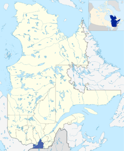
Country  Canada
Province  Quebec
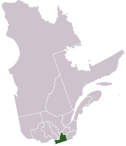
Regional County Municipalities (RCM) and Equivalent Territories (ET) Area[1] – Total 11,851 km2 (4,575.7 sq mi) – Land 11,110.8 km2 (4,289.9 sq mi) Population (2010)[1] – Total 1,441,423 – Density 121.6/km2 (315/sq mi) Demonym Montérégien(ne) Time zone EST (UTC-5) – Summer (DST) EDT (UTC-4) Postal code J Area code 450, 579 Website monteregie.gouv.qc.ca [1] Montérégie is an administrative region in the southwestern corner of Quebec. It includes the cities of Boucherville, Brossard, Granby, Longueuil, Salaberry-de-Valleyfield, Saint-Jean-sur-Richelieu, Saint-Hyacinthe, Sorel-Tracy, and Vaudreuil-Dorion.
The majority of the population lives near the Saint Lawrence River, on the south shore of Montreal.
The region has a population of 1,403,360 (2007 estimates) on 11,127.74 km² (4,296.44 sq mi) of land, giving a population density of 126.1 hab/km² (326.6 hab/sq mi). This is the largest population of any of Quebec's regions besides Montréal. In August 2004, unemployment was 7.9%.
Montérégie is named for the Monteregian Hills, which are in turn named for Mount Royal.
The Montérégie region was populated by the Iroquois when the Europeans first came here in the beginning of the 17th century. Samuel de Champlain built several forts to protect the colonists against the Iroquois and against the British. Some of the battles which decided the destiny of Canada took place in Montérégie.
Montérégie is also well-known for its vineyards, orchards, spectacular panoramas, delicious products, and, of course, for the Monteregian Mountains or Hills, which gave this land its name.
Contents
Regional County Municipalities
There are 14 Regional County Municipalities in Montérégie.
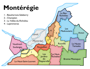
- Acton
- Beauharnois-Salaberry
- Brome-Missisquoi
- La Haute-Yamaska
- La Vallée-du-Richelieu
- Le Haut-Richelieu
- Le Haut-Saint-Laurent
- Les Jardins-de-Napierville
- Les Maskoutains
- Marguerite-d'Youville (formerly Lajammerais until January 2011)
- Pierre-De Saurel (formerly La Bas-Richelieu until January 2009)
- Roussillon
- Rouville
- Vaudreuil-Soulanges
Independent cities
- Urban agglomeration of Longueuil
- Longueuil
- Borough of Greenfield Park
- Borough of Vieux-Longueuil
- Borough of Saint-Hubert
- Boucherville
- Brossard
- Saint-Bruno-de-Montarville
- Saint-Lambert
- Longueuil
Native Reserves
Major communities
- Saint-Constant
- Saint-Hyacinthe
- Saint-Jean-sur-Richelieu
- Sainte-Julie
- Saint-Lambert
- Saint-Lazare
- Salaberry-de-Valleyfield
- Sorel-Tracy
- Varennes
- Vaudreuil-Dorion
References
- ^ a b c "La Montérégie, ses municipalités régionales de comté (MRC) et territoire équivalent (TE) et ses territoires de conférence régionale des élus (CRÉ)" (in French). Profils des régions et des MRC. Quebec: Institut de la statistique du Québec. 2011. http://www.stat.gouv.qc.ca/regions/profils/region_16/region_16_00.htm. Retrieved 20 November 2011.
External links
- Portail régional de la Montérégie Official website
- Montérégie Travel guide
Administrative divisions of Montérégie (Region 16)Regional county municipalities
and equivalent territoriesBrome-Missisquoi · La Haute-Yamaska · Acton · Pierre-De Saurel · Les Maskoutains · Rouville · Le Haut-Richelieu · La Vallée-du-Richelieu · Longueuil · Marguerite-d'Youville · Roussillon · Les Jardins-de-Napierville · Le Haut-Saint-Laurent · Beauharnois-Salaberry · Vaudreuil-Soulanges
Municipalities Cowansville · Granby · Sorel-Tracy · Saint-Hyacinthe · Saint-Jean-sur-Richelieu · Chambly · Saint-Basile-le-Grand · Mont-Saint-Hilaire · Belœil · Brossard · Saint-Lambert · Boucherville · Saint-Bruno-de-Montarville · Longueuil · Sainte-Julie · Varennes · La Prairie · Candiac · Sainte-Catherine · Saint-Constant · Mercier · Châteauguay · Beauharnois · Salaberry-de-Valleyfield · Pincourt · Vaudreuil-Dorion · Saint-Lazare
Administrative divisions of QuebecSubdivisions Communities Major cities Montreal · Quebec · Laval · Gatineau · Longueuil · Sherbrooke · Saguenay · Lévis · Trois-Rivières
Regions Abitibi-Témiscamingue · Bas-Saint-Laurent · Capitale-Nationale · Centre-du-Québec · Chaudière-Appalaches · Côte-Nord · Estrie · Gaspésie–Îles-de-la-Madeleine · Laval · Lanaudière · Laurentides · Mauricie · Montérégie · Montréal · Nord-du-Québec · Outaouais · Saguenay–Lac-Saint-Jean
Coordinates: 45°23′23.4″N 73°6′4.6″W / 45.389833°N 73.101278°W
Categories:- Montérégie
- Montérégie geography stubs

Wikimedia Foundation. 2010.