- Mont-Tremblant, Quebec
-
"Mont-Tremblant" redirects here. For other uses, see Mont-Tremblant (disambiguation).
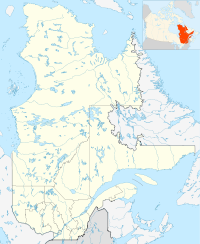
Mont-Tremblant Nickname(s): Tremblant Coordinates: 46°13′N 74°35′W / 46.217°N 74.583°W Country  Canada
Province  Quebec
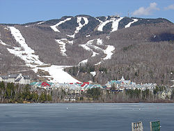
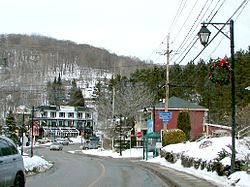
Region Laurentides RCM Les Laurentides Settled Incorporation November 22, 2000 Government - Type Ville - Mayor Pierre Pilon Area[1] - Total 235.97 km2 (91.1 sq mi) - Land 234.40 km2 (90.5 sq mi) Population (2006)[2] - Total 8,892 - Density 37.9/km2 (98.2/sq mi) Time zone EST (UTC-5) - Summer (DST) EDT (UTC-4) Postal Code J8E Area code(s) 819 Website Ville de Mont-Tremblant Mont-Tremblant is a city in the Laurentian mountains of Quebec, Canada, approximately 130 kilometres (81 mi) north-west of Montreal and 140 kilometres (87 mi) north-east of Ottawa. The current municipality with city status was formed in 2000. Mont-Tremblant is most famous for ski resorts such as the Mont-Tremblant Ski Resort, which is 13 kilometres from the village proper, at the foot of a mountain called Mont Tremblant (derived from local Algonquins who referred to it as the "trembling mountain").[citation needed] The largest population centre in Mont-Tremblant is Saint-Jovite.
Mont-Tremblant has a race track called Circuit Mont-Tremblant. It once hosted Formula One, Can-Am, Trans-Am, and Champ Car World Series competitions.
The surrounding area also features hiking, cycling, canoeing, golfing, and a host of other outdoor activities.
Since the summer of 2006, Mont-Tremblant has its own senior amateur Football, the Mystral. It also has a Junior AA hockey team, Les Diables (Devils).
Contents
History
The city of Mont-Tremblant, was created in 2000 from the merger of the municipalities of Mont-Tremblant and Lac-Tremblant-Nord, the village of Saint-Jovite, and the parish of Saint-Jovite. After a referendum, the municipality of Lac-Tremblant-Nord decided to part from the new city and returned to its former status as municipality in 2006.
Education
The city has five elementary schools on its territory, one high school, one professional training school, and one public college.
Elementary schools: Fleur-Soleil, La-Doyenne, La Ribambelle, Tournesol, Trois Saisons
High school: École Polyvalente Curé-Mercure
Professional training school: Centre Le Florès
college Centre Collégial de Mont-Tremblant[3] (also called CEGEP de Saint-Jerome Mont-Tremblant campus)
Demographics
Population:[3]
Population in 2006: 8892
Population in 2001: 8317 (adjusted for boundary change)
Population total in 1996:
Mont-Tremblant: 977
Lac-Tremblant-Nord: 4
Saint-Jovite (ville): 4609
Saint-Jovite (parish): 1708
Population in 1991:
Mont-Tremblant: 707
Lac-Tremblant-Nord: 7000
Saint-Jovite (ville): 4118
Saint-Jovite (parish): 1275
Total private dwellings, excluding seasonal cottages: 3873 (total: 6628)
Mother tongue:
English as first language: 7.7 %
French as first language: 90 %
English and French as first language: 0.7 %
Other as first language: 1.6 %
See also
- Gray Rocks
- Mont-Tremblant public transit
References
External links
- Ville de Mont-Tremblant
- A la découverte de Mont-Tremblant (video)
- Mont-Tremblant Local Newspaper - Tremblant Express

Labelle Lac-Supérieur 
Lac-Tremblant-Nord
La Conception
Brébeuf
Lac-Supérieur
Saint-Faustin–Lac-Carré Mont-Tremblant

Huberdeau Arundel Montcalm Les Laurentides Regional County Municipality Cities/towns Barkmere • Mont-Tremblant • Sainte-Agathe-des-MontsMunicipalities Huberdeau • Ivry-sur-le-Lac • Labelle • La Conception • Lac-Supérieur • Lac-Tremblant-Nord • La Minerve • Lantier • Montcalm • Sainte-Lucie-des-Laurentides • Saint-Faustin–Lac-Carré • Val-des-Lacs • Val-MorinTownships Parishes Villages Other RCMs in Laurentides: Antoine-Labelle • Argenteuil • Deux-Montagnes • La Rivière-du-Nord • Les Pays-d'en-Haut • Thérèse-de-Blainville • Mirabel (Independent city)  Administrative divisions of Laurentides (Region 15)
Regional county municipalities
and equivalent territoriesDeux-Montagnes · Thérèse-de-Blainville · Mirabel · La Rivière-du-Nord · Argenteuil · Les Pays-d'En-Haut · Les Laurentides · Antoine-Labelle
Municipalities Saint-Eustache · Deux-Montagnes · Sainte-Marthe-sur-le-Lac · Pointe-Calumet · Boisbriand · Sainte-Thérèse · Blainville · Rosemère · Lorraine · Bois-des-Filion · Sainte-Anne-des-Plaines · Mirabel · Saint-Colomban · Saint-Jérôme · Sainte-Sophie · Prévost · Saint-Hippolyte · Lachute · Brownsburg-Chatham · Estérel · Sainte-Marguerite-du-Lac-Masson · Sainte-Adèle · Saint-Sauveur · Sainte-Agathe-des-Monts · Barkmere · Mont-Tremblant · Rivière-Rouge · Mont-Laurier
Administrative divisions of Quebec Coordinates: 46°12′44″N 74°35′08″W / 46.21222°N 74.58556°W
Categories:- Incorporated places in Laurentides
- Cities and towns in Quebec
- Quebec communities with significant anglophone populations
Wikimedia Foundation. 2010.


