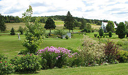
- Arundel, Quebec
-
Arundel Coordinates: 45°58′N 74°37′W / 45.967°N 74.617°W Country  Canada
Province  Quebec
Region Laurentides Regional County Les Laurentides Settled 1854 Incorporated January 1, 1878 Government - Type Township - Mayor Johanna Earle - Federal riding Laurentides—Labelle - Prov. riding Argenteuil Area[1] - Land 65.09 km2 (25.1 sq mi) Population (2006)[1] - Total 601 - Density 9.2/km2 (23.8/sq mi) Demonym Arundelite Time zone EST (UTC-5) - Summer (DST) EDT (UTC-4) Postal Code J0T Area code(s) 819 Website www.municipalite.arundel.qc.ca Arundel is a township in Quebec, Canada, located 18 kilometres (11 mi) south of Mont Tremblant.
Arundel was settled by Scottish and Irish immigrants in the mid-19th century who established subsistence farming operations and worked the forests in winter.
Today most of the land is reserved for agricultural use despite strong growth in the region. Much of Arundel borders the Rouge River.
Demographics
Population:[2]
- Population in 2006: 601 (2001 to 2006 population change: 8.3 %)
- Population in 2001: 555
- Population in 1996: 533
- Population in 1991: 555
Private dwellings, excluding seasonal cottages: 269 (total: 383)
Mother tongue:
- French as first language: 56 %
- English as first language: 38 %
- English and French as first language: 4 %
- Other as first language: 2 %
References
External links
- Canton Arundel Website
- Tweedsmuir Village History
- Laurentian regional website
- Historic Knox Church
- Rouge River Valley

Mont-Tremblant Saint-Faustin–Lac-Carré 
Huberdeau 
Montcalm, Barkmere  Arundel

Harrington Les Laurentides Regional County Municipality Cities/towns Municipalities Huberdeau • Ivry-sur-le-Lac • Labelle • La Conception • Lac-Supérieur • Lac-Tremblant-Nord • La Minerve • Lantier • Montcalm • Sainte-Lucie-des-Laurentides • Saint-Faustin–Lac-Carré • Val-des-Lacs • Val-MorinTownships Amherst • ArundelParishes Villages Other RCMs in Laurentides: Antoine-Labelle • Argenteuil • Deux-Montagnes • La Rivière-du-Nord • Les Pays-d'en-Haut • Thérèse-de-Blainville • Mirabel (Independent city) Coordinates: 45°57′46″N 74°36′57.5″W / 45.96278°N 74.615972°W
Categories:- Townships of Quebec
- Incorporated places in Laurentides
- Quebec communities with significant anglophone populations
- Quebec geography stubs
Wikimedia Foundation. 2010.

