- Mont-Tremblant National Park
-
Mont-Tremblant National Park (French) Parc national du Mont-Tremblant IUCN Category II (National Park)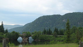
Location Les Laurentides, Matawinie and Antoine-Labelle RCMs, Quebec, Canada Nearest city Mont-Tremblant Coordinates 46°26′00″N 74°21′00″W / 46.4333333°N 74.35°WCoordinates: 46°26′00″N 74°21′00″W / 46.4333333°N 74.35°W Area 1,510.10 km2 (583.05 sq mi) Established March 1, 1981 Governing body SEPAQ Mont-Tremblant National Park (French: Parc national du Mont-Tremblant) is a 1,510.10 km² provincial park located north of the town of Mont-Tremblant, Quebec, and the village of Saint-Donat and Saint-Côme. It is the second largest national park in Quebec after Kuururjuaq National Park.
The park lies within the Eastern forest-boreal transition ecoregion.[1]
Contents
Activities
Summer and Fall
- Via ferrata du Diable
- Swimming
- Golfing
- Canoeing
- Canoe Camping
- Fishing
- Hiking
- Backpacking
- Cycling
Winter
- Snowshoeing
- Backcountry Skiing (Overnight Trips)
- Snow Walking
References
- ^ Olson, D. M, E. Dinerstein, et al (2001). "Terrestrial Ecoregions of the World: A New Map of Life on Earth". BioScience 51 (11): 933–938. doi:10.1641/0006-3568(2001)051[0933:TEOTWA]2.0.CO;2. http://gis.wwfus.org/wildfinder/.
See also
- List of Birds in Mont-Tremblant National Park
- National Parks of Canada
- List of National Parks of Canada
- List of Quebec national parks
External links
Protected areas of Quebec National Parks of Canada Other Federal Parks National Parks of Quebec Aiguebelle · Anticosti · Bic · Frontenac · Gaspésie · Grands-Jardins · Hautes-Gorges-de-la-Rivière-Malbaie · Île-Bonaventure-et-du-Rocher-Percé · Îles-de-Boucherville · Jacques-Cartier · Kuururjuaq · Miguasha · Mont-Mégantic · Mont-Orford · Mont-Saint-Bruno · Mont-Tremblant · Monts-Valin · Oka · Pingualuit · Plaisance · Pointe-Taillon · Saguenay · Saguenay-St. Lawrence · YamaskaBiodiversity reserves Lacs-Vaudray-et-JoannèsEcological reserves Aigle-à-Tête-Blanche · André-Linteau · André-Michaux · Bog-à-Lanières · Boisé-des-Muir · Caribous-de-Jourdan · Chicobi · Charles-B.-Banville · Chênaie-des-Îles-Finlay · Claude-Mélançon · Couchepaganiche · Dunes-de-Berry · Dunes-de-la-Moraine-d'Harricana · Érablière-du-Trente-et-Un-Milles · Ernest-Lepage · Fernald · Forêt-la-Blanche · G.-Oscar-Villeneuve · Grand-Lac-Salé · Grande-Rivière · Grands-Ormes · Île-Brion · Île-Garth · Îles-Avelle-Wight-et-Hiam · Irénée-Marie · Irène-Fournier · Jackrabbit · James-Little · J.-Clovis-Laflamme · Judith-De Brésoles · Jules-Carpentier · Kettles-de-Berry · Lac-à-la-Tortue · Lac-Malakisis · Léon-Provancher · Lionel-Cinq-Mars · Louis-Babel · Louis-Ovide-Brunet · Louis-Zéphirin-Rousseau · Manche-d'Épée · Marcel-Léger · Marcelle-Gauvreau · Marcel-Raymond · Marie-Jean-Eudes · Matamec · Micocoulier · Mine-aux-Pipistrelles · Mont-Saint-Pierre · Père-Louis-Marie · Pin-Rigide · Pointe-Heath · Pointe-Platon · Presqu'île-Robillard · Ristigouche · Rivière-aux-Brochets · Rivière-du-Moulin · Rivière-Rouge · Rolland-Germain · Ruisseau-de-l'Indien · Samuel-Brisson · Serpentine-de-Coleraine · Tantaré · Tapani · Thomas-Fortin · Thomas-Sterry-Hunt · Tourbières-de-Lanoraie · Vallée-du-Ruiter · Victor-A.-Huard · Vieux-Arbres · William-BaldwinWildlife reserves Ashuapmushuan · Assinica · Chic-Chocs · Lacs-Albanel-Mistassini-et-Waconichi · Dunière · Laurentides · La Vérendrye · Mastigouche · Matane · Papineau-Labelle · Port-Cartier-Sept-Îles · Port-Daniel · Portneuf · Rimouski · Rouge-Matawin · Saint-MauriceSee also: Sépaq, Protected areas of Canada, List of Canadian provincial parks Categories:- IUCN Category II
- Parks in Quebec
- Visitor attractions in Laurentides
- Visitor attractions in Lanaudière
- Quebec geography stubs
- Canadian protected area stubs

Wikimedia Foundation. 2010.