- Ontario Highway 33
-
Highway 33

Loyalist Parkway Route information Maintained by the Ministry of Transportation of Ontario Length: 60.9 km[1] (37.8 mi) Existed: July 9, 1930 – present Major junctions West end:  Highway 62 in Bloomfield
East end: Collins Bay Rd. in Kingston Highway system Ontario provincial highways
400-series • Former←  Highway 28
Highway 34  →
→King's Highway 33, commonly referred to as Highway 33, is a provincially maintained highway in the Canadian province of Ontario. The route begins at Highway 62 in Bloomfield and travels east to the Collins Bay Road junction at Collins Bay in the city of Kingston, a distance of 60.9 kilometres (37.8 mi). The highway continues further east into Kingston as Bath Road (Kingston Road 33), ending at the former Highway 2, now Princess Street. Highway 33 is divided into two sections by the Bay of Quinte. The Glenora Ferry service crosses between the two sections just east of Picton, transporting vehicles and pedestrians for free throughout the year.
Originally, Highway 33 continues northeast through Trenton to the town of Stirling, ending as a junction with Highway 14. This section was transferred to county governments by the beginning of 1998. In 2009, Highway 33 became the site of the first modern roundabout on a provincial highway west of Picton.
In 1984, Queen Elizabeth commemorated Highway 33 between Trenton and Kingston as the Loyalist Parkway at a ceremony in Amherstview in honour of the settlers that landed there in 1784.
Contents
Route description
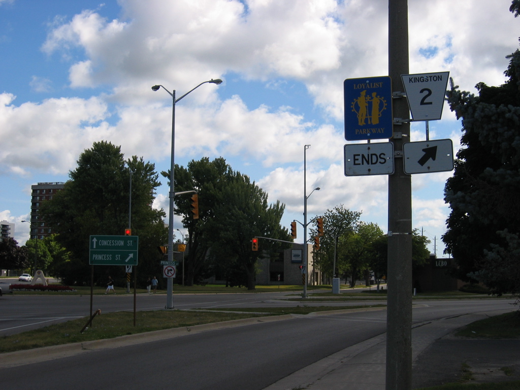
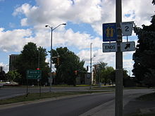 Eastern terminus of Loyalist Parkway and Kingston Road 33 in Kingston
Highway 33, known as the Loyalist Parkway throughout its length, begins in the west at the southern terminus of Highway 62, west of which the parkway continues as Prince Edward County Road 33 to Trenton. The route begins within the community of Bloomfield. To the east it crosses several creeks then intersects Prince Edward County Road 1 at the first modern provincially maintained roundabout. East of this, the highway enters into the city of Picton.[2]
Within Picton, Highway 33 intersects the former Highway 49, now Prince Edward County Road 49. It exits the city and follows the southeastern shoreline of Picton Bay, passing the H.J. McFarland Conservation Area midway between the city and Glenora.[2]
Glenora–Adolphustown Ferry service[3] mid-May – September 6:00am–10:00am
7:30pm–1:15am30 minute service 10:15am–7:30pm 15 minute service Winter 6:00am–1:15am 30 minute service Highway 33 has two sections, which are joined by the Glenora Ferry, an auto ferry crossing the Bay of Quinte from Glenora to Adolphustown. The Ministry of Transportation of Ontario (MTO), which maintains Highway 33, also provides the ferry service free of charge.[3] The eastern section of the highway begins west of Adolphustown, where it passes by several Loyalist heritage sites. Now in the county of Lennox and Addington, the route remains close to the shores of the Bay of Quinte for the remainder of its journey towards Kingston. It divides the Greater Napanee communities of Conway, South Fredericksburg, Parma, Sandhurst Shores and Sandhurst, then enters the municipality of Loyalist opposite Amherst Island. The highway passes through Bath, after which it follows the Bath Road, one of the oldest roads in Ontario,[4] built circa 1785.[5] At Millhaven, a ferry service provides access to Amherst Island;[3] Highway 33 continues east and passes through Amherstview before crossing the county line into Frontenac County and the City of Kingston.[2]
The short section of Highway 33 within Kingston travels as far east as Collins Bay Road (County Road 2), in the community of Collins Bay. From this point, the road continues east as Bath Road (Kingston City Road 33), ending downtown at Princess Street, formerly Highway 2.[2]
Highway 33 is 60.9 kilometres (37.8 mi) in length, excluding the length of the Glenora Ferry. Traffic volumes vary considerably throughout the length of the route. On an average day, over 5,000 vehicles travel the section between Bloomfield and Picton. Between Picton and the Glenora Ferry, volumes drop to under 2,000. On the opposite shore, traffic volumes grow from over 6,000 near bath to over 11,000 outside of Kingston.[1]
History
Highway 33 is also known as the Loyalist Parkway, a title it was given in 1984 by Queen Elizabeth to commemorate the role of the route two hundred years prior. The route connects several historical settlement sites in Prince Edward County. In 1784, following the American Revolution, the United Empire Loyalists began to arrive in Upper Canada, hoping to settle the frontier near Cataraqui (now Kingston). With the help of the military, the loyalists blazed a trail west from Cataraqui to Bath, a distance of 25 kilometres (16 mi). This trail would become a section of Highway 33 nearly 150 years later.[5][4]
Ironically, the first section of Highway 33 to be assumed would not be commemorated as part of the Loyalist Parkway. On July 9, 1930, the Department of Highways assumed the Trenton–Stirling Road as King's Highway 33, a distance of approximately 25 kilometres (16 mi).[6] Several years later, as part of depression-relief work undertaken by the department in the early 1930s, the Carrying Place Trail through Prince Edward County and the United Counties of Lennox and Addington was assumed as an extension of Highway 33. The section between Trenton and Glenora was assumed on July 4, 1934, while the section between Adolphustown and Kingston was assumed several days later on July 11.[7]
In 1984, Queen Elizabeth toured the Kingston area as part of its two hundredth anniversary, attending several events and ceremonies through her visit. On her final day in the region, she dedicated the Loyalist Parkway in honour of the settlers that landed there in 1784. The ceremony was held in Amherstview on September 27, 1984.[8]
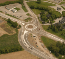 The Highway 33 and Prince Edward County Road 1 roundabout in mid-construction
In 2009, intersection of Highway 33 and Prince Edward County Road 1 (Scoharie Road) near Picton saw the introduction of a traffic roundabout, the first ever constructed on a provincial highway in the province, to replace the at-grade intersection.[9] The MTO felt that the area had reached its operational threshold due to high tourist and recreational activity, particularly during the busy summer months, and so felt a traffic roundabout was needed.[10]
The engineering and consulting firm Morrison Hershfield was retained to undertake the detail design for the realignment and reconfiguration of the existing intersection at Highway 33 and Country Road 1 into a single lane roundabout with a central island and truck apron. The assignment included highway engineering, drainage and hydrology engineering, electrical engineering, public consultation, and traffic engineering.[10] The roundabout was officially opened on July 17, 2009.[9]
Major intersections
The following table lists major intersections located along Highway 33.[2]
Division Location km[1] Destinations Notes  Highway 33 continues west as the Loyalist Parkway
Prince Edward County Bloomfield 0.0 Highway 62 north – BellevilleBeginning of Bloomfield Connecting Link agreement[11] 2.1 End of Bloomfield Connecting Link agreement[11] Warings Corner 4.8 County Road 1 Roundabout Picton 6.8 Mill Street Picton city limits; beginning of Connecting Link agreement Formerly Highway 49 9.5 Picton city limits; end of Connecting Link agreement Glenora 17.0 Highway 33 crosses Bay of Quinte via Glenora Ferry Lennox and Addington Greater Napanee 36.6 County Road 21 (Napanee Road) Bath 43.6–46.4 Bath Connecting Link agreement Millhaven 48.1 County Road 4 Loyalist 55.0 County Road 6 – Odessa Amherstview 57.0 Sherwood Avenue 58.4 County Road 24 (Coronation Boulevard) Lennox & Addington – Frontenac boundary Frontenac County Kingston 60.9 County Road 2 (Collins Bay Road) Beginning of former Kingston Connecting Link agreement 68.9 Road 2 (Princess Street) Formerly Highway 2 See also
References
- ^ a b c Ministry of Transportation of Ontario (2008). "Annual Average Daily Traffic (AADT) counts". Government of Ontario. http://www.raqsb.mto.gov.on.ca/techpubs/TrafficVolumes.nsf/tvweb?OpenForm&Seq=5. Retrieved November 4, 2011.
- ^ a b c d e Peter Heiler Ltd (2010). Ontario Back Road Atlas (Map). pp. 68, section N–Q71. ISBN 978-1-55198-226-7.
- ^ a b c Ministry of Transportation of Ontario. "Kingston Area Ferry Information". Government of Ontario. http://www.mto.gov.on.ca/english/traveller/ferry. Retrieved November 4, 2011.
- ^ a b McKendry, Jennifer. "Chronology of the History of Kingston". Kingston Historical Society. http://www.kingstonhistoricalsociety.ca/chrono.html. Retrieved November 4, 2011.
- ^ a b Mika, Nick; Mika, Helma (1976). United Empire Loyalists : Pioneers of Upper Canada. Mika Publishing Company. pp. 167–168. ISBN 0-919303-09-9.
- ^ Annual Report (Report). Department of Highways. March 31, 1932. p. 76.
- ^ Annual Report (Report). Department of Highways. March 31, 1935. p. 119.
- ^ Canadian Press (September 28, 1984). "Battle Re-enacted for Queen, Philip". The Leader–Post (Regina, Saskatchewan): p. A2. http://news.google.com/newspapers?id=unBWAAAAIBAJ&sjid=N0ENAAAAIBAJ&pg=2977,2828597&dq=loyalist-parkway&hl=en. Retrieved August 17, 2011.
- ^ a b Highway 33 Roundabout, Ontario Ministry of Transportation.
- ^ a b "Highway 33 Roundabout Project Page". Morrison Hershfield. http://www.morrisonhershfield.com/solutions/Pages/Highway33Roundabout.aspx. Retrieved August 30, 2011.
- ^ a b Contract Management and Operations Branch (2011). Highway Connecting Link List (Report). Ministry of Transportation of Ontario. p. 2.
External links
- Loyalist Parkway
- Highway 33 at OntHighways.com
- Highway 33 Images, including Loyalist Parkway shields
The King's Highways of Ontario Current highwaysFormer highways- 2A
- 2B
- 2S
- 3B
- 4A
- 5A
- 7B
- 8A
- 12B
- 14
- 15A
- 18
- 18A
- 22
- 24A
- 25
- 27
- 29
- 30
- 31
- 32
- 35A
- 35B
- 36
- 38
- 39
- 40B
- 42
- 43
- 44
- 45
- 46
- 47
- 48B
- 50
- 51
- 52
- 53
- 54
- 55
- 56
- 57
- 59
- 68
- 70
- 73
- 74
- 75
- 76
- 78
- 79
- 80
- 81
- 82
- 83
- 84
- 86
- 87
- 88
- 90
- 91
- 92
- 95
- 96
- 97
- 98
- 99
- 100
- 103
- 104
- 106
- 107
- 109
- 110
- 111
- 114
- 116
- 117
- 119
- 120
- 121
- 122
- 123
- 126
- 128
- 131
- 133
- 134
- 135
- 136
- 169
- 400A
- 401A
County roads in Ontario · Ontario numbered highways · Expressways and 400-series highways · King's Highways · Secondary highways · Tertiary and 7000-series highways · List of Ontario provincial highways · List of former provincial highways in Ontario · Highways in Ontario · List of Ontario expressways · Trans-Canada Highway · Connecting Link · Emergency Detour RouteCategories:- Ontario provincial highways

Wikimedia Foundation. 2010.