- Ontario Highway 26
-
Highway 26
Route information Maintained by the Ministry of Transportation of Ontario Major junctions West end: 

 Highway 6 / Highway 10 / Highway 21 in Owen Sound
East end:  Highway 400 in Barrie
Location Major cities: Owen Sound, Meaford, Collingwood, Wasaga Beach, Stayner, Barrie Highway system Ontario provincial highways
400-series • Former←  Highway 24
Highway 28  →
→King's Highway 26, commonly referred to as Highway 26, is a provincially maintained highway in the Canadian province of Ontario, connecting the cities of Barrie and Owen Sound.
Contents
Route description
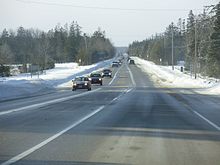 Highway 26 in Springwater, looking west
Highway 26 is Owen Sound and Meaford in the west is not as highly traveled as the tourist area to the east. It is also not a very straight route, as the highway makes four right-hand turns at signalled intersections, including the junction with Simcoe Road 27 (formerly Highway 27) north of Barrie (which is not signalled), the intersection with Simcoe Roads 91 and 42 in downtown Stayner (which lacks a right-hand turn lane), Hume Street in eastern Collingwood, and High street in western Collingwood. Although there is a Realignment Program currently underway.[1]
The routing of the highway takes it from the junction with Highway 6, Highway 10 and Highway 21 in Owen Sound to its terminus at Highway 400 in Barrie at the Bayfield street interchange. For a time the highway continued southward to Dunlop street, formerly Highway 11, in Barrie, cosigned with Highway 27. The southern portion of Bayfield street was downloaded to the City of Barrie along with Dunlop street in 1997, when these sections of Highway 27 and 11 were eliminated. This shortened the highway's length by 1.3 kilometers and removed the 7.2 kilometer concurrency with Highway 27. The highway's current length is 115.7 km.
The highway serves as a major link between Barrie and the Greater Toronto Area (via Highway 400) and the popular tourist region on the southern shore of Georgian Bay. Over the past several years the popularity of this region has increased, and traffic levels have increased accordingly. Major reconstruction work was undertaken to repair the very old bridge over the Nottawasaga River in Edenvale (between Barrie and Stayner).
Pretty River Parkway
Prior to the completion of the Pretty River Parkway in Collingwood in the 1970s, Highway 26 was routed through Collingwood along Hume Street, before making a 90 degree right turn (north) at the intersection with Highway 24 (Now Simcoe Road 124, Hurontario Street) with which it was concurrent until Highway 24's terminus at First Street, where Highway 26 makes a 90 degree left turn (west) onto First Street, continuing on the present route. The Pretty River Parkway was a bypass of this highly congested downtown route, branching off to the north from Hume Street and swinging gradually westward along the shoreline until becoming Huron Street, which is the eastward extension of First Street beyond Hurontario. In 2003, the Pretty River Parkway was widened to two lanes in each direction to match the existing sections of Huron and First Streets, with a stretch between the Pretty River Bridge and Huron Street being divided by a small median. Upgrades to Highway 26 within the town of Collingwood are likely; when the new bypass is completed, this section will be downloaded to the town, which will no longer get provincial funding for its maintenance. This new bypass has been suspended in conclusion, however, and this may never occur.
Future
A major realignment of the highway is currently in the construction phase that will, when completed, bypass the current highway east of the town of Collingwood. The present section of highway between Collingwood and Wasaga Beach is an older and dangerous section of road, with many small intersecting streets and private residences with direct highway entrances, along with very high traffic volumes. The new alignment will have the highway veer west from a point along its present route between Stayner and Wasaga Beach, and parallel the current highway until a point east the Collingwood town limits. It is believed that this section is the first part in realigning the existing highway within the Collingwood area, including a bypass of the town itself, but no other projects or studies are underway that would expand this highway beyond its current length. The new route will be designed as a limited access highway, although it is not known yet if it will be a 2 or 4-lane divided roadway. It is also not known what will happen to the current route of Highway 26, whether it will be assumed as a Simcoe County road, or if it will remain in the provincial highway system.[2]
References
- ^ Ministry of Transportation (April 11, 2003). "Eves Government Invests to Realign Highway 26 in Collingwood Area". Canada NewsWire (Government of Ontario). http://finance.groups.yahoo.com/group/ontroads/message/1634. Retrieved 2007-09-07.
- ^ 〈=_e.html "Harris Government to Enhance Safety and Ease Congestion along Highway 26". Canada NewsWire (Government of Ontario, Canada). http://ogov.newswire.ca/ontario/GPOE/2000/07/10/c2131.html?lmatch= 〈=_e.html. Retrieved 2007-09-07.[dead link]
External links
The King's Highways of Ontario Current highwaysFormer highways- 2A
- 2B
- 2S
- 3B
- 4A
- 5A
- 7B
- 8A
- 12B
- 14
- 15A
- 18
- 18A
- 22
- 24A
- 25
- 27
- 29
- 30
- 31
- 32
- 35A
- 35B
- 36
- 38
- 39
- 40B
- 42
- 43
- 44
- 45
- 46
- 47
- 48B
- 50
- 51
- 52
- 53
- 54
- 55
- 56
- 57
- 59
- 68
- 70
- 73
- 74
- 75
- 76
- 78
- 79
- 80
- 81
- 82
- 83
- 84
- 86
- 87
- 88
- 90
- 91
- 92
- 95
- 96
- 97
- 98
- 99
- 100
- 103
- 104
- 106
- 107
- 109
- 110
- 111
- 114
- 116
- 117
- 119
- 120
- 121
- 122
- 123
- 126
- 128
- 131
- 133
- 134
- 135
- 136
- 169
- 400A
- 401A
County roads in Ontario · Ontario numbered highways · Expressways and 400-series highways · King's Highways · Secondary highways · Tertiary and 7000-series highways · List of Ontario provincial highways · List of former provincial highways in Ontario · Highways in Ontario · List of Ontario expressways · Trans-Canada Highway · Connecting Link · Emergency Detour RouteCategories:- Ontario provincial highways

Wikimedia Foundation. 2010.