- Ontario Highway 138
-
Highway 138
Route information Maintained by the Ministry of Transportation Length: 38.7 km[2] (24.0 mi) Existed: May 1, 1967[1] – present Major junctions South end: 9th Street West – Cornwall
(formerly Highway 2 east)
 Highway 401 (Exit 789)
County Road 43 – Monkland
(formerly Highway 43)North end:  Highway 417 near Casselman
Location Counties: Stormont, Dundas and Glengarry United Counties Towns: Saint Andrews, Monkland Highway system Ontario provincial highways
400-series • Former←  Highway 137
Highway 140  →
→King's Highway 138, commonly referred to as Highway 138, is a provincially maintained highway in eastern Ontario. It extends from the former Highway 2 in Cornwall, north to Highway 417 east of Casselman. Highway 138 provides access to the Seaway International Bridge, connecting Cornwall with Massena, New York. The highway is 38.7 km (24.0 mi) in length.
Highway 138 was first established in 1967, connecting Highway 2, now Vincent Massey Drive, with Highway 43 in Monkland. By the mid-1970s, the route had been extended north to meet with the newly opened Highway 417. Since then it has remained unchanged.
Contents
Route description
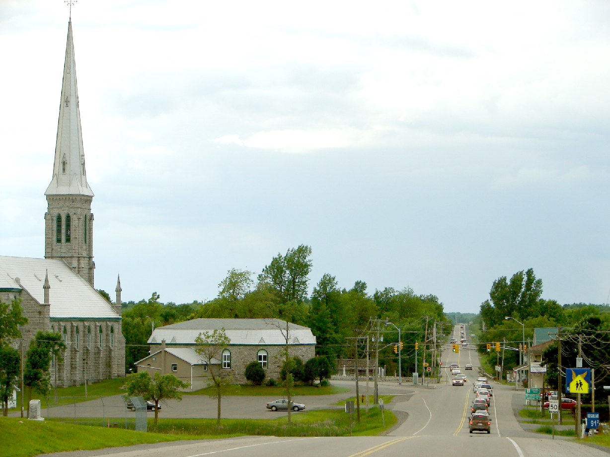
 Highway 138 through St. Andrews West.
Highway 138 is a 36.0-kilometre (22.4 mi) highway that crosses the Laurentian Valley in eastern Ontario, connecting Highway 401 in Cornwall with Highway 417 east of Casselman.[3]
The route begins at 9th Street West, which was Highway 2 until the late 90s, and proceeds north along the western side of Cornwall; this section is maintained under a Connecting Link agreement and is locally known as Brookdale Avenue.[4] After crossing Highway 401, at which there is an interchange, the route encounters Cornwall Centre Road, onto which it turns east. After following it for a brief distance, the highway turns north onto St. Andrews Road; the Connecting Link agreement ends at this junction.[4]
Over the next two kilometres (1.25 mi), the highway exits the fringes of Cornwall, passing through the neighbourhood of Churchill Heights. After passing Headline Road (County Road 44), the route divides a forest and then enters an agricultural area before coming upon the community of St. Andrews West. It crosses the Raisin River and continues north through a mix of farmland and forests.
History
Highway 138 was established by the Department of Highways on May 1, 1967, following existing Stormont County roads between Highway 2 at the Seaway International Bridge and Highway 43.[1] With the construction of Highway 417 planned and progressing eastward from Ottawa, Highway 138 was extended north to its present terminus east of Casselman in 1971 or 1972.[5][6] Its route remained unchanged from then until the mass downloading of highways, during which the southern end was truncated to Highway 401.
Major intersections
The entirety of Highway 138 is located in Stormont, Dundas and Glengarry United Counties.[3]
Location[3] km[2] Destinations Notes Cornwall 0.0 9th Street West Beginning of Cornwall Connecting Link agreement; beginning of former Highway 2 concurrency 0.5 Vincent Massey Drive End of former Highway 2 concurrency 2.7 Highway 401Exit 789 4.3 Cornell Centre Road End of Connecting Link agreement Saint Andrews 8.9 County Road 18 (Kings Road) Monkland 21.8 County Road 43 – Smiths Falls, Winchester, Alexandria Formerly Highway 43 North Stormont 30.6 McNeil Road / Road 22 – Dyer 32.1 County Road 15 (McLean Road) – Moose Creek 38.7 Highway 417 – OttawaReferences
- ^ a b AADT Traffic Volumes 1955–1969 And Traffic Collision Data 1967–1969. Ontario Department of Highways. 1969. p. 114.
- ^ a b Ministry of Transportation of Ontario (2008). "Annual Average Daily Traffic (AADT) counts". Government of Ontario. http://www.raqsb.mto.gov.on.ca/techpubs/TrafficVolumes.nsf/tvweb?OpenForm&Seq=5. Retrieved November 13, 2010.
- ^ a b c Peter Heiler (2010). Ontario Back Road Atlas (Map). Cartography by MapArt. p. 52, section R68–U70. ISBN 978-1-55198-226-7.
- ^ a b Contract Management and Operations Branch (2011). Highway Connecting Link List (Report). Ministry of Transportation of Ontario.
- ^ Ontario Department of Highways (1971). Ontario Road Map (Map). Cartography by Photogrammetry Office. Section Q–R32. http://www.ontarioroadmaps.ca/Official_Ontario/Years/71/71.htm. Retrieved January 2, 2010.
- ^ Ontario Ministry of Transportation and Communications (1973). Ontario Road Map (Map). Cartography by Photogrammetry Office. Section Q–R32. http://www.ontarioroadmaps.ca/Official_Ontario/Years/73/73.htm. Retrieved January 2, 2010.
The King's Highways of Ontario Current highwaysFormer highways- 2A
- 2B
- 2S
- 3B
- 4A
- 5A
- 7B
- 8A
- 12B
- 14
- 15A
- 18
- 18A
- 22
- 24A
- 25
- 27
- 29
- 30
- 31
- 32
- 35A
- 35B
- 36
- 38
- 39
- 40B
- 42
- 43
- 44
- 45
- 46
- 47
- 48B
- 50
- 51
- 52
- 53
- 54
- 55
- 56
- 57
- 59
- 68
- 70
- 73
- 74
- 75
- 76
- 78
- 79
- 80
- 81
- 82
- 83
- 84
- 86
- 87
- 88
- 90
- 91
- 92
- 95
- 96
- 97
- 98
- 99
- 100
- 103
- 104
- 106
- 107
- 109
- 110
- 111
- 114
- 116
- 117
- 119
- 120
- 121
- 122
- 123
- 126
- 128
- 131
- 133
- 134
- 135
- 136
- 169
- 400A
- 401A
County roads in Ontario · Ontario numbered highways · Expressways and 400-series highways · King's Highways · Secondary highways · Tertiary and 7000-series highways · List of Ontario provincial highways · List of former provincial highways in Ontario · Highways in Ontario · List of Ontario expressways · Trans-Canada Highway · Connecting Link · Emergency Detour RouteCategories:- Ontario provincial highways

Wikimedia Foundation. 2010.