- Ontario Highway 144
-
Highway 144
Route information Maintained by the Ministry of Transportation of Ontario Length: 271.7 km[3] (168.8 mi) History: Assumed April 1965[1]
completed September 25, 1970[2]Major junctions South end:  Highway 17 in Sudbury
 Highway 560 / Sultan Industrial Road
Highway 661 – GogamaNorth end:  Highway 101 – Timmins
Highway system Ontario provincial highways
400-series • Former←  Highway 141
Highway 148  →
→King's Highway 144, also known as Highway 144, is a provincially maintained highway in the northern portion of the Canadian province of Ontario, linking the cities of Greater Sudbury and Timmins. The highway is one of the most isolated in Ontario, passing through forest for the majority of its 271 km (168 mi) length. It is patrolled by the Ontario Provincial Police and features an 80 km/h (50 mph) speed limit.
Highway 144 was created by renumbering Highway 544 in April 1965. This was done in preparation for an extension of the short secondary highway, which was completed in 1970. In the mid 1980s, a new route was constructed which allowed Highway 144 to bypass Sudbury, known as the Northwest Bypass.
Contents
Route description
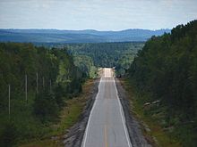 Highway 144 north of Gogama
Highway 144 is 271 km (168 mi) long, lying between its southern terminus at an interchange with Highway 17 west of Lively and its northern terminus at an intersection with Highway 101 west of downtown Timmins. Much of the route is isolated; Cartier is the only community located directly on the highway between Sudbury and Timmins, although Gogama and the Mattagami First Nation are near the highway along side routes.
Between the communities of Dowling and Onaping in Greater Sudbury, Highway 144 is home to the scenic A. Y. Jackson Lookout, overlooking the waterfall depicted in his 1953 painting "Spring on the Onaping River". From here it winds through several small communities before exiting Greater Sudbury. It passes through the village of Cartier, then enters a long isolated stretch surrounded only by endless expanses of the boreal forest.[4] At an isolated point 149 km (93 mi) north of Lively and 117 km (73 mi) south of Timmins, Highway 144 meets Highway 560 and the Sultan Industrial Road, which constitute the only major transportation route intersecting the highway;[3] the rest stop at this intersection is the only gas station located on the highway north of Cartier.
Just north of the Highway 560/Sultan Industrial Road intersection, the highway crosses the Laurentian Divide, the boundary between the Great Lakes and Arctic Ocean watersheds. North of this point, all streams and rivers flow north into Hudson Bay. A sign and a small picnic area mark the transition. The highway continues through isolated forests and curves east to meet Highway 661, a short spur serving the town of Gogama. The highway turns to the north and follows along the western side of Kenogamissi Lake for 70 km (43 mi) to Highway 101, just west of Timmins.[4]
History
Prior to 1964, the highway extended only from Sudbury to Cartier and was designated as Highway 544.[5] Construction began in that year on an extension to Timmins, with work commencing at both ends. The highway number was changed to 144 in April 1965, representing an upgrade from secondary to primary highway status.[1] Despite this, most of the route of Highway 544 was bypassed by a new alignment; the old route is still known as Old Highway 544.[4] The highway was fully opened to traffic by premier John Robarts on September 25, 1970.[2]
Until the 1980s, Highway 144 entered directly into downtown Sudbury along what is now Municipal Road 35; an even older alignment followed a now-closed private road on Vale property north of Copper Cliff, entering downtown Sudbury along the now-residential Spruce Street. In early 1983, contracts were tendered for the grading of the northern 8.7 km (5.4 mi) (the section within what was then the town of Rayside-Balfour). The project was completed by the end of the year, after which a second contract was awarded to grade a further 6 km (3.7 mi). The final grading contract, which included the interchange at Highway 17, was awarded in 1985 and completed in mid-1986. The entire bypass was paved shortly thereafter.[6]
Future
In recent years, heavy traffic has been reported along the route through Chelmsford and Dowling, with an average daily traffic volume of 19,200 vehicles in 2002.[7] The Ministry of Transportation has announced a preliminary study into potential improvements to the route between Chelmsford and Dowling, which may include the possibility of a full bypass realignment.[8]
Municipal Road 35, however, has been widened by the city to accommodate traffic between downtown and the Highway 144 route. A section of Municipal Road 35 between the eastern intersection of Notre Dame Street (Municipal Road 21) in Azilda to Highway 144 in Chelmsford is currently a two-lane highway. There are plans to widen that section of roadway, although no date has been announced.[9]
Major intersections
The following table lists the major junctions along Highway 144.
Division Location km[3] Destinations Notes Greater Sudbury 0.0 Highway 17 – Sault Ste. Marie, North BayTrumpet interchange 4.0 Municipal Road 24 – Creighton Mine, Lively 17.6 Municipal Road 15 / Municipal Road 35 – Valley East May be bypassed in the future by a realignment currently under MTO study. 18.7 St. Albert Street / Charlotte Street 24.1 Municipal Road 13 (Vermilion Lake Road) 28.2 Larchwood Avenue – Onaping Falls 40.9 Municipal Road 8 – Onaping Falls Sudbury District Unorganized Sudbury 73.9 Onaping Lake Road – Onaping Lake Provincial Park 154.0 Highway 560 / Sultan Industrial Road186.0 Highway 661 – Gogama, Mattagami Cochrane District Timmins 271.7 Highway 101 – Timmins, Wawa1.000 mi = 1.609 km; 1.000 km = 0.621 mi References
- ^ a b AADT Traffic Volumes 1955–1969 And Traffic Collision Data 1967–1969. Ontario Department of Highways. 1969. p. 114. "Notes: 2. Hwy. 144 renumbered from Sec. Hwy. 544 in April 1965"
- ^ a b "Robarts, 4 in Cabinet Open Sudbury-Timmins Link". Toronto Daily Star (Canadian Press): p. 3. September 26, 1970.
- ^ a b c Ministry of Transportation of Ontario (2004). "Annual Average Daily Traffic (AADT) counts". Government of Ontario. http://www.raqsb.mto.gov.on.ca/techpubs/TrafficVolumes.nsf/tvweb?OpenForm&Seq=5. Retrieved February 26, 2010.
- ^ a b c Peter Heiler (2010). Ontario Back Road Atlas (Map). Cartography by MapArt. p. 52, section R68–U70. ISBN 978-1-55198-226-7.
- ^ Ontario Department of Highways (1961). Ontario Road Map (Map). Cartography by C.P. Robins. Section R35–S35.
- ^ Northern Transportation Construction Projects 1986-87 (Report). Ministry of Northern Development and Mines. April 1, 1986. p. VII. ISSN 0822-1480.
- ^ City of Greater Sudbury Transportation Study
- ^ "Heavy traffic irks Dowling residents". Northern Life, September 8, 2010.
- ^ City of Greater Sudbury Municipal Road 35 Widening from Notre Dame Street to Chelmsford
External links
The King's Highways of Ontario Current highwaysFormer highways- 2A
- 2B
- 2S
- 3B
- 4A
- 5A
- 7B
- 8A
- 12B
- 14
- 15A
- 18
- 18A
- 22
- 24A
- 25
- 27
- 29
- 30
- 31
- 32
- 35A
- 35B
- 36
- 38
- 39
- 40B
- 42
- 43
- 44
- 45
- 46
- 47
- 48B
- 50
- 51
- 52
- 53
- 54
- 55
- 56
- 57
- 59
- 68
- 70
- 73
- 74
- 75
- 76
- 78
- 79
- 80
- 81
- 82
- 83
- 84
- 86
- 87
- 88
- 90
- 91
- 92
- 95
- 96
- 97
- 98
- 99
- 100
- 103
- 104
- 106
- 107
- 109
- 110
- 111
- 114
- 116
- 117
- 119
- 120
- 121
- 122
- 123
- 126
- 128
- 131
- 133
- 134
- 135
- 136
- 169
- 400A
- 401A
County roads in Ontario · Ontario numbered highways · Expressways and 400-series highways · King's Highways · Secondary highways · Tertiary and 7000-series highways · List of Ontario provincial highways · List of former provincial highways in Ontario · Highways in Ontario · List of Ontario expressways · Trans-Canada Highway · Connecting Link · Emergency Detour RouteCategories:- Ontario provincial highways
- Roads in Sudbury District, Ontario
- Roads in Cochrane District, Ontario


Wikimedia Foundation. 2010.