- Ontario Highway 6
-
Highway 6
Garafraxa Road 
Route information Length: 480 km[1] (300 mi) Existed: 1920 – present Major junctions South end: St. Patrick Street - Port Dover  Highway 3 – Jarvis
 Highway 403 – Ancaster
 Highway 401 – Morriston
 Highway 7 – Guelph
 Highway 89 – Mount Forest
 Highway 10 – Chatsworth

 Highway 21 / Highway 26 – Owen Sound
North end:  Highway 17 – Baldwin
Location Major cities: Owen Sound, Guelph, Hamilton, Haldimand Towns: Espanola, Fergus, Hagersville, Mount Forest, Port Dover, Wiarton Highway system Ontario provincial highways
400-series • Former←  Highway 5
Highway 7  →
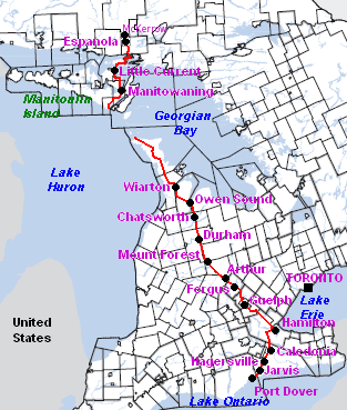
→King's Highway 6, also known as Highway 6, is a provincially maintained highway in the Canadian province of Ontario. It crosses a distance of 480 km (300 mi) between Port Dover on the north shore of Lake Erie and Espanola on the northern shore of Lake Huron, ending at the Trans-Canada Highway (Highway 17) in McKerrow.[2]
Contents
Route description
Port Dover to Hamilton
Highway 6 begins at Saint Patrick Street in the community of Port Dover, and stretch northward as a two-lane, undivided highway. The road travels into Haldimand County, through communities such as Jarvis and Hagersville, and the traffic flow increases.[3] By the time the highway reaches Caledonia, the road by-passes the former Highway 6 section (Argyle Street), which passes the town centre of Caledonia. With the newly built by-pass, Highway 6 is routed outside the urban centre of Caledonia. The Caledonia By-Pass was opened in 1983, and is a two-lane undivided freeway [4]. The bypass terminates at Greens Road on the north side of Caledonia and Highway 6 proceeds eastbound on Greens Road for approximately 500m to Argyle St North. Highway 6 then turns north on a 4-lane undivided alignment for 5 km. Much of the old alignment north to near Rymal Road remains provincially maintained as unsigned Highway 7273[4]. In Hamilton, Highway 6 now uses a new alignment from Highway 403 to south of the Hamilton Airport, connecting with the southerly leg to Caledonia and Port Dover. The new alignment opened as an undivided two-lane freeway; it is expected to expand to a full 4-lane divided highway, and to extend to past Caledonia, by some time in the 2010s. As the road meets Highway 403, Highway 6 merges with Highway 403, and there is a concurrency for 17 kilometres. The concurrency ends at the Highway 6 junction, at the Hamilton/Burlington boundary, near the Royal Botanical Gardens.
Hamilton to Guelph
 Highway 6 descends the Niagara Escarpment through the Clappison Cut towards Burlington as a five lane freeway
Though most of the route is five lanes — two travel lanes in each direction, plus one centre lane for left turns — the section in Wellington County from Puslinch to Morriston has remained two lanes because of its route through several small towns and a lack of available property for widening; this area therefore suffers from significant congestion. A new alignment, connecting to the Hanlon Parkway at Highway 401, is being considered to bypass this troubled section. The section where Highway 6 is concurrent with Highway 401 has the highest AADT (Annual Average Daily Traffic), at 85,000 automobiles per day in 2002. High travel speeds in the five-lane section, and typical flow varies between 100 km/h (65 mph) and 120 km/h (75 mph).
The section of Highway 6 between Highway 403 in Hamilton and Clappison's Corners (the intersection at Hwy 5 West) was converted in 2009 to a controlled access freeway with an interchange at York Road. The interchange opened on May 23, 2009, and simultaneously, the intersection where Northcliffe/Plains Road met Highway 6 was closed permanently. (A new service road was built on either side to connect Plains Road and various other residential streets to the York Road interchange.) This section of Highway 6 has two southbound lanes and three northbound, the extra lane being for trucks climbing the steep escarpment, as well as high mast lighting and a full concrete median barrier.
In Guelph, the road travels along the full length of the Hanlon Parkway - a 4-lane, controlled access and divided highway with signalized level crossings. The Ministry of Transportation is presently investigating the possibility of changing these intersections into grade-separated interchanges. For 4 km Highway 6 is concurrent with Highway 7, from the Wellington Street interchange north to where the Hanlon Parkway ends at Woodlawn Road. At Woodlawn, Highway 7 veers west, and Highway 6 continues east. Following Woodlawn, Highway 6 then veers north onto Woolwich Street, leaving the city of Guelph.
Guelph to Owen Sound

As Highway 6 leaves Guelph and headed northwards, the highway narrows into two lanes. The road passes Fergus (at Wellington County Road 18); Arthur (at Wellington County Road 12, 14, and 109 junction); Mount Forest (at the Highway 89 junction); and Durham (at Grey County Road 4).
32 km north of Durham, Highway 6 is concurrent with Highway 10 at the community of Chatsworth. For the next 13 km, Highway 6 remains concurrent with Highway 10 until it approaches the outer edge of the urban area of Owen Sound. There is an election promise to upgrade this 13 km to a 400-series Highway and rename it Highway 410.
Near Owen Sound City Centre, and upon the end of Highway 10, Highway 6 is concurrent with Highway 21 for 6 km westward to Springmount. This portion is a 4-lane arterial road (as seen in the image).
Owen Sound to Tobermory
 Highway 6 looking south near Wiarton.
 Chi-Cheemaun docking at Carlton Street.
At Springmount, Highway 6 ends its concurrency with Highway 21, and continues northwards into the Bruce Peninsula. The road remains as a two-lane highway for its full length up to Tobermory. Highway 6 spans 110 km on the Bruce Peninsula. Highway 6 passes through communities such as Shallow Lake, Hepworth, Wiarton, and Ferndale. Highway 6 is also named as Berford Street in Wiarton, and 10th Street in Owen Sound.[5] Along the road, Bruce Peninsula National Park could also be found. At Tobermory, Highway 6 is designated via Carlton Road and Front Street, where motorists wait for the Chi-Cheemaun Ferry to arrive. In the reverse direction, motorists disembarking from the Chi-Cheemaun ferry use Carlton Street to return to Highway 6. Highway 6 discontinues at Tobermory, and motorists are required to travel on the tolled ferry, MS Chi-Cheemaun, also known as simply Chi-Cheemaun, to continue traveling on Highway 6 on Manitoulin Island.[6] The journey from Tobermory to South Baymouth on Manitoulin Island takes approximately 1 hour and 45 minutes.[7]
South Baymouth to McKerrow
MS Chi-Cheemaun docks at South Baymouth, and Highway 6 continues as a two-lane highway. Highway 6 is both the main means of connection between Manitoulin Island and the rest of Ontario and the major highway on Manitoulin Island. Secondary Highways 540 and 542 on Manitoulin Island link back to Highway 6. The section from South Baymouth to the Highway 542 junction has the least AADT, accounting for only 760 automobiles per day in 2002.
Highway 6 continues north, passing through communities such as Manitowaning, Sheguiandah, and Little Current. At Little Current, Highway 6 crosses the North Channel by the Little Current Swing Bridge, which swings open for 15 minutes of each daylight hour in the summer to allow boats to pass through the channel.[8] This crossing is the only permanent 2-way one-lane bottleneck of the Ontario King's Highways.
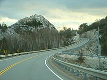
After crossing the North Channel, Highway 6 climbs through the La Cloche Mountains near Whitefish Falls (see image). Eventually, it arrives in Baldwin, north of Espanola, ending at Trans-Canada Highway 17 in the community of McKerrow, 117 km from South Baymouth.
History
Planning for the original section of what would become Highway 6 began in 1837, when Charles Rankin was hired to survey a line between Guelph and a new town site on the southern shore of Georgian Bay known as Sydenham (renamed to Owen Sound in 1851). A new line was surveyed in 1840 by John McDonald, and construction along this route began. Around the same time, the Van Norman Company constructed a plank road between Port Dover and Hamilton known as both the Hamilton Plank Road and the Dover Road.[9][10] By 1848, the 119 km (74 mi) Garafraxa Road between Guelph and Sydenham was completed.[11][12] The remaining section between Hamilton and Guelph, known as the Brock Road, was constructed between 1848 and 1850 over the Guelph and Dundas wagon road.[13] The wagon road, merely a trail through the forest, was cleared by the Canada Company in the 1820s.[14]
From its official opening in 1920 until March 31, 1997, Highway 6's southern terminus was the Highway 24 junction just west of Port Dover. On April 1, 1997, the Ontario government downloaded many highways in the province, among which was the portion of Highway 6 from the Highway 24 junction to St. Patrick Street. This 7.7 km (4.8 mi) section, which was downloaded to the local county government, is now known as Norfolk County Highway 6. After October 15, 1997, Highway 6 was routed via Upper James Street, York Boulevard, Main Street, and James Street South. This section was downloaded back to the Hamilton government when the new Highway 6 By-Pass, a 2-lane freeway for the most part, was completed (see below).
Prior to 1982, Highway 6 on Manitoulin Island and northward towards Espanola was known as Highway 68, but in that year it was redesignated as part of Highway 6 despite the discontinuous route (though some would consider the Tobermorry ferry route part of the highway corridor). During the winter months, the highway is discontinuous. Apart from Highway 407 and the international crossing toll bridges, it is the only provincial highway that requires a toll to travel any part of its length.
See also
- List of Ontario provincial highways
References
- ^ Ministry of Transportation of Ontario, 2004 Annual Average Daily Traffic
- ^ Peter Heiler Ltd. Road Atlas – Canada, United States, and Mexico (Map) (2008 ed.). p. 17, 19, section B6–G7, G8–K8, L9, M10–R11.
- ^ "Highway 6 Information for Norfolk County to City of Hamilton". Ontario King's Highways. http://www.onthighways.com/highway_6_page_1.htm. Retrieved 2007-07-03.
- ^ a b "Highway 6 - Images Highway 24 to Highway 403". Ontario King's Highways. http://www.onthighways.com/hwy_3-9_images/Hwy6_p1_images.htm. Retrieved 2007-10-11.
- ^ "Google Map of Highway 6 at Owen Sound.". Google Maps. http://maps.google.ca/maps?f=q&hl=en&geocode=&q=HWY-6,+Ontario,+Canada&sll=49.891235,-97.15369&sspn=25.897616,58.623047&ie=UTF8&cd=5&mpnum=0&ll=44.568336,-80.940228&spn=0.055766,0.114498&t=h&z=13&om=1. Retrieved 2007-07-20.
- ^ "Fares of the Chi-Cheemaun Ferry". MS Chi-Cheemaun Ferry. http://www.ontarioferries.com/chi/english/schedule_fares.html#fares. Retrieved 2007-06-30.
- ^ "Schedule of the Chi-Cheemaun Ferry". MS Chi-Cheemaun Ferry. http://www.ontarioferries.com/chi/english/schedule_fares.html#may. Retrieved 2007-06-30.
- ^ "Images of Highway 6 at Little Current". Ontario King's Highways. http://www.onthighways.com/hwy_3-9_images/Hwy6_p3_images.htm. Retrieved 2007-07-03.
- ^ Ontario Historical Society (1919). Ontario History. Kraus Reprint. p. 95. http://books.google.ca/books?ei=aPe8TLegCZ2fnwfL9-CJDg&ct=result&id=mgcVAAAAYAAJ&dq=%22Plank+and+Gravel+Road%22+Ontario&q=%22Plank+and+Gravel+Road%22#search_anchor. Retrieved October 18, 2010.
- ^ http://books.google.ca/books?id=4-NLAAAAYAAJ&dq=Guelph%20%22The%20Brock%20Road%22&pg=PA7#v=onepage&q=Guelph%20%22The%20Brock%20Road%22&f=false
- ^ http://books.google.ca/books?id=pkp1MNny-c8C&lpg=PA62&dq=%22Highway%206%22%20Ontario&pg=PA62#v=onepage&q=Road&f=false
- ^ http://books.google.ca/books?id=W2IhCb2yqJ4C&lpg=PA19&dq=%22Garafraxa%20Road%22&pg=PA19#v=onepage&q=%22Garafraxa%20Road%22&f=false
- ^ http://books.google.ca/books?ei=59a9TJzuM4qr8AbSovm5Bw&ct=result&id=zEcUAQAAIAAJ&dq=Guelph+%22The+Brock+Road%22&q=%22The+Brock+Road%22#search_anchor
- ^ http://books.google.ca/books?id=aub74tZnFzIC&pg=PA19&dq=Guelph+Dundas+Wagon&hl=en&ei=_9W9TMj9KMH38Abb3LH9Bg&sa=X&oi=book_result&ct=result&resnum=1&ved=0CDEQ6AEwAA#v=onepage&q=Guelph%20Dundas%20Wagon&f=false
External links
The King's Highways of Ontario Current highwaysFormer highways- 2A
- 2B
- 2S
- 3B
- 4A
- 5A
- 7B
- 8A
- 12B
- 14
- 15A
- 18
- 18A
- 22
- 24A
- 25
- 27
- 29
- 30
- 31
- 32
- 35A
- 35B
- 36
- 38
- 39
- 40B
- 42
- 43
- 44
- 45
- 46
- 47
- 48B
- 50
- 51
- 52
- 53
- 54
- 55
- 56
- 57
- 59
- 68
- 70
- 73
- 74
- 75
- 76
- 78
- 79
- 80
- 81
- 82
- 83
- 84
- 86
- 87
- 88
- 90
- 91
- 92
- 95
- 96
- 97
- 98
- 99
- 100
- 103
- 104
- 106
- 107
- 109
- 110
- 111
- 114
- 116
- 117
- 119
- 120
- 121
- 122
- 123
- 126
- 128
- 131
- 133
- 134
- 135
- 136
- 169
- 400A
- 401A
County roads in Ontario · Ontario numbered highways · Expressways and 400-series highways · King's Highways · Secondary highways · Tertiary and 7000-series highways · List of Ontario provincial highways · List of former provincial highways in Ontario · Highways in Ontario · List of Ontario expressways · Trans-Canada Highway · Connecting Link · Emergency Detour RouteCategories:- Ontario provincial highways
- Roads in Hamilton, Ontario


Wikimedia Foundation. 2010.