- Wellington County, Ontario
Infobox Settlement
name =
official_name = Wellington County
other_name =
native_name =
nickname =
settlement_type =County
total_type =
motto =
imagesize =
image_caption =
flag_size =
image_
seal_size =
image_shield =
shield_size =
image_blank_emblem =
blank_emblem_type =
blank_emblem_size =
imagesize =
image_caption =
flag_size =
image_
seal_size =
image_shield =
shield_size =
image_blank_emblem =
blank_emblem_type =
blank_emblem_size =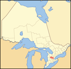
mapsize = 300px
map_caption = Location of Wellington County
mapsize1 =
map_caption1 =
image_dot_
dot_mapsize =
dot_map_caption =
dot_x = |dot_y =
pushpin_
pushpin_label_position =
pushpin_map_caption =
pushpin_mapsize =
subdivision_type = Country
subdivision_name = CAN
subdivision_type1 = Province
subdivision_name1 = ONT
subdivision_type2 =
subdivision_name2 =
seat_type =Administration seat
seat =Guelph
parts_type =Municipalities
parts_style =
parts =
p1 = Township of Centre Wellington
p2 =Town of Erin
p3=Township of Guelph/Eramosa
p4=Township of Puslinch
p5= Township of Mapleton
p6=Town of Minto
p7= Township of Wellington North
government_footnotes =
government_type =
leader_title =
leader_name =
leader_title1 =
leader_name1 =
established_title =
established_date =
area_magnitude =
unit_pref =Imperial
area_footnotes =cite web |url=http://www12.statcan.ca/english/census06/data/profiles/community/Details/Page.cfm?Lang=E&Geo1=CD&Code1=3523&Geo2=PR&Code2=35&Data=Count&SearchText=Wellington&SearchType=Begins&SearchPR=35&B1=All&Custom= |title=Community highlights for Wellington |accessdate=2007-12-28 |date= |work= |publisher=]
area_total_km2 =
area_land_km2 =2656.66
area_water_km2 =
area_total_sq_mi =
area_land_sq_mi =1025.74
area_water_sq_mi =
area_water_percent =
elevation_footnotes =
elevation_m =
elevation_ft =
elevation_max_m =
elevation_max_ft =
elevation_min_m =
elevation_min_ft =
population_as_of =2006
population_footnotes =
population_note =
population_total = 200425
population_density_km2 =75.4
population_density_sq_mi =195.4
timezone = EST
utc_offset = -5
timezone_DST = EDT
utc_offset_DST = -4
coor_type =
latd= |latm= |lats= |latNS=
longd= |longm= |longs= |longEW=
postal_code_type =
postal_code =
area_code =
website = [http://www.county.wellington.on.ca/ www.county.wellington.on.ca/]
footnotes =Wellington County (population 200,425) is a
county located inSouthwestern Ontario ,Canada . Its administration centre is located in Guelph and its ratepayers live in seven municipalities that the county comprises. Wellington County does not include the City of Guelph, which is a separated municipality and is not technically a part of the county; Guelph is included in the Wellingtoncensus division , however.The county's geographical area covers convert|1025.74|sqmi|km2|2. Wellington County is predominantly rural in nature, though many of its residents commute to Guelph, Kitchener, Brampton, Mississauga, and even
Toronto .Municipalities
* Township of Centre Wellington
* Town of Erin
* Township of Guelph/Eramosa
* Township of Mapleton
* Town of Minto
* Township of Puslinch
* Township of Wellington NorthHistory
In 1837 by Act of Parliament the new District of Wellington was formed and a court house and jail in the town of Guelph were authorized. In 1840 the county officials received their commissions. The District Council of the County of Wellington was formed and consisted of eighteen municipalities as follows: the town of Guelph, the villages of Fergus, Elora, Mount Forest and Orangeville, and the following historic townships ["The Orangeville Banner", March 8, 1951 and, Source: "Province of Ontario -- A History 1615 to 1927" by Jesse Edgar Middleton & Fred Landon, copyright 1927, Dominion Publishing Company, Toronto Page 1235] :
* Arthur, area 64,494 acres (261 km²). Opened in 1835, it was named afterArthur Wellesley, 1st Duke of Wellington . Community centres: Arthur, Kenilworth and Mount Forest.
* Eramosa, area 44,482 acres (180 km²). Opened in 1821. The name is an attempt to render in English the Indian "un-ne-mo-sa", which means dog. Community centres: Eden Mills, Rockwood, Speedside and Eramosa.
* Erin, area 70,557 acres (286 km²), opened in 1820, Community centres: Erin, Hillsburg, Mimosa
* West Garafraxa, area 46,950 acres (190 km²), Opened in 1821. Name is believed to be from an Indian word meaning "the place of panthers." Community centres: Fergus (only partially in the township), Reading, Metz and Garafraxa
* Guelph Township, area 35,543 acres (144 km²). Opened on April 23, 1827 by John Galt on behalf of theCanada Company .
* West Luther, area 49,830 acres (202 km²). Opened in 1821 and named after the leader of the Reformation in Germany,Martin Luther . It was said that the surveyor, a Roman Catholic, having been embarrassed by the endless swamps he had encountered declared that this was "the meanest piece of country he had seen" and named it Luther for that reason. Community centres: Monck, Stonywood, Damascus and Arthur.
* Maryborough, area 56,728 acres (230 km²). Opened in 1840 and named after a brother of the Duke of Wellington, Baron Maryborough. Community centres: Drayton, Moorefield and Rothsay.
* Minto, area 69,927 acres (283 km²) Opened in 1840 and named after the Earl of Minto, a famous pro-consul in India. Settled mainly between 1861 to 1875. Comummnity centres: Harriston, Palmerston, and Clifford.
* Nichol, area 26,996 acres (109 km²) One of the townships leased byJoseph Brant under power of attorney for the Indians of th Grand River region. The Township was granted to Hon. Thomas Clark on a lease of 999 years for 3,564, but the contract was modified by the Crown. The Township was opened for settlement in 1822. Named in honour of Col Robert Nichol of Norfolk who distinguished himself in theWar of 1812 and latter in political battles. Community centres: Elora, Fergus, Salem and Barnet.
* Peel, area 74,525 acres (302 km²), Opened in 1835 and named in honour of SirRobert Peel . Settled mainly between 1850 to 1853. Community centres: Drayton, Glenallan, Goldstone and Alma.
* Pilkington, area 28,983 acres (117 km²) named in honour of Lieutenant Robert Pilkington (later General Pilkington) who accompaniedJohn Graves Simcoe to Upper Canada. Pilkington acquired 20,000 acres (80 km²) of land. Community Centre: Elora in Nichol Township.
* Puslinch: area 58,291 acres (236 km²) Named from Pushlinch in Devonshire, Lady Colborne's home before her marriage. .References
External links
* [http://www.county.wellington.on.ca/ Wellington County website]
* [http://www.wellingtonguelph.ca/ Wellington Guelph Community Portal]
* [http://www.visitguelphwellington.ca/ Wellington County Tourism]
Wikimedia Foundation. 2010.