- Bruce County, Ontario
Infobox Settlement
name =
official_name =Bruce County
other_name =
native_name =
nickname =
settlement_type =County
total_type =
motto =
imagesize =
image_caption =
flag_size =
image_
seal_size =
image_shield =
shield_size =
image_blank_emblem =
blank_emblem_type =
blank_emblem_size =
imagesize =
image_caption =
flag_size =
image_
seal_size =
image_shield =
shield_size =
image_blank_emblem =
blank_emblem_type =
blank_emblem_size =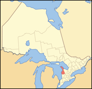
mapsize = 300px
map_caption = Location of Bruce County In Ontario
mapsize1 =
map_caption1 =
image_dot_
dot_mapsize =
dot_map_caption =
dot_x = |dot_y =
pushpin_
pushpin_label_position =
pushpin_map_caption =
pushpin_mapsize =
subdivision_type = Country
subdivision_name = CAN
subdivision_type1 = Province
subdivision_name1 = ONT
subdivision_type2 =
subdivision_name2 =
seat_type =County seat
seat =Walkerton, Ontario
parts_type =Settlements
parts_style =
parts =
p1 = Towns
p2 = Saugeen Shores
p3=South Bruce Peninsula
p4=
p5=Township
p6=Huron-Kinloss
p7=
p8=Municipalities
p9=Arran-Elderslie
p10=Brockton
p11 =Kincardine
p12= Northern Bruce Peninsula
p13=South Bruce
p14=
p15=Indian Reserves
p16=Neyaashiinigmiing
p17=Saugeen 29
government_footnotes =
government_type =
leader_title =
leader_name =
leader_title1 =
leader_name1 =
established_title =
established_date =
area_magnitude =
unit_pref =Imperial
area_footnotes =
area_total_km2 =4155.53
area_land_km2 =
area_water_km2 =
area_total_sq_mi =
area_land_sq_mi =
area_water_sq_mi =
area_water_percent =
elevation_footnotes =
elevation_m =
elevation_ft =
elevation_max_m =
elevation_max_ft =
elevation_min_m =
elevation_min_ft =
population_as_of =2006
population_footnotes =
population_note =
population_total =65349
population_density_km2 =16
population_density_sq_mi =41.4
timezone = EST
utc_offset = -5
timezone_DST = EDT
utc_offset_DST = -4
coor_type =
latd= |latm= |lats= |latNS=
longd= |longm= |longs= |longEW=
postal_code_type =
postal_code =
area_code =
website =
footnotes =
blank_name =Primary Highways
blank_info =21, 9, and 6
blank1_name =
blank1_info = Bruce County is acounty in westernOntario ,Canada , and includes theBruce Peninsula . As of 2006, thepopulation was 65,349. Thearea was convert|4155.53|km2|sqmi|0. Thecounty seat isWalkerton, Ontario . It is located at coord|44|30|N|81|15|W|region:CA-ON|display=inline,title.The name of the county is linked to the
Bruce Trail and theBruce Peninsula , which the trail runs through. Officially, Bruce County is named for James Bruce, 8th Earl of Elgin and 12th Earl of Kincardine, sixthGovernor General of the Province of Canada .The county contains the
Bruce Peninsula National Park . Notable towns include Tobermory andWiarton , home of the weather predictinggroundhog Wiarton Willie .Communities
*Towns
**Saugeen Shores
**South Bruce Peninsula*Township
**Huron-Kinloss*Municipalities
**Arran-Elderslie
**Brockton
**Kincardine
**Northern Bruce Peninsula
**South Bruce*Indian Reserves
**Neyaashiinigmiing
**Saugeen 29Historic Townships
*Albemarle (Hope Bay, McIver, Colpoy's Bay, Mar, Red Bay) now in South Bruce Peninsula
*Amabel (Wiarton, Oliphant, Sauble Falls, Skipness, Park Head, Allenford) now in South Bruce Peninsula
*Arran (Elsinore, Tara, Invermay, Burgoyne) now in Arran-Elderslie
*Brant (Walkerton, Maple Hill, Dunkeld, Eden Grove, Vesta, Elmwood) now in Brockton
*Bruce (Tiverton, Underwood, Inverhuron) now in the Municipality of Kincardine
*Carrick (Formosa, Ambleside, Mildmay, Deemerton, Carlsruhe) now in South Bruce
*Culross (Teeswater) now in South Bruce
*Eastnor (Spry, Lion's Head, Hopeness, Pike Bay) now in Northern Bruce Peninsula
*Elderslie (Paisley, Chesley) now in Arran-Elderslie
*Greenock (Riversdale, Greenock, Chepstow, Cargill, Pinkerton, Bradley, Lovat) now in Brockton
*Huron (Pine River, Purple Grove, Verdun, Ripley) now in Huron-Kinloss
*Kincardine (Kincardine, Inverhuron, Millarton, Bervie, Armow) now in the Municipality of Kincardine
*Kinloss (Kinloss, Kinlough, Holyrood, Langside, Lucknow) now in Huron-Kinloss
*Lindsay (Cape Chin, Dyer's Bay, Stokes Bay) now in Northern Bruce Peninsula
*Saugeen (Southampton, Port Elgin) now the Town of Saugeen Shores
*St. Edmund's (Tobermory) now in Northern Bruce PeninsulaAttractions
*Algonquin Brewery (South Bruce)
*"Arabia" Shipwreck (Northern Bruce Peninsula)
*"Avalon Voyageur II" Shipwreck (Northern Bruce Peninsula)
*Big Tub Light (Northern Bruce Peninsula)
*Bluewater Summer Festival Theatre (Kincardine)
*Bruce County Museum (Saugeen Shores)
*Bruce Trail
*Bruce Nuclear Generating Station (Kincardine)
*Cabot Head Light and Heritage Museum (Northern Bruce Peninsula)
*"Cascaden" Shipwreck (Northern Bruce Peninsula)
*Cassel's Cove Shipwreck (Northern Bruce Peninsula)
*Chantry Island Light (Saugeen Shores)
*"Charles P. Minch" Shipwreck (Northern Bruce Peninsula)
*"China" Shipwreck (Northern Bruce Peninsula)
*Cove Island Point (Northern Bruce Peninsula)
*Devil's Monument (Northern Bruce Peninsula)
*Flowerpot Island Light (Northern Bruce Peninsula)
*Flowerpot Rocks (Northern Bruce Peninsula)
*"Forest City" Shipwreck (Northern Bruce Peninsula)
*"Gargantua" Shipwreck (Northern Bruce Peninsula)
*Gat Point Shipwreck (Northern Bruce Peninsula)
*Gillies Hill Ghost Town (Arran-Elderslie)
*Hanover/Saugeen Airport (Brockton)
*Indian Head Cove Caves and Grotto (Northern Bruce Peninsula)
*"James C. King" Shipwreck (Northern Bruce Peninsula)
*"John Walters" Shipwreck (Northern Bruce Peninsula)
*Kincardine Airport (Kincardine)
*Kincardine Rear Range Light and Museum (Kincardine)
*"Lady Dufferin" Shipwreck (Northern Bruce Peninsula)
*Larkwhistle Garden (Northern Bruce Peninsula)
*Malcolm Ghost Town (Brockton)
*Marble bedded lake (Northern Bruce Peninsula)
*"Marion L. Breck" Shipwreck (Northern Bruce Peninsula)
*"M.S.Chi-Cheemaun " (Northern Bruce Peninsula)
*"Newaygo" Shipwreck (Northern Bruce Peninsula)
*"Philo Scoville" Shipwreck (Northern Bruce Peninsula)
*Point Clark Lighthouse Museum (Huron-Kinloss)
*Point Clark Lighthouse National Historic Site (Huron-Kinloss)
*"Points West" Shipwreck (Northern Bruce Peninsula)
*Port Elgin Airport (Saugeen Shores)
*Sauble Beach Amusements (South Bruce)
*Sauble Speedway (South Bruce)
*Saugeen Amphitheatre (Saugeen 29)
*Saugeen Trail (Saugeen Shores)
*Sweetwater Cruise (Northern Bruce Peninsula)
*The Peninsula and St. Edmunds Museum (Northern Bruce Peninsula)
*The Scenic Caves (Northern Bruce Peninsula)
*Tobermory Airport (Northern Bruce Peninsila)
*Treasure Chest Museum (Arran-Elderslie)
*Wiarton Willie (South Bruce)
*"W.L. Wetmore" Shipwreck (Northern Bruce Peninsula)Protected Areas
*Arran Lake Conservation Area
*Black Creek Provincial Park
*Brucedale Conservation Area
*Bruce Peninsula National Park
**Cyprus Lake
*Cabot Head Provincial Nature Reserve
*Chantry Island National Migratory Bird Sanctuary
*Denny's Dam Conservation Area
*Fathom Five National Marine Park
**Flowerpot Island
*Glammis Bog Conservation Area
*Greenoch Swamp Wetland Complex Conservation Area
*Hardwood Hills Conservation Area
*Hope Bay Forest Provincial Nature Reserve
*Inverhuron Provincial Park
*Johnston Harbour Pine Tree Point Provincial Nature Reserve
*Lion's Head Provincial Nature Reserve
*Little Cove Provincial Nature Reserve
*Lockerby Conservation Area
*MacGregor Point Provincial Park
**Algonquin
**Huron
**Nipissing
*McBeath Conservation Area
*McMaster Island Provincial Nature Reserve
*Rankin Provincial Resource Management Area
*Sauble Falls Provincial Park
*Saugeen Bluffs Conservation Area
*Smoky Head - White Bluff Provincial Nature Reserve
*Spirit Rock Conservation Area
*Stoney Island Conservation Area
*Tara Conservation AreaHighways
Highways in Bruce include:
*Primary Highways: 21, 9, and 6Demographics
"(
Statistics Canada , 2006)"
*Population change (2001-2006): 2.3
*Dwellings: 38,432
*Density: PD km2 to mi2|16|abbr=yes
*National rank in terms of population: 91
*Provincial rank in terms of population: 36People
*96%White
*3%Aboriginal
*1%Visible Minority urrounding Counties
*
Huron County, Ontario
*Grey County, Ontario
*Wellington County, Ontario
*Manitoulin District, Ontario ee also
*
List of counties and districts of Canada
*Bruce Peninsula
*Sauble Beach References
External links
* [http://www12.statcan.ca/english/census06/data/profiles/community/Details/Page.cfm?Lang=E&Geo1=CD&Code1=3541&Geo2=PR&Code2=35&Data=Count&SearchText=bruce&SearchType=Begins&SearchPR=35&B1=All&Custom= Statistics Canada 2006 Community Profile - Bruce County, Ontario]
* [http://www.brucecounty.on.ca Bruce County Official Website]
* [http://ontarioplaques.com/Locations/Location_DirectoryBruce.html Ontario Plaques in the County of Bruce]
Wikimedia Foundation. 2010.