- Erin, Ontario
-
Town of Erin — Town — 
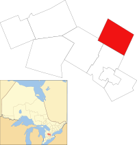
Coat of armsLocation of Erin within Wellington County Coordinates: 43°46′N 80°04′W / 43.767°N 80.067°WCoordinates: 43°46′N 80°04′W / 43.767°N 80.067°W Country  Canada
Province  Ontario
County Wellington Established 1820 Amalgamated 1997 Government – Mayor Lou Maieron – Governing Body Town of Erin Council – MP Mike Chong (Con) – MPP Ted Arnott (PC) Area[1] – Total 296.98 km2 (114.7 sq mi) Population (2006)[1] – Total 11,148 – Density 37.5/km2 (97.1/sq mi) Time zone EST (UTC-5) – Summer (DST) EDT (UTC-4) Postal code span N0B Area code(s) 519 Website www.erin.ca Erin (population 11,000) is a town in Wellington County, approximately 80 kilometres northwest of Toronto, Ontario, Canada. Erin is an amalgamated town, composed of the former Villages of Erin and Hillsburgh, and the hamlets of Ballinafad, Brisbane, Cedar Valley, Crewson's Corners, and Orton, as well as the former Township of Erin.
Erin is primarily a rural community but, while farming is still an important activity in the town, most of its population works in the nearby cities of Brampton, Mississauga, Guelph, and even Toronto. The town's new industrial park is attracting a number of new industries, due to its cheaper tax rate, accessibility to transportation, and its location within the "Technology Triangle," a series of high-tech driven cities including nearby Kitchener, Waterloo, and Cambridge.
Contents
Communities
In addition to the primary settlement of Erin, the town also includes the smaller communities of Ballinafad, Binkham, Brisbane, Cedar Valley, Churchill, Coningsby, Hillsburgh, Mimosa and Ospringe.
Demographics
Census Population Erin (village) 1871 600 1921 479 1931 451 1941 499 1951 650 1961 1,005 1971 1,446 1981 2,313 1991 2,489 1996 2,633 Erin (town) 2001 11,052 2006 11,148 Population trend:[2]
- Population in 2006: 11,148 (2001 to 2006 population change: 0.9 %)
- Population in 2001: 11,052
- Population total in 1996: 10,657
- Erin (township): 8024
- Erin (village): 2633
- Population in 1991:
- Erin (township): 7561
- Erin (village): 2489
Private dwellings occupied by usual residents: 3808 (total dwellings: 3960)
Mother tongue:[1]
- English as first language: 91.4 %
- French as first language: 1.1 %
- English and French as first language: 0.4 %
- Other as first language: 7.1 %
Culture
Erin revolves around its community centre, called Centre 2000. The building was added to the existing community centre. The facility now includes Erin District High School, 300 seat theatre, large double gym, arena, many community rooms, dentist, physiotherapist, Erin Branch of the Wellington Library, daycare, and many other features. Erin Village Alliance Church meets in the Gymnasium on Sunday mornings. It shows Erin's commitment to its community working together. Within the walls of Centre 2000 is Erin Cinema, located in the 300 seat theatre. It shows first run movies and Toronto Film Festival Circuit films on weekends and some weekdays. Many celebrated Canadians hail from Erin including successful film and television writer/producer Daniel Vincent Fricker.
Media
The town of Erin has a community radio station CHES-FM. The Erin Advocate is the local newspaper and also publishes a monthly Country Routes to surrounding areas, The weekly paid-circulation paper has 2,500 circulation. it is the only media to report local news.
References
- ^ a b c "Erin community profile". 2006 Census data. Statistics Canada. http://www12.statcan.ca/census-recensement/2006/dp-pd/prof/92-591/details/page.cfm?Lang=E&Geo1=CSD&Code1=3523017&Geo2=PR&Code2=35&Data=Count&SearchText=Erin&SearchType=Begins&SearchPR=01&B1=All&Custom=. Retrieved 2011-01-17.
- ^ Statistics Canada: 1996, 2001, 2006 census
External links

East Garafraxa Caledon 
Centre Wellington 
 Erin
Erin 

Guelph/Eramosa Halton Hills Cities Guelph 1Towns Erin • MintoTownships See also: Communities in Wellington County • Census divisions of Ontario
1 Separated municipality but remains a census subdivision of the countyCategories:- Municipalities in Wellington County, Ontario
- Towns in Ontario
- Western Ontario geography stubs
Wikimedia Foundation. 2010.

