- Minto, Ontario
-
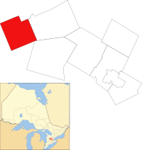
Minto — Town — Main Street, Harriston Motto: "Resolutely To The Goal" Location of Minto within Wellington County Coordinates: 43°55′N 80°52′W / 43.917°N 80.867°WCoordinates: 43°55′N 80°52′W / 43.917°N 80.867°W Country  Canada
Province  Ontario
County Wellington Settled Formed 1999 Government - Mayor George Bridge - Deputy Mayor Terry Fisk - Federal riding Perth—Wellington - Prov. riding Perth—Wellington Area[1] - Land 300.37 km2 (116 sq mi) Elevation 334 m (1,096 ft) Population (2006)[1] - Total 8,504 - Density 28.3/km2 (73.3/sq mi) Time zone EST (UTC-5) - Summer (DST) EDT (UTC-4) Postal code N0G 2P0
N0G 1Z0
N0G 1M0Area code(s) 519 and 226 Website www.town.minto.on.ca Minto is a town in midwestern Ontario, Canada, on the Maitland River in Wellington County. Minto is the eastern terminus of Highway 9. It is named for Gilbert Elliot-Murray-Kynynmound, 4th Earl of Minto; 8th Governor General of Canada.
The Town of Minto was formed in 1999 through the amalgamation of the Township of Minto, the Towns of Harriston and Palmerston, along with the Village of Clifford.
Contents
Demographics
Population trend:[2]
- Population in 2006: 8504 (2001 to 2006 population change: 4.2 %)
- Population in 2001: 8164
- Population total in 1996: 7854
- Clifford (village): 775
- Harriston (town): 2008
- Minto (township): 2603
- Palmerston (town): 2468
- Population in 1991:
- Clifford (village): 784
- Harriston (town): 1995
- Minto (township): 2454
- Palmerston (town): 2313
Sports
- Palmerston 81's SR. A hockey team playing in the Western Ontario Athletic Association.
- Harriston Mercurys fastball team—two time ASC II World Champions
Education
Minto's schools are governed by the Upper Grand District School Board.
- Palmerston Public School (grades JK–8) – mascot: Panda
- Minto Clifford Central Public School (grades JK–8) – mascot: Bee
- Norwell District Secondary School (grades 9–12) – mascot: Redmen
Communities
- Clifford
- Cotswold
- Drew
- Fultons
- Glenlee
- Harriston
- Harriston Junction
- Minto
- Palmerston
- White's Junction — the rail junction for the intersection of White's Road near the town of Minto. The rail has since been removed by the Ontario Government, leaving a clear path which is known as White's Junction Trail.
References
- ^ a b "Minto community profile". 2006 Census data. Statistics Canada. http://www12.statcan.gc.ca/census-recensement/2006/dp-pd/prof/92-591/details/page.cfm?Lang=E&Geo1=CSD&Code1=3523043&Geo2=PR&Code2=35&Data=Count&SearchText=Minto&SearchType=Begins&SearchPR=01&B1=All&Custom=. Retrieved 2011-01-28.
- ^ Statistics Canada: 1996, 2001, 2006 census
External links

South Bruce West Grey 
Howick 
Wellington North  Minto
Minto 

North Perth Mapleton Cities Guelph 1Towns Erin • MintoTownships See also: Communities in Wellington County • Census divisions of Ontario
1 Separated municipality but remains a census subdivision of the countyCategories:- Towns in Ontario
- Municipalities in Wellington County, Ontario
- Western Ontario geography stubs
Wikimedia Foundation. 2010.


