- Ontario Highway 102
-
For the former Highway 102 in Dundas, Ontario, see Cootes Drive.
Highway 102
Route information Maintained by the Ministry of Transportation of Ontario Length: 33.0 km[1] (20.5 mi) Existed: 1972 – present Major junctions West end: 
 Highway 11 / Highway 17 at Sistonens Corners
 Highway 589 – Lappe
East end: Highway 11 / Highway 17 in Thunder BayHighway system Ontario provincial highways
400-series • Former←  Highway 101
Highway 105  →
→King's Highway 102, commonly referred to as Highway 102, formerly as Highway 11A and Highway 17A and historically as the Dawson Road, is a provincially maintained highway in the Canadian province of Ontario, serving as a northern bypass to the city of Thunder Bay.
Both the western and eastern termini of Highway 102 are with the concurrency of Highway 11 and Highway 17; in the rural community of Sistonens Corners to the west and in Thunder Bay to the east.
Contents
Route description
Highway 102 passes through terrain typical of northern Ontario highways, including thick boreal forest and muskeg. On an eastward journey, the surroundings quickly change from isolated muskeg-ridden foothills to urban development as the highway enters Thunder Bay from the north. Highway 102 provides a shortcut over the Trans-Canada Highway to the south, as such it is frequented by transport trucks, despite local protest.
Highway 102 begins at Sistonens Corners, immediately south of a Canadian National Railway (CN) overpass, along Highway 11 and Highway 17. A truck stop sits to the west of the intersection. From there, the two-lane road travels east through rolling hills, with muskeg dotting the valleys between the hills. It parallels roughly 1 kilometre (0.62 mi) to the south of the Shebandowan River for 4.5 kilometres (2.8 mi) before crossing both the CN and Canadian Pacific Railway tracks as well as the Kaministiquia River. The highway meets Silver Falls Road, which proceeds north to Silver Falls Provincial Park. The terrain becomes gentler as the route passes several houses while travelling alongside a creek. The highway curves as it meets a power transmission line, which it then parallels. It zig-zags southeast, passing alongside Mud Lake and briefly curving back to the east. Curving back to the southeast, the highway serves several houses before crossing into Thunder Bay at Townline Road and curving to the east.[2]
Within the city limits, the density of residences surrounding the highway rapidly increases as the terrain flattens. The highway intersects Mapleward Road, then diverges from the power transmission lines and curves southeast into suburban Thunder Bay. It meets Secondary Highway 589 after passing the Emerald Greens Golf Course. The route then travels through North McIntyre, formerly a separate community which was annexed. It descends through a wide muskeg, after which it is crossed by several power transmission lines. The highway enters urban Thunder Bay immediately thereafter, where it passes to the west of County Fair Mall before ending at an intersection with the Thunder Bay Expressway.[2] The road which carries Highway 102 continues through Thunder Bay as Red River Road, and was once part of the highway.
History
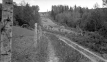 Work on widening the Dawson Road and clearing a new alignment in 1935
Highway 102 was designated by the beginning of 1972, following the route of the former Highway 11A and Highway 17A. Prior to that, the Dawson Road generally followed the present route of the highway.
The history of the Dawson Road began in 1857 when Henry Hind and Simon Dawson were commissioned to survey the territorial claims of the Hudson's Bay Company, as well as to survey a route between Lake Superior and the Red River. A second set of surveys were carried out by Captain John Palliser that same year. The latter recommended avoiding the Kaministiquia River, but ultimately Hind and Dawson's route was chosen. By 1868, the route was blazed between Shebandowan and what would soon be named Prince Arthur's Landing (later changed to Port Arthur). In 1870, the Wolseley Expedition set out from Toronto to end the Red River Rebellion. When Colonel Garnet Wolseley arrived at the present site of Winnipeg, the rebels had fled. However, the expedition resulted in the construction of a road along Dawson's route.[3] It was further improved in 1871.[4]
In 1935, the Department of Northern Development (DND) began construction on a northern bypass of Port Arthur, mostly following the Dawson Road. This road was designated Highway 17A on April 1, 1937, when the DND merged into the Department of Highways.[5][6] In 1959, Highway 120 was renumbered as Highway 11, and a 180-kilometre (110 mi) concurrency with Highway 17 between Shabaqua and Nipigon was created to join the discontinuous segments. As the northern bypass of Port Arthur now formed an alternate route to both Highway 11 and 17, it was codesignated as Highway 11A and 17A.[7]
Between January 1971 and 1972, Highway 11A and Highway 17A were redesignated as Highway 102.[8][9] Work began shortly thereafter to realign several sections of the highway with dangerous curves and steep grades approaching the Kaministiquia River; the highway opened in 1975, featuring a new bridge over the river.[citation needed]
Major intersections
The following table lists the major junctions along Highway 102. The entirety of the highway is located within Thunder Bay District.[2][10]
Location[10] km[1] Destinations Notes Sistonens Corners 0.0 Highway 11 / Highway 17 – ShabaquaKaministiquia 4.9 Silver Falls Road To Silver Falls Provincial Park and Highway 591 Thunder Bay 22.6 Mapleward Road 26.1 End of Thunder Bay connecting link agreement 26.3 Highway 589 (Dog Lake Road) – Lappe32.8 Beginning of Thunder Bay connecting link agreement 33.0 Highway 11 / Highway 17 (Thunder Bay Expressway) – NipigonContinues towards Lake Superior as Red River Road 1.000 mi = 1.609 km; 1.000 km = 0.621 mi References
- Sources
- ^ a b Ministry of Transportation of Ontario (2007). "Annual Average Daily Traffic (AADT) counts". Government of Ontario. http://www.raqsb.mto.gov.on.ca/techpubs/TrafficVolumes.nsf/tvweb?OpenForm&Seq=5. Retrieved February 26, 2010.
- ^ a b c Peter Heiler Ltd (2010). Ontario Back Road Atlas (Map). Cartography by MapArt. p. 107, section H–J8. ISBN 978-1-55198-226-7.
- ^ Bolz 1999, pp. 8–10.
- ^ Wilkins 1998, p. 69.
- ^ Shragge & Bagnato 1984.
- ^ Department of Highways (1938/39). Ontario Official Government Road Map (Map). Section E12–F13.
- ^ Ontario Department of Highways (1960). Ontario Road Map (Map). Cartography by C.P. Robins. Section H13–G14.
- ^ Department of Transportation and Communications (1971). Ontario Road Map (Map). Cartography by Cartography Section. Section H13–G14.
- ^ Ministry of Transportation and Communications (1972). Ontario Road Map (Map). Cartography by Cartography Section. Section H13–G14.
- ^ a b Minutillo, Carmine (2005). Backroad Mapbook Northwestern Ontario. Mussio Ventures. pp. 5–6, 15. ISBN 978-1-897225-05-9.
- Bibliography
- Bolz, J. Arnold (1999). Portage into the Past. University of Minnesota Press. ISBN 0-8166-0919-5. http://books.google.com/books?id=t3eJXBG_fT4C&pg=PA8. Retrieved March 12, 2011.
- Shragge, John; Bagnato, Sharon, eds (1984). From Footpaths to Freeways. Ontario Ministry of Transportation and Communications, Historical Committee. ISBN 0-7743-9388-2.
- Wilkins, Charles Everett (1998). The Circus at the Edge of the Earth. McClelland and Stewart. ISBN 0-771-08847-7. http://books.google.com/books?id=bVHhAAAAMAAJ&pg=PA69. Retrieved March 12, 2011. "...we were headed out Highway 102, which meets the Trans-Canada thirty kilometres to the west. For a stretch outside of Thunder Bay, the 102 parallels the mosquito-ridden, swamp-sodden mudway known as the Old Dawson Road, blazed by surveyors and axemen in 1871 when the new Dominion of Canada commissioned a road to link Prince Arthur's Landing (now part of Thunder Bay) in the east with Manitoba's Red River Settlement (now Winnipeg) in the west."
External links
The King's Highways of Ontario Current highwaysFormer highways- 2A
- 2B
- 2S
- 3B
- 4A
- 5A
- 7B
- 8A
- 12B
- 14
- 15A
- 18
- 18A
- 22
- 24A
- 25
- 27
- 29
- 30
- 31
- 32
- 35A
- 35B
- 36
- 38
- 39
- 40B
- 42
- 43
- 44
- 45
- 46
- 47
- 48B
- 50
- 51
- 52
- 53
- 54
- 55
- 56
- 57
- 59
- 68
- 70
- 73
- 74
- 75
- 76
- 78
- 79
- 80
- 81
- 82
- 83
- 84
- 86
- 87
- 88
- 90
- 91
- 92
- 95
- 96
- 97
- 98
- 99
- 100
- 103
- 104
- 106
- 107
- 109
- 110
- 111
- 114
- 116
- 117
- 119
- 120
- 121
- 122
- 123
- 126
- 128
- 131
- 133
- 134
- 135
- 136
- 169
- 400A
- 401A
County roads in Ontario · Ontario numbered highways · Expressways and 400-series highways · King's Highways · Secondary highways · Tertiary and 7000-series highways · List of Ontario provincial highways · List of former provincial highways in Ontario · Highways in Ontario · List of Ontario expressways · Trans-Canada Highway · Connecting Link · Emergency Detour RouteCategories:- Ontario provincial highways
- Roads in Thunder Bay
- Roads in Thunder Bay District


Wikimedia Foundation. 2010.