- Ontario Highway 140
-
Highway 140
Route information Maintained by the Ministry of Transportation of Ontario Length: 10.9 km[2] (6.8 mi) Existed: October 5, 1972[1] – present Major junctions South end:  Highway 3 – Port Colborne
Highway 58A – Townline Tunnel North end: Main Street – Welland Location Counties: Regional Municipality of Niagara Major cities: Port Colborne, Welland Highway system Ontario provincial highways
400-series • Former←  Highway 138
Highway 141  →
→King's Highway 140, commonly referred to as Highway 140, is a provincially maintained highway in the Canadian province of Ontario. The highway connects Port Colborne near Lake Erie with Highway 406 in Welland, via the Main Street Tunnel. It was constructed in the early 1970s as part of the Welland Bypass project of the Welland Canal, which resulted in the severance of several highways and rail lines. Opened to traffic in late 1972, several months following the tunnel, Highway 140 has remained unchanged since, despite growing calls to resign it as an extension of Highway 406.
Contents
Route description
Highway 140 begins at an intersection with Highway 3 on the eastern edge of Port Colborne. From there, Highway 3 continues east to Fort Erie; to the west it becomes Niagara Regional Road 3.[3] The roadway carrying Highway 140 continues south of Highway 3 as a local road named Elizabeth Street, whereas Highway 140 travels north, to the west of forestland and a quarry. The highway parallels the Welland Canal throughout its length, always within 2 kilometres (1.2 mi) of the waterway.[4][5] Wooden high-tension powerlines parallel the highway until it diverges, curving towards the northeast immediately north of Chippawa Road. It travels diagonally for several kilometres before ascending on an overpass and crossing the former Canadian National Humberstone Subdivision tracks.[6]
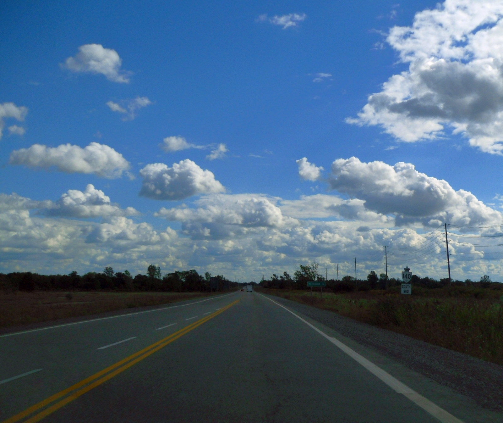
The highway gradually straightens to a north–south alignment as it crosses Highway 58A and a set of railway tracks, both of which travel beneath the nearby Welland Canal to the west. Continuing north, Highway 140 passes over Lyons Creek, which meanders northeast to converge with the Welland River west of the Niagara River.[5] The highway ends approximately 1 kilometre (0.62 mi) north of this point at an intersection with Main Street (Niagara Regional Road 27).[2] Main Street travels beneath the Welland Canal immediately west of Highway 140, providing a connection to Highway 406 on the opposite side.[7] Because of its importance as both a through route past the canal and in linking Highway 140 with Highway 406, East Main Street is maintained the Ministry of Transportation of Ontario (MTO) as Highway 7146.[2]
 Highway 140 immediately south of East Main Street
History
The history of Highway 140 begins in May 1966, when the St. Lawrence Seaway Authority received Federal approval for the Welland Bypass, a 13.4-kilometre (8.3 mi) channel that would serve to bypass the canal through downtown Welland, where several crossings proved to be a hazard for shipping traffic and the shipping traffic an impediment to pedestrian and vehicular traffic. The new channel would be dug out and flooded,[8] providing the opportunity for the construction of cheap cut and cover tunnels beneath the channel. By 1968, construction was underway on a tunnel at East Main Street and at the Port Colborne – Welland townline.[9]
Due to the numerous road disconnections that would take place as a result of the Welland Bypass, a new highway was proposed to link Welland with Port Colborne.[4] One of the severed highways was Highway 58, which then followed Canal Bank Street south from Welland.[10] In late 1970, the Department of Highways tendered contracts for the construction of the new highway on the east side of the bypass. Construction began from the north, reaching as far south as Ramey Road.[11][6]
The section north of Townline Road was completed within a year. Around the same time, the third and final contract was tendered for the section north of Highway 3. On May 20, 1972, the Main Street Tunnel was opened to traffic at a morning ceremony featuring local officials and the Welland Police Association Pipe Band.[12] Highway 140 was opened several months later, without ceremony, on October 5.[1] It has remained unchanged since then, and was not affected by the provincial highway transfers in 1997 and 1998.[13][14]
The various municipalities serviced by Highway 140, as well as Niagara Region, have called for four-laning the route and redesignating it as Highway 406. However, the MTO is committed to extending Highway 406 to Highway 58 southwest of Welland. On April 4, 2006, the MPP for Erie—Lincoln, Tim Hudak, introduced a Private Member's Bill.[15] The Highway 406 to Port Colborne Act passed first reading, but was not brought up for a second reading.[16]
Major intersections
The following table lists the major junctions along Highway 140. The entirety of the highway is located within the Regional Municipality of Niagara.[5][3]
Location[5] km[2] Destinations Notes Port Colborne 0.0 Highway 3 (Main Street)Highway 3 ends immediately west of Highway 140, but resumes west of Port Colborne[3] 0.8 Chippawa Road 5.1 Forkes Road Welland 7.1 Highway 58A West (Netherby Road) Passes beneath the Welland Canal in Townline Tunnel 8.7 Ridge Road 9.8 Buchner Road 10.9 Regional Road 27 (East Main Street) west to  Highway 406 – St. Catharines
Passes beneath Welland Canal in Main Street Tunnel 1.000 mi = 1.609 km; 1.000 km = 0.621 mi References
- ^ a b Canadian Press (October 6, 1972). "Highway 140 Opens". Globe and Mail (Toronto) 129 (38,324): p. 5. "Highway 140, a new six-mile highway running along the east side of the Welland Canal between [Welland] and Port Colborne, was opened Yesterday."
- ^ a b c d Ministry of Transportation of Ontario (2004). "Annual Average Daily Traffic (AADT) counts". Government of Ontario. http://www.raqsb.mto.gov.on.ca/techpubs/TrafficVolumes.nsf/tvweb?OpenForm&Seq=5. Retrieved February 9, 2011.
- ^ a b c Regional Municipality of Niagara (February 2009) (PDF). Regional Road Map (Map). Cartography by Regional Municipality of Niagara. http://www.niagararegion.ca/exploring/pdf/regional-niagara.pdf. Retrieved February 23, 2011.
- ^ a b Annual Report. St. Lawrence Seaway Authority. 1972. p. 46. http://books.google.ca/books?id=OlH0AAAAMAAJ&q=Highway+%22No+140%22+%22Welland%22&dq=Highway+%22No+140%22+%22Welland%22&hl=en&ei=PLhlTanuDJDA8QOO4LClBg&sa=X&oi=book_result&ct=result&resnum=2&sqi=2&ved=0CDIQ6AEwAQ. Retrieved February 23, 2011.
- ^ a b c d Peter Heiler (2010). Ontario Back Road Atlas (Map). Cartography by MapArt. p. 19, section T–U34. ISBN 978-1-55198-226-7.
- ^ a b Highway Construction Program: King's and Secondary Highways (Report). Ontario Department Of Highways. April 1, 1972. p. xviii.
- ^ "Highway #140 Industrial Area". City of Port Colborne. http://www.portcolborne.com/page/Highway_140_Industrial_Area. Retrieved February 24, 2011.
- ^ "The Welland Canal Section of the St. Lawrence Seaway" (PDF). The St. Lawrence Seaway Management Corporation. March 2003. p. 8–9. http://www.greatlakes-seaway.com/en/pdf/welland.pdf. Retrieved February 24, 2011.
- ^ Department of Highways (March 19, 1968). "Welland Canal Tunnel Projects". http://localhistory.welland.library.on.ca/clipping/source/fourth/7018.jpg. Retrieved February 24, 2010.
- ^ Jackson, John N. (1997). The Welland Canals and Their Communities: Engineering, Industrial, and Urban Transformation. University of Toronto Press. pp. 375. ISBN 0-8020-0933-6. http://books.google.ca/books?id=o-sI64yldu4C&pg=PA375&dq=%22Highway+140%22+%22Port+Colborne%22+-wikipedia&hl=en&ei=-7dlTdAhzLW2B6en5MsG&sa=X&oi=book_result&ct=result&resnum=1&ved=0CCgQ6AEwAA#v=onepage&q=%22Highway%20140%22%20%22Port%20Colborne%22%20-wikipedia&f=false. Retrieved February 23, 2011. "East of the By-Pass, provincial Highway 140 opened in 1972 to link Welland and Port Colborne along the side of the new channel. It replaced Canal Bank Street..."
- ^ Proceedings of the 1971 Convention. Roads and Transportation Association of Canada. 1971. p. 19. http://books.google.ca/books?id=MLw0p9AJNBQC&q=%22Highway+140%22+%22Port+Colborne%22+-wikipedia&dq=%22Highway+140%22+%22Port+Colborne%22+-wikipedia&hl=en&ei=-7dlTdAhzLW2B6en5MsG&sa=X&oi=book_result&ct=result&resnum=4&ved=0CDUQ6AEwAw. Retrieved February 23, 2011. "West of the relocated Welland Canal in the Port Colborne – Welland area a new six-mile highway is under construction. Known as Highway 140 this new road will connect Highway 3 with Highway 58 at Welland via the new East Main Street Traffic Tunnel. Five miles of the new road are now under construction under two contracts awarded in the latter part of 1970. A contract for the one-mile section north of Highway 3 is scheduled for award later this year."
- ^ "Tunnel Opening". Niagara Falls Review (Sun Media). May 20, 1972. http://localhistory.welland.library.on.ca/clipping/source/tunnels/15001.jpg. Retrieved February 24, 2010.
- ^ Department of Transportation and Communications (1972). Ontario Road Map (Map). Cartography by Photogammetry Office. Section N23.
- ^ Ministry of Transportation (2010). Ontario Official Road Map (Map). Cartography by Bryan Simmons, Lori-Anne Martin. Section S26. http://www.mto.gov.on.ca/english/traveller/map/southindexpdf.shtml. Retrieved February , 2010.
- ^ "Hudak Introduces Legislation To Extend Highway 406 To Port Colborne; Bill to designate Highway 140 as part of Highway 406". Tim Hudak. April 4, 2006. Archived from the original on March 12, 2007. http://web.archive.org/web/20070312091021/http://www.timhudakmpp.com/news2.cfm?newsid=466. Retrieved February 25, 2011.
- ^ Bill 87, Highway 406 to Port Colborne Act. Ontario Legislative Assembly. April 4, 2006. http://ontla.on.ca/web/bills/bills_detail.do?locale=en&BillID=398&isCurrent=false&detailPage=bills_detail_the_bill. Retrieved June 15, 2010.
External links
The King's Highways of Ontario Current highwaysFormer highways- 2A
- 2B
- 2S
- 3B
- 4A
- 5A
- 7B
- 8A
- 12B
- 14
- 15A
- 18
- 18A
- 22
- 24A
- 25
- 27
- 29
- 30
- 31
- 32
- 35A
- 35B
- 36
- 38
- 39
- 40B
- 42
- 43
- 44
- 45
- 46
- 47
- 48B
- 50
- 51
- 52
- 53
- 54
- 55
- 56
- 57
- 59
- 68
- 70
- 73
- 74
- 75
- 76
- 78
- 79
- 80
- 81
- 82
- 83
- 84
- 86
- 87
- 88
- 90
- 91
- 92
- 95
- 96
- 97
- 98
- 99
- 100
- 103
- 104
- 106
- 107
- 109
- 110
- 111
- 114
- 116
- 117
- 119
- 120
- 121
- 122
- 123
- 126
- 128
- 131
- 133
- 134
- 135
- 136
- 169
- 400A
- 401A
County roads in Ontario · Ontario numbered highways · Expressways and 400-series highways · King's Highways · Secondary highways · Tertiary and 7000-series highways · List of Ontario provincial highways · List of former provincial highways in Ontario · Highways in Ontario · List of Ontario expressways · Trans-Canada Highway · Connecting Link · Emergency Detour RouteCategories:- Ontario provincial highways

Wikimedia Foundation. 2010.