- Ontario Highway 85
-
Highway 85
Route information Maintained by the Ministry of Transportation of Ontario Length: 9.8 km[1] (6.1 mi) Major junctions South end: Victoria Street North in Kitchener North end: Printery Road near St. Jacobs Highway system Ontario provincial highways
400-series • Former←  Highway 77
Highway 89  →
→ Highway 85 enters Kitchener along the Conestoga Parkway
King's Highway 85, commonly referred to as Highway 85, is a provincially maintained highway in the Canadian province of Ontario. The 10-kilometre (6.2 mi) highway, which is mostly controlled-access, travels through the Regional Municipality of Waterloo along the Conestoga Parkway from its interchange with Highway 7 to immediately north of the Waterloo city limits, where it continues as Regional Road 85 to St. Jacobs.
Prior to completion of the Conestoga Parkway through Waterloo, Highway 85 followed King Street north of Ottawa Street through Kitchener and Waterloo. Within the City of Waterloo, this former alignment is now maintained by the region as Regional Road 15. Within the city of Kitchener, the road is simply known as King Street.
Contents
Route description
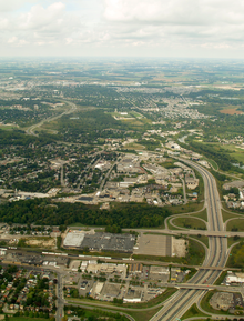 Highway 85 begins at the interchange in the lower-right corner of the image and follows the Conestoga Parkway north into the distance
Highway 85 begins in Kitchener at an interchange between the Conestoga Parkway and Victoria Street. At that interchange, Highway 7 exits the parkway and travels east on Victoria Street towards Guelph.[2] The divided freeway continues north, swerving left and right through suburban Kitchener. It first crosses a Via Rail line and interchanges with Wellington Street, after which it passes alongside the Grand River. After entering the neighbourhood of Bridgeport, which it divides in two, the route curves west, interchanges with Lancaster Street and crosses into Waterloo.[2]
The highway begins to curve north, interchanging with Bridgeport Road. The highway crosses the Conestoga Creek as it interchanges with University Avenue, then gradually curves to the west. After an interchange with King Street, once the original routing of Highway 85, the route curves back to the north and interchanges with Northfield Drive. As it approaches the rural–urban fringe of the tri-city area, the freeway interchanges with King Street a second time. Highway 85 ends at the north end of the ramps from King Street, as does the Conestoga Parkway. The divided freeway ends and the route become Waterloo Regional Road 85, which continues north to St. Jacobs and Elmira.[2]
Major intersections
The following table lists the major junctions along Highway 85. The entirety of the route is located within the Regional Municipality of Waterloo.[2]
Location km[1] Destinations Notes Conestoga Parkway continues south as Highway 7 
0.0 Highway 7 east (Victoria Street) – Guelph, Toronto0.3 Wellington Street 1.8 Lancaster Street 2.7 Regional Road 9 (Bridgeport Road) 4.2 Regional Road 57 (University Avenue) 6.6 Regional Road 15 (King Street) 7.9 Regional Road 50 (Northfield Drive) 9.5 Regional Road 15 (King Street) Highway 85 ends 350 m (1,150 ft) north of King Street interchange  Highway 85 continues as Waterloo Regional Road 85
1.000 mi = 1.609 km; 1.000 km = 0.621 mi References
- ^ a b Ministry of Transportation of Ontario (2007). "Annual Average Daily Traffic (AADT) counts". http://www.raqsb.mto.gov.on.ca/techpubs/TrafficVolumes.nsf/tvweb?OpenForm&Seq=5. Retrieved August 1, 2011.
- ^ a b c d Peter Heiler (2010). Ontario Back Road Atlas (Map). Cartography by MapArt. p. 22, section M22–N23. ISBN 978-1-55198-226-7.
External links
- Highway 85 route
- Waterloo Public Library 1954 image of King and Erb Streets in Waterloo with King's Highway 85 signage
The King's Highways of Ontario Current highwaysFormer highways- 2A
- 2B
- 2S
- 3B
- 4A
- 5A
- 7B
- 8A
- 12B
- 14
- 15A
- 18
- 18A
- 22
- 24A
- 25
- 27
- 29
- 30
- 31
- 32
- 35A
- 35B
- 36
- 38
- 39
- 40B
- 42
- 43
- 44
- 45
- 46
- 47
- 48B
- 50
- 51
- 52
- 53
- 54
- 55
- 56
- 57
- 59
- 68
- 70
- 73
- 74
- 75
- 76
- 78
- 79
- 80
- 81
- 82
- 83
- 84
- 86
- 87
- 88
- 90
- 91
- 92
- 95
- 96
- 97
- 98
- 99
- 100
- 103
- 104
- 106
- 107
- 109
- 110
- 111
- 114
- 116
- 117
- 119
- 120
- 121
- 122
- 123
- 126
- 128
- 131
- 133
- 134
- 135
- 136
- 169
- 400A
- 401A
County roads in Ontario · Ontario numbered highways · Expressways and 400-series highways · King's Highways · Secondary highways · Tertiary and 7000-series highways · List of Ontario provincial highways · List of former provincial highways in Ontario · Highways in Ontario · List of Ontario expressways · Trans-Canada Highway · Connecting Link · Emergency Detour RouteCategories:- Ontario provincial highways
- Roads in Waterloo Region, Ontario


Wikimedia Foundation. 2010.