- Laurentian Divide
-
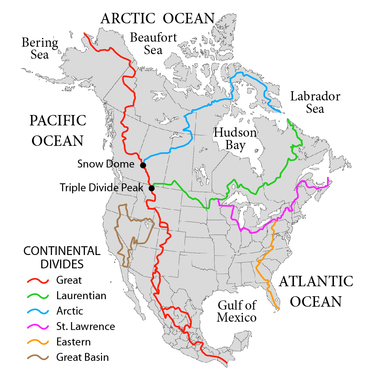 The Laurentian Divide (green) extends from Triple Divide Peak (Montana) to the coast of the Labrador Peninsula at the 60th parallel north, which is the northern limit of the Atlantic Ocean. The northern drainage divide which demarcates the Hudson Bay Watershed (blue) extends to the northern limit of the Hudson Strait.
The Laurentian Divide or Northern Divide is a continental divide dividing the direction of water flow in eastern and southern Canada and the northern Midwestern United States. Water north of the height of land flows to the Arctic Ocean by rivers to Hudson Bay or directly to the Arctic. Water south of the divide makes its way to the Atlantic Ocean by a variety of streams, including the Great Lakes and Saint Lawrence River to the east, and the Mississippi River to the Gulf of Mexico to the south. Some sources consider Hudson Bay to be part of the Atlantic Ocean, not the Arctic, which would make the Laurentian Divide a lesser divide between the seas of one ocean.[1][2]
On the north and east, the divide starts at Cape Chidley on the Labrador Sea in Canada where that sea, part of the Atlantic Ocean, meets Hudson Strait which connects to Hudson Bay in the Arctic Ocean. The divide passes through eastern Canada, dips into the United States, and re-enters Canada before terminating in the Rocky Mountains in the western United States.
In Canada, the height of land forms the border between Quebec and Labrador. It turns west to cross southern Quebec and Ontario; it marks the original northern boundary that both provinces held at the time of Canadian Confederation in 1867, although both have since expanded significantly northward. Waters east and south of the divide flow into the Labrador Sea, the Gulf of St. Lawrence, or the Saint Lawrence River and the Great Lakes which are drained by that river.
The divide crosses into the United States in northeast Minnesota at the Height of Land Portage. Near Hibbing it forms a three-way divide at the Hill of Three Waters (47°28′19″N 92°57′56″W / 47.47184°N 92.96549°W)[3][4][5] where the watersheds of the St. Lawrence and the Mississippi River systems meet with the Hudson Bay basin. It crosses to the extreme northeast corner of South Dakota and passes through North Dakota[6] to that state's northwestern corner. The U.S. sections of the divide separate the watersheds of the Rainy River and Red River of the North from the basins of the Mississippi and Missouri Rivers. The divide formed the northern boundary of the United States' Louisiana Purchase.
The divide crosses the southern parts of the Canadian provinces of Saskatchewan and Alberta before dropping back into the United States where it meets the Great Divide at Triple Divide Peak in Glacier National Park in Montana. The Northern Divide there becomes part of the Great Divide, running north through western Canada and northern Alaska through that state's Seward Peninsula to the sea.
References
- ^ Canada's watersheds, The Canadian Atlas Online
- ^ The North Saskatchewan River, Great Canadian Rivers
- ^ Gonzalez, Mark A. (2003). "Continental Divides in North Dakota and North America". North Dakota Geological Survey Newsletter 30 (1): 5. https://www.dmr.nd.gov/ndgs/NEWSLETTER/NLS03/pdf/Divide.pdf.
- ^ L, Keith. "Hill of Three Waters or the Triple Divide". Historical Marker Database, HMdb.org. http://www.hmdb.org/marker.asp?marker=27715. Retrieved 17 June 2011.
- ^ "7 km NE of Hibbing, Minnesota, United States 7/1/1983". Microsoft Research Terraserver. USGS. http://msrmaps.com/download.aspx?T=2&S=12&Z=15&X=627&Y=6571&W=3&qs=%7cHibbing%7cMN%7c. Retrieved 17 June 2011. "See USGS map sheet "Hibbing Quadrangle", Minnesota-St. Louis county, 7.5 minute series, a marker is located at point labeled "three way watershed marker", a point on the hill about 375 meters south of the truck shop on the property of Hibbing Taconite Iron ore mining company."
- ^ "Continental Divides in North Dakota and North America". NationalAtlas.gov. http://nationalatlas.gov/articles/geology/a_continentalDiv.html. Retrieved 2010-12-01.
External links
- U.S. Geological Survey Geographic Names Information System: Laurentian Divide (Minnesota portion)
Categories:- Geography of North America
- Water divides
- Drainage basins of North America


Wikimedia Foundation. 2010.